Northeastern Pennsylvania
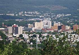
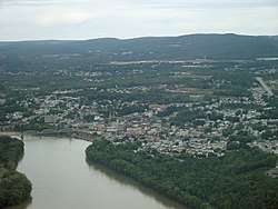
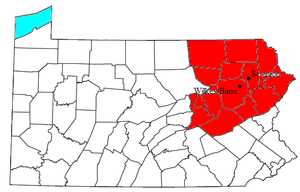
Northeastern Pennsylvania (NEPA) is a geographic region of the U.S. state of Pennsylvania that includes the Pocono Mountains, the Endless Mountains, and the industrial cities of Scranton, Wilkes-Barre, Pittston, Hazleton, Nanticoke, and Carbondale. A portion of this region constitutes a part of the New York City metropolitan area.
Northeastern Pennsylvania | |
|---|---|
  | |
 Northeastern Pennsylvania | |
| Coordinates: 41.4468°N 75.4156°W | |
| Country | United States |
| Commonwealth | Pennsylvania |
| Largest city | Scranton |
| Other cities (By population) | List
|
| Area | |
| • Total | 8,426 sq mi (21,820 km2) |
| Population (2010 Estimate) | |
| • Total | 1,349,698 |
| Time zone | UTC−5 (ET) |
| • Summer (DST) | UTC−4 (EDT) |
Unlike some other parts of the Rust Belt, some of these communities are experiencing a modest population increase. Some parts of the region, specifically Monroe and Pike counties, rank among the fastest growing areas of the state.[1]
Area
Northeastern Pennsylvania comprises Bradford County, Carbon County, Columbia County, Lackawanna County, Luzerne County, Monroe County, Montour County, Northumberland County, Pike County, Schuylkill County, Sullivan County, Susquehanna County, Wayne County and Wyoming County.
The region overlaps with the Pocono Mountains, the Endless Mountains, the Wyoming Valley, the Coal Region, Pennsylvania Dutch Country, and, by some definitions, the Lehigh Valley.
| County | 2015 Population | 2010 Population | Area |
|---|---|---|---|
| Bradford County | 61,281 | 62,622 | 1,161 sq mi (3,007 km2) |
| Carbon County | 63,960 | 65,249 | 387 sq mi (1,002 km2) |
| Columbia County | 66,672 | 67,295 | 490 sq mi (1,269 km2) |
| Lackawanna County | 211,917 | 214,437 | 465 sq mi (1,204 km2) |
| Luzerne County | 318,449 | 320,918 | 906 sq mi (2,350 km2) |
| Monroe County | 166,397 | 169,842 | 617 sq mi (1,598 km2) |
| Montour County | 18,557 | 18,267 | 132 sq mi (342 km2) |
| Northumberland County | 93,246 | 94,528 | 478 sq mi (1,238 km2) |
| Pike County | 55,949 | 57,369 | 567 sq mi (1,469 km2) |
| Schuylkill County | 144,590 | 148,289 | 783 sq mi (2,028 km2) |
| Sullivan County | 6,328 | 6,428 | 452 sq mi (1,171 km2) |
| Susquehanna County | 41,666 | 43,356 | 832 sq mi (2,155 km2) |
| Wayne County | 51,198 | 52,822 | 751 sq mi (1,945 km2) |
| Wyoming County | 27,800 | 28,276 | 405 sq mi (1,049 km2) |
| Total | 1,328,010 | 1,349,698 | 8,426 sq mi (21,823 km2) |
Green: the largest county by area; Yellow: the most populous county
Attractions and entertainment
Northeastern Pennsylvania is home to many attractions . PNC Field in Moosic hosts the Scranton/Wilkes-Barre RailRiders, the AAA affiliate to Major League Baseball's New York Yankees. Mohegan Sun Arena at Casey Plaza in Wilkes-Barre hosts the American Hockey League's Wilkes-Barre/Scranton Penguins; it previously hosted the Wilkes-Barre/Scranton Pioneers of arena football.
Pocono Raceway in Long Pond holds two NASCAR races annually.
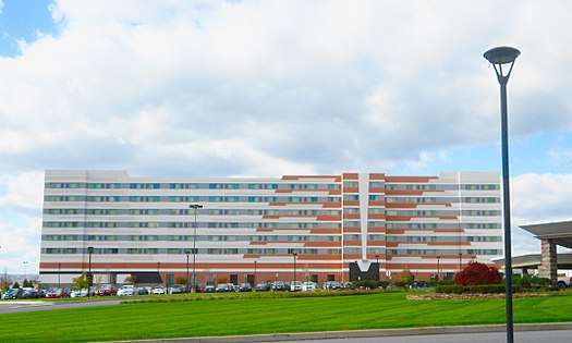
Mohegan Sun at Pocono Downs in Plains was Pennsylvania's first casino. Mount Airy Casino Resort in Mount Pocono also offers gambling.
Skiers can find several slopes in the area, including Blue Mountain Ski Resort (east of Palmerton), Montage Mountain Ski Resort in Scranton, which also operates as a water park during the summer season, Elk Mountain in Union Dale, and Camelback Ski Area in Tannersville. Like Montage, it operates as a water park in the off season.
There are several attractions that explore the region's industrial history. Eckley Miners' Village near Hazleton, and the Lackawanna Coal Mine Tour in Scranton highlight the area's coal mining history, while Steamtown National Historic Site and the Electric City Trolley Museum, both in Scranton, focus on transportation history.
The Houdini Museum in Scranton[2] follows Houdini's exploits in the area, as well as the rest of the world. The Scranton Ghost Walk attraction tells of Scranton's paranormal history.[3] 1433 N. Main Avenue, home of the longest running seance event in the United States, "Haunted! Mysteries of the Beyond", was picked by the Pennsylvania Department of tourism as one of the most haunted places in the state.[4]
NEPA is also home to the Northeastern Pennsylvania Philharmonic, the only arts and education organization in the area to successfully develop a multi-county base of support.
- An aerial view of Pocono Raceway
- Aerial View of Blue Mountain Ski Area
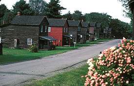 Eckley Miners' Village
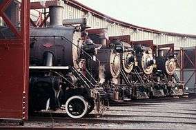 Steamtown National Historic Site
Educational institutions

Many well-known universities are located in northeastern Pennsylvania. Penn State operates campuses in the Wilkes-Barre area, near Scranton and in Hazleton. Colleges in the Scranton area include Marywood University in Dunmore, Lackawanna College in downtown Scranton, and the University of Scranton, in downtown Scranton. Geisinger Commonwealth School of Medicine is the region's only medical school and specifically recruits students from NEPA and surrounding counties.
Wilkes-Barre area colleges include Wilkes University in downtown Wilkes-Barre, King's College also in downtown Wilkes-Barre, Luzerne County Community College in Nanticoke, and Misericordia University in Dallas.
Keystone College in La Plume, St. Tikhon's Orthodox Theological Seminary in South Canaan Township, Clarks Summit University (formerly Baptist Bible College & Seminary) in Clarks Summit, Bloomsburg University in Bloomsburg, and East Stroudsburg University in East Stroudsburg are among the other colleges in the area.
Three college preparatory schools are located in northeastern Pennsylvania as well. These include the campus of Wyoming Seminary in Kingston, Scranton Preparatory School in Scranton, and MMI Preparatory School in Freeland.
Four Catholic high schools are located in northeastern Pennsylvania. They include Holy Cross High School in Dunmore, which primarily serves Lackawanna County, Luzerne County, Wayne County, Pike County, Susquehanna County, Wyoming County, and Monroe County. The second school is Holy Redeemer High School in Wilkes-Barre, which serves primarily Luzerne County and Wyoming County. The third school is Notre Dame High School, which is located in Stroudsburg. It primarily serves Monroe County. The fourth school is Our Lady of Lourdes Regional School, which is located near the city of Shamokin.
Airports
The only major airport to serve the region is the Wilkes-Barre/Scranton International Airport in Pittston Township. Several smaller airports operate in the area, including Wilkes-Barre Wyoming Valley Airport in Forty Fort, Pocono Mountains Municipal Airport in Tobyhanna, Hazleton Municipal Airport in Hazleton, Tidmore Airport in Pottsville, Stroudsburg-Pocono Airport in East Stroudsburg, Bloomsburg Municipal Airport in Bloomsburg, Cherry Ridge Airport-N30 in Honesdale, Spring Hill Airport-70N in Sterling, Mountain Bay Airpark Inc in Greentown, Flying Dollar Airport in Canadensis, Merritt Field in Muncy Valley, Boehms Field in Greeley, Beltzville Airport in Lehighton, and Skyhaven Airport in Tunkhannock.
References
- David Pierce (2010-06-25). "Population pops in Pike, Monroe counties". PoconoRecord.com. Retrieved 2014-05-20.
- JOSH MROZINSKI (Staff Writer) (2011-10-31). "Scranton's Houdini group replaces statuary bust of Harry Houdini at gravesite – News". The Times-Tribune. Retrieved 2014-05-20.
- System Administrator (2010-07-26). "Talk of the Times: Scranton Ghost Walks – Lifestyles". The Times-Tribune. Retrieved 2014-05-20.
- Christen Gruebel (2008). Pursuits Magazine, Top 10 most Haunted Places. 5. Pennsylvania Tourism Office, Commonwealth of Pennsylvania. pp. 56, 57, 58, 59, 60.

