Climate of Brazil
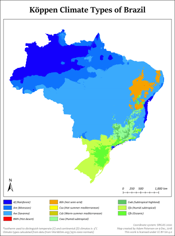
The climate in Brazil varies considerably from mostly tropical north (the equator traverses the mouth of the Amazon) to temperate zones south of the Tropic of Capricorn (23°26' S latitude).


Temperatures
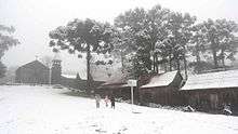
Temperatures below the equator are high, averaging above 25 °C (77 °F), but not reaching the summer extremes of up to 40 °C (104 °F) in the temperate zones. There is little seasonal variation near the equator, although at times it can get cool enough to need to wear a jacket, especially in the rain. Average temperatures below the Tropic of Capricorn are mild, ranging from 13 °C (55 °F) to 22 °C (72 °F). The highest temperature officially registered in Brazil was 44.7 °C (112.5 °F) in Bom Jesus, Piauí state on 21 November 2005.[1] The lowest temperature officially recorded in Brazil was −14 °C (7 °F) in Caçador, Santa Catarina state, on 11 June 1952.[2] However, the summit of Morro da Igreja, a mountain situated in the municipality of Urubici, also in Santa Catarina, recorded a temperature of −17.8 °C (0.0 °F) on 30 June 1996 unofficially.[3] There are frosts south of the Tropic of Capricorn during the winter (June–September).
Although most of Brazil lies in the tropics, more than 60 percent of the country's population live in areas which are cooled either by altitude, sea winds or polar fronts. While the coastal cities of Rio de Janeiro, Recife and Salvador can get extremely hot, plateau cities such as São Paulo, Brasília and Belo Horizonte have mild climates, and the southern cities of Porto Alegre and Curitiba have mild winters, but while Curitiba has a warm summer due to the average elevation of 934.6 metres (3,066 ft), Porto Alegre has a hot summer, with an average elevation of only 10 metres (33 ft).
Despite the popular image of the Amazon as a region of blistering heat, temperatures of more than 35 °C (95 °F) are unusual. The annual average temperature in the region is 22 to 26 °C (72 to 79 °F), with not much variation between the warmest and the coldest months. The hottest part of Brazil is the northeast, where temperatures of more than 38 °C (100 °F) are frequently recorded during the dry season between May and November. Along the Atlantic coast from Recife to Rio de Janeiro, average temperatures range from 23 to 27 °C (73 to 81 °F). Inland, on higher ground, temperatures are lower, ranging from 19 to 21 °C (66 to 70 °F). South of Rio the seasons are more defined and the range of temperatures significantly wider, with the annual average falling between 17 and 19 °C (63 and 66 °F). The cities of Belo Horizonte and Brasília have moderate temperatures, usually between 15 and 30 °C (59 and 86 °F), because of their elevation of approximately 1,000 metres (3,281 ft). Rio de Janeiro, Recife, and Salvador on the coast have warm climates, with average temperatures of each month ranging from 23 to 27 °C (73 to 81 °F), but enjoy constant trade winds. The cities of São Paulo, Curitiba, Florianópolis and Porto Alegre have a subtropical climate similar to that of southern United States, and temperatures can fall below freezing in winter.[4]
Precipitation
Snow falls on the high plateau and mountainous of the mountains of the states of Rio Grande do Sul, Santa Catarina, and Paraná and it is possible, but very rare, in the states of São Paulo, Rio de Janeiro, Minas Gerais, and Mato Grosso do Sul. Precipitation levels vary widely. Most of Brazil has moderate rainfall of between 1,000 and 1,500 mm (39 and 59 in) a year, with most of the rain falling in the summer (between December and April) south of the Equator. The Amazon region is notoriously humid, with rainfall generally more than 2,000 mm (79 in) per year and reaching as high as 3,000 mm (118 in) in parts of the western Amazon and near Belém. It is less widely known that, despite high annual precipitation, the Amazon forest has a three- to five-month dry season, the timing of which varies according to location north or south of the equator.
High and relatively regular levels of precipitation in the Amazon contrast sharply with the dryness of the semiarid Northeast, where rainfall is highly erratic and there are severe droughts in cycles averaging seven years. The Northeast is the driest part of the country. The region also constitutes the hottest part of Brazil, where during the dry season between May and November, temperatures of more than 40 °C (104 °F) are common. However, the sertão, a region of semidesert vegetation used primarily for low-density ranching, turns green when there is rain. Most of the Center-West has 1,500 to 2,000 mm (59 to 79 in) of rain per year, with a pronounced dry season in the middle of the year, while the South and most of the East is without a distinct dry season.
Brazil's most intense rain falls around the mouth of the Amazon near the city of Belém, and also in the upper regions of Amazonia where more than 2,000 millimetres (79 in) of rain fall every year. The warm weather lets many plant grow here. Most of Brazil has moderate rainfall of between 1,000 and 1,500 millimetres (39 and 59 in) a year, most of it coming between December and April. The driest part of the country is the northeast, where rainfall is erratic and the evaporation rate very high, making it difficult to grow crops.
Extreme weather
Because the South Atlantic basin is generally not a favorable environment for their development, Brazil has only rarely experienced tropical cyclones. The country's coastal population centers are considered less burdened with the need to prepare for cyclones, as are cities at similar latitudes in the United States and Asia.
See also
- Effects of global warming
- Effects of global warming on Brazil
- Geography of Brazil
- Regional effects of global warming
References
- (in Portuguese) Piauí tem a temperatura mais alta em 96 anos, Terra, November 26, 2005.
- (in Portuguese) Recordes de frio em SC Archived 2012-09-13 at the Wayback Machine, EPAGRI/CIRAM, retrieved May 15, 2013.
- (in Portuguese) Sibéria brasileira no sul do Brasil ("Brazilian Siberia in the South of Brazil"), Fantástico, July 18, 2006.
- Brasil - HotelStore.net - Hotel Reservations / Reservas de Hotel, archived from the original on 2013-06-07, retrieved 2018-03-31