Bethune, Saskatchewan
Bethune /ˈbɛθ.juːn/[5] (2016 population: 399) is a village in the Canadian province of Saskatchewan within the Rural Municipality of Dufferin No. 190 and Census Division No. 6. The village is 56 km northwest of Regina on Highway 11 (Louis Riel Trail).[6] Arm River flows along a river valley north of Bethune, which features camping sites, and the Qu'Appelle River is a short way south. Last Mountain Lake or Long Lake is northeast of Bethune whereas Buffalo Pound Lake is just southwest.
Bethune | |
|---|---|
| Village of Bethune | |
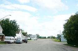
 Main Street Bethune | |
 Bethune Location of Bethune in Saskatchewan | |
| Coordinates: 50°43′N 105°13′W | |
| Country | Canada |
| Province | Saskatchewan |
| Region | Southwest |
| Census division | 6 |
| Rural Municipality | Dufferin No. 190 |
| Post office Founded | 1905-06-05 |
| Incorporated (Village) | 1912 |
| Government | |
| • Type | Municipal |
| • Governing body | Bethune Village Council |
| • Mayor | Derek Shaw[1] |
| • Administrator | Rodney Audette |
| Area | |
| • Total | 1.04 km2 (0.40 sq mi) |
| Population (2016)[2] | |
| • Total | 399 |
| • Density | 383.1/km2 (992/sq mi) |
| Time zone | UTC-6 (Central) |
| Postal code | S0G 0H0 |
| Area code(s) | 306 |
| Highways | Hwy 642 |
| Website | www |
| [3][4] | |
The post office of Bethune, Assiniboia, NWT was established 5 June 1905, three months before Saskatchewan became a province. The village takes its name from C.B. Bethune, the engineer on the first train to travel the railway in 1887.[7]
History
Bethune incorporated as a village on August 2, 1912.[8]
Demographics
In the 2016 Census of Population conducted by Statistics Canada, the Village of Bethune recorded a population of 399 living in 158 of its 181 total private dwellings, a -1.5% change from its 2011 population of 405. With a land area of 2.38 km2 (0.92 sq mi), it had a population density of 167.6/km2 (434.2/sq mi) in 2016.[11]
In the 2011 Census of Population, the Village of Bethune recorded a population of 400, a 8.4% change from its 2006 population of 369. With a land area of 1.04 km2 (0.40 sq mi), it had a population density of 384.6/km2 (996.1/sq mi) in 2011.[12]
Attractions
Buffalo Pound Provincial Park is located within 19 km or 12 mi. Grandview Beach is also located 19 km or 12 mi from Bethune. Kedleston Beach is closer: 15 km or 9 mi from Bethune. Another conservation area named Regina Beach Recreation Site is located 19 km or 12 mi from Bethune.
The Gillis Blakley Bethune and District Heritage Museum is a Municipal Heritage Property on the Canadian Register of Historic Places.[13]
See also

References
- Administration & Governance
- "2011 Community Profiles". Statistics Canada. Government of Canada. Retrieved 2014-08-21.
- National Archives, Archivia Net. "Post Offices and Postmasters". Archived from the original on 2006-10-06. Retrieved 2014-08-21.
- Government of Saskatchewan, MRD Home. "Municipal Directory System". Archived from the original on 2016-01-15. Retrieved 2014-08-21.
- The Canadian Press (2017), The Canadian Press Stylebook (18th ed.), Toronto: The Canadian Press
- http://www.villageofbethune.com/
- Village of Bethune
- "Urban Municipality Incorporations". Saskatchewan Ministry of Government Relations. Archived from the original on October 15, 2014. Retrieved June 1, 2020.
- "Saskatchewan Census Population" (PDF). Saskatchewan Bureau of Statistics. Archived from the original (PDF) on September 24, 2015. Retrieved May 31, 2020.
- "Saskatchewan Census Population". Saskatchewan Bureau of Statistics. Retrieved May 31, 2020.
- "Population and dwelling counts, for Canada, provinces and territories, and census subdivisions (municipalities), 2016 and 2011 censuses – 100% data (Saskatchewan)". Statistics Canada. February 8, 2017. Retrieved May 30, 2020.
- "Population and dwelling counts, for Canada, provinces and territories, and census subdivisions (municipalities), 2011 and 2006 censuses (Saskatchewan)". Statistics Canada. June 3, 2019. Retrieved May 30, 2020.
- "Archived copy". Archived from the original on 2012-02-24. Retrieved 2009-01-06.CS1 maint: archived copy as title (link) Canadian Register of Historic Places.
Further reading
- Wagon trails to blacktop: A history of Bethune. Published: Bethune, Sask. Bethune & District Historical Society. 1983. ISBN 0-919845-12-6.[1]
External links
- WebPAC PRO © Innovative Interfaces, Inc., University of Saskatchewan Online Library Database, retrieved August 6, 2007
