Brookfield, Wisconsin
Brookfield is a city located in Waukesha County, Wisconsin, United States in the Milwaukee metropolitan area. It had a population of 37,920 in the 2010 census.[6] Brookfield is the third largest city in Waukesha County. The city is adjacent to the Town of Brookfield.
Brookfield, Wisconsin | |
|---|---|
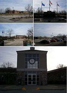 From top left clockwise: Brookfield Central High School, Veterans Memorial Fountain, Brookfield Square Mall, Brookfield City Hall, and the Brookfield Safety Building | |
 Flag  Seal | |
| Motto(s): Minutes from Milwaukee, Miles from Expected | |
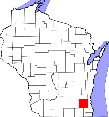
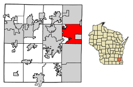 Location of Brookfield in Waukesha County, Wisconsin | |
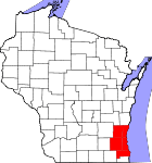
 Brookfield Location in Wisconsin  Brookfield Brookfield (the United States) | |
| Coordinates: 43°3′29″N 88°6′53″W | |
| County | Waukesha |
| Incorporated | August 14, 1954 |
| Government | |
| • Type | Mayor–council[1] |
| • Mayor | Steven V. Ponto[2] |
| Area | |
| • City | 27.66 sq mi (71.63 km2) |
| • Land | 27.29 sq mi (70.68 km2) |
| • Water | 0.37 sq mi (0.95 km2) 1.327% |
| Elevation | 830 ft (253 m) |
| Population | |
| • City | 37,920 |
| • Estimate (2019)[5] | 39,115 |
| • Density | 1,433.31/sq mi (553.41/km2) |
| • Metro | 1,760,268 |
| The population figure given for the metropolitan area is for the Milwaukee metropolitan area, which includes Brookfield | |
| Time zone | UTC−6 (Central) |
| • Summer (DST) | UTC−5 (Central) |
| Postal Code(s) | 53045, 53005, 53072 |
| Area code(s) | 262 |
| FIPS code | 55-10025 |
| Website | www |
History
Brookfield is west of Milwaukee in Waukesha County in an area originally inhabited by Potawatomi Indians.[7] The first white settler, William Howe, arrived in 1820 with a Presidential Land Grant giving him title to the area. Soon after, Robert Curren bought a claim in 1836, and established a tavern and inn.[8]
In May 1838, Jacques View Jr., with a large party of white settlers, lead the local Potawatomi west. By 1839, the population needed a school house, as the 1840 census showed a population of 148. In these 1840s, George Gebhardt started trading with the surrounding Potawatomi and Menominee neighbors. 1843 is when the first church was built, by the Irish Catholic congregation, named St. Dominic. 1848 was when telegraph lines were laid through Brookfield, towards Waukesha. Communication was made easier due to this. In 1849, cholera reached Brookfield, and one Laura Grover recalls, "The death-like stillness was appalling; nothing was seen but the death carts rolling round the streets gathering the recent dead... I believe there were fifty deaths from cholera that day." The same year, 64 Brookfield residents voted in favor of giving suffrage to black residents, and 0 the other way. In 1850, cholera again went through Brookfield, and according to one Earl Thayer, "The cholera returned... more terrible than the year before. People literally died walking along the streets. Official reports put the toll at over 300."[9]
In 1850, the Milwaukee and Mississippi Railroad (now the Canadian Pacific Rail) built a railroad through the town, which in 1853 erected a depot, forming the Brookfield Junction. In the year 1850, the Town of Brookfield had 1,944 inhabitants and in land area covered 36 square miles. The town slowly grew over following years, with the economy being mostly agricultural, with Brookfield Junction serving as a commercial center for the surrounding farms.[8] The Civil War, an important part of American history, had little affect to this town.[9] In 1867, a second rail depot was constructed, which still stands.[8]
In the 1900s, Brookfield gained a new reputation. Waukesha County was called Cow County, U.S.A., as according to advertisers, they claimed that in the county there were more cows than people. This was, of course, fantastical, although there were cows. This did help cement Wisconsin's dairy reputation. WWI, one of the biggest wars in history, also didn't have too much of an effect on Brookfield and how we know it today. The Spanish flu, however, did kill many people, but not as many as cholera had in the past.[9] On May 31, 1914, a tornado hit, devastating the farmers and the rural area.[10]
This quiet, rural atmosphere attracted one notorious resident, Al Capone, as he established an area to live and a distillery on Brookfield Road.[11] In 1928, the first suburban development, Kinsey's Garvendale, a residential subdivision, was created. Early subdivisions grew slowly due to the Great Depression hitting a year later, affecting its growth and killing demand.
Development in Brookfield began to increase after the Second World War. Suburban development was encouraged by a lack of housing, the baby boom, and government sponsored building programs, which further grew the town, and after several annexations of neighboring communities, an incorporation drive started. The City of Brookfield was incorporated from the town of Brookfield, a portion of which still survives along the city's western edge, on August 14, 1954. The first mayor was Franklin Wirth, and he oversaw the new city, which at the time had a population of 7,900 and covered an area of 17.5 square miles. Much of the land was still in agricultural use, so the city's founders encouraged orderly development of office and industrial areas to cause the community to function with strong industrial and commercial base.
Today, Brookfield covers 27.66 square miles, and numbers 37,920 residents.[8]
Geography and climate
According to the United States Census Bureau, the city has a total area of 27.59 square miles (71.46 km2), of which 27.29 square miles (70.68 km2) is land and 0.367 square miles (0.95 km2) is water.[12] The sub-continental divide passes through Brookfield; on the eastern side of this divide, easily marked by the crest at Calhoun Road and Capitol Drive, water flows to Lake Michigan on its way to the Gulf of Saint Lawrence; on the western side of this divide, water flows to the Fox River of Illinois and Wisconsin on its way to the Mississippi River and the Gulf of Mexico.
There is a heron rookery on a site northwest of Capitol Drive and Brookfield Road.[13]
The Köppen-Geiger climate classification system classifies its climate as humid continental (Dfa).
| Climate data for Brookfield, Wisconsin (1981–2010 normals) | |||||||||||||
|---|---|---|---|---|---|---|---|---|---|---|---|---|---|
| Month | Jan | Feb | Mar | Apr | May | Jun | Jul | Aug | Sep | Oct | Nov | Dec | Year |
| Record high °F (°C) | 62 (17) |
66 (19) |
82 (28) |
91 (33) |
101 (38) |
101 (38) |
109 (43) |
102 (39) |
101 (38) |
88 (31) |
78 (26) |
68 (20) |
109 (43) |
| Average high °F (°C) | 27.8 (−2.3) |
31.9 (−0.1) |
43.1 (6.2) |
56.4 (13.6) |
67.8 (19.9) |
78.0 (25.6) |
81.9 (27.7) |
79.9 (26.6) |
72.7 (22.6) |
59.8 (15.4) |
45.4 (7.4) |
31.5 (−0.3) |
56.4 (13.6) |
| Average low °F (°C) | 10.7 (−11.8) |
14.4 (−9.8) |
23.5 (−4.7) |
35.0 (1.7) |
45.0 (7.2) |
54.8 (12.7) |
59.8 (15.4) |
58.6 (14.8) |
49.8 (9.9) |
38.3 (3.5) |
27.7 (−2.4) |
15.4 (−9.2) |
36.1 (2.3) |
| Record low °F (°C) | −29 (−34) |
−28 (−33) |
−14 (−26) |
7 (−14) |
25 (−4) |
29 (−2) |
41 (5) |
35 (2) |
25 (−4) |
7 (−14) |
−9 (−23) |
−28 (−33) |
−29 (−34) |
| Average precipitation inches (mm) | 1.45 (37) |
1.42 (36) |
1.78 (45) |
3.39 (86) |
3.49 (89) |
4.36 (111) |
3.85 (98) |
4.58 (116) |
3.39 (86) |
2.61 (66) |
2.48 (63) |
1.81 (46) |
34.61 (879) |
| Average snowfall inches (cm) | 12.3 (31) |
8.6 (22) |
5.6 (14) |
1.8 (4.6) |
0 (0) |
0 (0) |
0 (0) |
0 (0) |
0 (0) |
0.1 (0.25) |
1.6 (4.1) |
10.1 (26) |
40.0 (102) |
| Average precipitation days (≥ 0.01 in) | 9.2 | 7.5 | 7.9 | 10.7 | 11.8 | 10.7 | 9.4 | 9.1 | 8.8 | 9.4 | 8.8 | 9.5 | 112.8 |
| Average snowy days (≥ 0.1 in) | 6.8 | 5.1 | 3.5 | 1.0 | 0 | 0 | 0 | 0 | 0 | 0.1 | 1.1 | 6.2 | 23.8 |
| Source: NOAA[14] | |||||||||||||
Demographics
| Historical population | |||
|---|---|---|---|
| Census | Pop. | %± | |
| 1960 | 19,812 | — | |
| 1970 | 31,761 | 60.3% | |
| 1980 | 34,035 | 7.2% | |
| 1990 | 35,184 | 3.4% | |
| 2000 | 38,649 | 9.8% | |
| 2010 | 37,920 | −1.9% | |
| Est. 2019 | 39,115 | [5] | 3.2% |
| U.S. Decennial Census[15] | |||
2010 census
As of the census[4] of 2010, there were 37,920 people, 14,576 households, and 10,999 families residing in the city. The population density was 1,399.8 inhabitants per square mile (540.5/km2). There were 15,317 housing units at an average density of 565.4 per square mile (218.3/km2). The racial makeup of the city was 90.0% White, 1.2% African American, 0.2% Native American, 6.7% Asian, 0.5% from other races, and 1.4% from two or more races. Hispanic or Latino of any race were 2.2% of the population.
There were 14,576 households, of which 31.5% had children under the age of 18 living with them, 67.4% were married couples living together, 5.4% had a female householder with no husband present, 2.6% had a male householder with no wife present, and 24.5% were non-families. 21.4% of all households were made up of individuals, and 11.9% had someone living alone who was 65 years of age or older. The average household size was 2.57 and the average family size was 3.01.
The median age in the city was 46.7 years. 23.5% of residents were under the age of 18; 5.2% were between the ages of 18 and 24; 18.5% were from 25 to 44; 33% were from 45 to 64; and 19.9% were 65 years of age or older. The gender makeup of the city was 48.5% male and 51.5% female.
2000 census
As of the census[6] of 2000, there were 38,649 people, 13,891 households, and 11,223 families residing in the city. The population density was 1,421.1 people per square mile (548.6/km2). There were 14,208 housing units at an average density of 522.4 per square mile (201.7/km2). The racial makeup of the city was 94.20 percent White, 3.83 percent Asian, 0.83 percent Black or African American, 0.09 percent Native American, 0.02 percent Pacific Islander, 0.23 percent from other races, and 0.81 percent from two or more races. 1.17 percent of the population were Hispanic or Latino of any race.
There were 13,891 households, out of which 36.1 percent had children under age 18 living with them, 73.1 percent were married couples living together, 5.5 percent had a female householder with no husband present, and 19.2 percent were non-families. 16.7 percent of all households were made up of individuals, and 9.0 percent had someone living alone who was 65 years old or older. The average household size was 2.74 people and the average family size was 3.09 people.
In the city, the population was spread out, with 26.8 percent under age 18, 4.6 percent from 18 years old to 24 years old, 23.2 percent from 25 years old to 44 years old, 27.8 percent from 45 years old to 64 years old, and 17.6 percent who were 65 years old or older. The median age was 42 years. For every 100 females, there were 93.7 males. For every 100 females age 18 and over, there were 90.8 males.
The median income for a household in the city was $76,225, and the median income for a family was $83,691. Males had a median income of $62,351 versus $37,589 for females. The per capita income for the city was $37,292. 2.2 percent of the population and 1.4 percent of families were below the poverty line. Out of the total population, 2.4 percent of those under age 18 and 3.4 percent of those 65 years old and older were living below the poverty line.
Economy
Fiserv is headquartered in Brookfield.[16] The firm provides financial services technology (software, for the most part) for banks, thrifts, credit unions, securities broker dealers, leasing and finance companies, and retailers, among others. Its 2016 revenue was approximately $5.5 billion.[17]
Fedex's SmartPost business unit is also headquartered in Brookfield.[18][19]
Transportation
Capitol Airport (02C) serves the city and surrounding communities.
Government
Brookfield has a mayor–council government. The mayor is elected to a four-year term. On April 1, 2014, incumbent mayor Steve Ponto again defeated former two-term Mayor Jeff Speaker by a vote of 4,512 to 2,539.[20] On April 3, 2018, incumbent mayor Steve Ponto ran unopposed for mayor.[21]
Brookfield is represented by Jim Sensenbrenner (R) in the United States House of Representatives, and by Ron Johnson (R) and Tammy Baldwin (D) in the United States Senate. Brookfield is represented by Dale Kooyenga (R) in the Wisconsin State Senate and Rob Hutton (R) and Robyn Beckley Vining (D) in the Wisconsin State Assembly.
Common Council
The Common Council is composed of 14 aldermen, with two representing each of seven districts. They serve four-year terms, with one member from each district up for election every other year. The aldermen set policy and have extensive financial control, but are not engaged in daily operational management.
| District | Aldermen (2018–2022)[22] | Aldermen (2016–2020) |
|---|---|---|
| 1 | Bill Carnell | Daniel Sutton |
| 2 | Bob Reddin | Rick Owen |
| 3 | Jeff McCarthy | Ron Balzer |
| 4 | Mark Nelson | Edward "Buck" Jurken |
| 5 | Gary Mahkorn | Scott Berg |
| 6 | Gerald Mellone | Christopher Blackburn |
| 7 | Brad Blumer | Renee Lowerr |
Education
The Elmbrook School District serves residents of Brookfield excluding a small section of southwest Brookfield, which is in the Waukesha School District. Private schools include St. Dominic Catholic School, St. John Vianney Catholic Church, St. Luke Catholic School, St. Joseph's Catholic School, Elm Grove Lutheran School, Brookfield Christian School, and Brookfield Academy. Private high schools located within the Brookfield city limits include Brookfield Academy and Heritage Christian School, West Suburban Christian Academy.[23]
Tourism
Brookfield offers shopping, fine dining, outdoor golf and parks. Brookfield's concert hall is the Sharon Lynne Wilson Center for the Arts located in Mitchell Park. Brookfield's main beach is located at Fox Brook Park where hiking in natural preserves, sailing, biking and golfing are also available.
Brookfield Square is the main shopping mall for the city and also serves as a commercial anchor to the Bluemound Road shopping district serving the western suburbs of Milwaukee and Waukesha County. Brookfield has off-road bike paths throughout the city.
Brookfield Days is held annually in June, at Wirth Park supported by the local community. A farmer's market runs on weekends in summer months at the Brookfield City Hall.
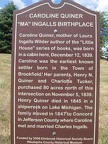
The Elmbrook Historical Society hosts several events annually celebrating the lives of early Brookfield settlers, including Caroline Ingalls, who was born in the Brookfield area. The city is often visited by fans of her daughter, Laura, author of the Little House on the Prairie book series.
Notable people
- John Anderson, NFL player
- Ken Anderson, pro wrestler known as Mr. Kennedy
- Al Capone, noted Chicago mobster, owned a Brookfield home where moonshine was made[7][24]
- Bill Carollo, NFL official
- Kip Carpenter, 2002, 2006 Olympian, bronze medalist in speedskating
- Henry J. Clasen, Wisconsin State Representative and businessman[25]
- Tom Dougherty, MLB player
- Arpad Elo, inventor of Elo rating system for chess, professor at Marquette
- Susan Engeleiter, former administrator of the Small Business Administration
- Herman Finger, entrepreneurial lumberman
- Aubrey Foard, Charlotte Symphony Orchestra principal tuba.[26][27]
- Troy Grosenick, professional ice hockey goaltender for the Nashville Predators
- Doc Hamann, MLB player
- Merle Harmon, Hall of Fame broadcaster and entrepreneur
- Kenny Harrison, world champion track and field athlete, Olympic gold medalist
- Nathan Hatch (1757-1847), soldier in American Revolutionary War and War of 1812; farmed in Brookfield from 1842-1847 and interred in Brookfield's Oak Hill Cemetery[28][29][30][31]
- Caroline Ingalls (1839–1924), born in what is today the city of Brookfield (then Town of Brookfield), mother of Laura Ingalls Wilder
- Ken Jungels, MLB player
- Ted Kanavas (1961-2017), Wisconsin State Senate[32]
- Matt Katula, NFL player
- Joe Kuether, professional poker player
- Robert Andrew "Bob" Long, wide receiver for Green Bay Packers during Vince Lombardi era
- Arie Luyendyk, two-time Indianapolis 500 winner
- Eddie Mathews, baseball player (lived in Brookfield during career)
- Al McGuire, former NCAA basketball coach and commentator (lived in Brookfield toward the end of his life)
- Fritz Mollwitz, MLB player
- Brad Nortman, NFL punter
- Leslie Osborne, member of Women's Professional Soccer team Boston Breakers and the U.S. national team
- Joe Panos, football player for Philadelphia Eagles, Buffalo Bills
- James Kerr Proudfit, U.S. Army general
- Martin P. Robinson, puppeteer for Telly Monster, Mr. Snuffleupagus and Slimey on Sesame Street since 1980; graduate of Brookfield East High School
- Herman Schatz, Wisconsin State Representative and blacksmith
- Richie Sexson, retired MLB player (lived here when he played for Milwaukee Brewers)
- Paul Spaeth, noted composer and musician
- Adam Stockhausen, Oscar-winning production designer
- John Patten Story, U.S. Army major general[33][34]
- Joe Thomas, football player for Cleveland Browns
- Frank Urban, Wisconsin State Assembly
- John M. Young, Wisconsin State Assembly
Sister cities
Brookfield has one sister city:

See also
- 2012 Azana Spa shootings
- 2005 Living Church of God shooting
- Milwaukee Electric Tool Corporation
References
- "Elected Officials - Brookfield, WI". Retrieved 2019-12-18.
- "City of Brookfield Official Web Site". Retrieved 2010-04-28.
- "2019 U.S. Gazetteer Files". United States Census Bureau. Retrieved August 7, 2020.
- "U.S. Census website". United States Census Bureau. Retrieved 2012-11-18.
- "Population and Housing Unit Estimates". United States Census Bureau. May 24, 2020. Retrieved May 27, 2020.
- "U.S. Census website". United States Census Bureau. Retrieved 2008-01-31.
- Brookfield (brief history) Wisconsin State Historical Society
- About Brookfield-History
- Ramstack, Thomas. (2007). Brookfield : a fine and fertile land : an early history of the town of Brookfield, Waukesha County, Wisconsin (2nd ed., reviewed & revised ed.). [Milwaukee, WI?]: T. Ramstack. ISBN 9781598729986. OCLC 226304651.
- Ramstack, Thomas. (2009). Brookfield and Elm Grove. Charleston, SC: Arcadia Pub. ISBN 9780738560700. OCLC 311792802.
- "Gangster's paradise". www.gmtoday.com. Retrieved 2019-07-01.
- "US Gazetteer files 2018". United States Census Bureau. Retrieved 2019-05-26.
- Sink, Lisa (July 12, 2008). "Brookfield heron rookery in danger of disappearing". Milwaukee Journal Sentinel. Retrieved 2009-04-30.
- "NowData – NOAA Online Weather Data". National Oceanic and Atmospheric Administration. Retrieved 2013-07-12.
- "Census of Population and Housing". Census.gov. Retrieved June 4, 2015.
- "About Us, Fiserv Innovation and Technology | Fiserv". www.fiserv.com. Retrieved 2019-01-15.
- "EDGAR Filing Documents for 0000798354-17-000006". www.sec.gov. Retrieved 2019-01-15.
- "FedEx SmartPost Hub Network". FedEx SmartPost Network. FedEx Corporation. 2018. Retrieved 2018-03-01.
- "SurePost Product Information Page | UPS". UPS Home. United Parcel Service (UPS). Retrieved 2018-03-01.
- Linnane, Rory (April 1, 2014). "Ponto takes wide lead in mayoral election, defeating Speaker". BrookfieldNow. Retrieved 2014-05-05.
- "No race for mayor in Brookfield, but April 3 ballot in rest of West area taking shape".
- "Election results: Wisconsin and Milwaukee-area spring general election". Milwaukee Journal Sentinel. April 3, 2018. Retrieved 2018-05-14.
- "Elmbook Schools and the 220 Program". Archived from the original on 2012-07-17. Retrieved 2012-01-07.
- City of Brookfield official web site
- 'Wisconsin Blue Book 1874,' Biographical Sketch of Henry J. Clasen, pg. 470
- Charlotte Symphony - Aubrey Foard
- Aubrey Foard - Professional Tubist and Brass Teacher
- "Unveil Marker Soldier 1776". Waukesha Freeman. June 18, 1918. Retrieved 2012-05-27.
- "Wisconsin Society Sons of the American Revolution". Archived from the original on 2010-05-12. Retrieved 2009-11-17.
- Nathan Hatch Waymark
- Sink, Lisa (May 26, 2012). "Descendants, City Honor Revolutionary War Veteran Buried in Brookfield". Brookfield Patch. Archived from the original on July 8, 2012. Retrieved 2012-05-27.
- 'Wisconsin Blue Book 2007-2008,' Biographical Sketch of Theodore Kanavas, pg. 84
- The History of Waukesha County, Wisconsin. Chicago, IL: Western Historical Company. 1880 – via Internet Archive.
- Cullum, George W.; Robinson, Wirt (1920). Biographical Register of the Officers and Graduates of the United States Military Academy. Supplement, Volume VI-A. Saginaw, MI: Seemann & Peters. p. 111 – via Google Books.
