Fox Point, Wisconsin
Fox Point is a village in Milwaukee County, Wisconsin, United States. The population was 6,701 at the 2010 census.
Fox Point, Wisconsin | |
|---|---|
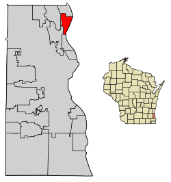
 Location of Fox Point in Milwaukee County, Wisconsin. | |
| Coordinates: 43°9′37″N 87°54′14″W | |
| Country | |
| State | |
| County | Milwaukee |
| Incorporated | 1926 |
| Area | |
| • Total | 2.86 sq mi (7.41 km2) |
| • Land | 2.86 sq mi (7.41 km2) |
| • Water | 0.00 sq mi (0.00 km2) |
| Elevation | 686 ft (209 m) |
| Population | |
| • Total | 6,701 |
| • Estimate (2019)[4] | 6,543 |
| • Density | 2,287.76/sq mi (883.32/km2) |
| Time zone | UTC-6 (Central (CST)) |
| • Summer (DST) | UTC-5 (CDT) |
| Area code(s) | 414 |
| FIPS code | 55-27075[5] |
| GNIS feature ID | 1565227[2] |
| Website | vil |
Fox Point is located along the North Shore area of the Milwaukee metropolitan area. It is named after a small point extending into Lake Michigan.[6] In addition to Lake Michigan, it adjoins the surrounding communities of Bayside, River Hills, Glendale, and Whitefish Bay. Mainly residential, Fox Point is also home to the RiverPoint Village shopping center at the far northwest end of the village.
History
Dutch settlers arrived in what is now Fox Point (then part of Milwaukee) as early as the 1840s, building a schoolhouse, a Dutch Reformed congregation, and a cemetery that has markers dating to 1854.[7][8] Today the Dutch Pioneer Cemetery is a Wisconsin registered landmark. As the 1800s progressed, other immigrant groups, primarily Germans, settled in the area.[7]
By the 1920s, affluent merchants and business owners moved with their families into the area and Fox Point was incorporated as a village in 1926, although the population remained in the hundreds through World War II.[7][9] After his death in 1928, physician Joseph Schneider left his land to Milwaukee County for the establishment of a park and beachfront reserve now known as "Doctors Park", which was dedicated in 1936.[7] In the post-war boom, Fox Point grew, with its population peaking in the 1970s at nearly 8,000. The village's population has remained steady – near 7,000 people – in the decades since.[10]
Geography
Fox Point is located at 43°9′37″N 87°54′14″W (43.160409, -87.903994).[11]
According to the United States Census Bureau, the village has a total area of 2.90 square miles (7.51 km2), all of it land.[12]
Climate
Fox Point, situated within the humid continental climate zone (Köppen prefix D), experiences distinct seasonal variation, with wide swings in temperature and precipitation.[13] The village's immediate proximity to Lake Michigan makes it susceptible to lake-effect snow in the winter months.
The warmest month of the year in Fox Point is July, with a high temperature average of 84 °F (28.9 °C) and low temperatures of 64 °F (17.8 °C). The summer months are the wettest months of the year, with frequent thunderstorms in the region. January is the coldest month, with average high temperatures averaging only 30 °F (-1.1 °C), and lows averaging 14 °F (-10 °C).[14] February is the driest month.
| Climate data for Mequon, Wisconsin | |||||||||||||
|---|---|---|---|---|---|---|---|---|---|---|---|---|---|
| Month | Jan | Feb | Mar | Apr | May | Jun | Jul | Aug | Sep | Oct | Nov | Dec | Year |
| Average high °F (°C) | 30 (−1) |
34 (1) |
45 (7) |
58 (14) |
69 (21) |
79 (26) |
84 (29) |
81 (27) |
74 (23) |
61 (16) |
47 (8) |
34 (1) |
58 (14) |
| Average low °F (°C) | 14 (−10) |
17 (−8) |
26 (−3) |
37 (3) |
48 (9) |
58 (14) |
64 (18) |
62 (17) |
53 (12) |
41 (5) |
30 (−1) |
19 (−7) |
39 (4) |
| Average precipitation inches (mm) | 1.38 (35) |
1.35 (34) |
1.62 (41) |
3.36 (85) |
3.29 (84) |
4.04 (103) |
3.70 (94) |
3.74 (95) |
3.20 (81) |
2.31 (59) |
2.35 (60) |
1.55 (39) |
31.89 (810) |
| Source: The Weather Channel[14] | |||||||||||||
Demographics
| Historical population | |||
|---|---|---|---|
| Census | Pop. | %± | |
| 1930 | 474 | — | |
| 1940 | 1,180 | 148.9% | |
| 1950 | 2,585 | 119.1% | |
| 1960 | 7,315 | 183.0% | |
| 1970 | 7,939 | 8.5% | |
| 1980 | 7,649 | −3.7% | |
| 1990 | 7,238 | −5.4% | |
| 2000 | 7,012 | −3.1% | |
| 2010 | 6,701 | −4.4% | |
| Est. 2019 | 6,543 | [4] | −2.4% |
| U.S. Decennial Census[15] | |||
2010 census
As of the census[3] of 2010, there were 6,701 people, 2,747 households, and 1,859 families residing in the village. The population density was 2,310.7 inhabitants per square mile (892.2/km2). There were 2,928 housing units at an average density of 1,009.7 per square mile (389.8/km2). The racial makeup of the village was 91.5% White, 2.8% African American, 0.1% Native American, 3.7% Asian, 0.4% from other races, and 1.4% from two or more races. Hispanic or Latino of any race were 2.4% of the population.
There were 2,747 households, of which 29.7% had children under the age of 18 living with them, 60.5% were married couples living together, 5.1% had a female householder with no husband present, 2.0% had a male householder with no wife present, and 32.3% were non-families. 28.4% of all households were made up of individuals, and 14% had someone living alone who was 65 years of age or older. The average household size was 2.36 and the average family size was 2.92.
The median age in the village was 45.6 years. 22.8% of residents were under the age of 18; 7% were between the ages of 18 and 24; 19.4% were from 25 to 44; 32.4% were from 45 to 64; and 18.4% were 65 years of age or older. The gender makeup of the village was 49.0% male and 51.0% female.
2000 census
As of the census[5] of 2000, there were 7,012 people, 2,825 households, and 1,988 families residing in the village. The population density was 2,399 people per square mile (927.2/km2). There were 2,910 housing units at an average density of 995.7 per square mile (384.8/km2). The racial makeup of the village was 95.55% White, 1.21% African American, 0.11% Native American, 2.14% Asian, 0.01% Pacific Islander, 0.19% from other races, and 0.78% from two or more races. Hispanic or Latino of any race were 1.06% of the population.
There were 2,825 households, out of which 30.6% had children under the age of 18 living with them, 62.4% were married couples living together, 6.1% had a female householder with no husband present, and 29.6% were non-families. 27.3% of all households were made up of individuals, and 13.8% had someone living alone who was 65 years of age or older. The average household size was 2.39 and the average family size was 2.93.
In the village, the population was spread out, with 23.9% under the age of 18, 6.1% from 18 to 24, 22.9% from 25 to 44, 27.0% from 45 to 64, and 20.0% who were 65 years of age or older. The median age was 44 years. For every 100 females, there were 89.9 males. For every 100 females age 18 and over, there were 84.9 males.
The median income for a household in the village was $80,572, and the median income for a family was $94,348. Males had a median income of $77,850 versus $38,500 for females. The per capita income for the village was $48,469. About 1.8% of families and 2.8% of the population were below the poverty line, including 4.1% of those under age 18 and 3.8% of those age 65 or over.
Government and politics

The government of the Village of Fox Point consists of a village board, and its committees, which monitor aspects of village government performance. The board consists of six trustees and a president, who are elected to serve three-year terms. The current president is Douglas Frazer, whose term will expire in 2020.[9] The board has three committees: a finance committee of three members, which oversees economic matters; an audit committee with three trustees and two residents who assist the finance committee; and a three-member administration committee, which oversees new village laws. Other committees, boards, and commissions include the board of appeals, board of police commissioners, board of reviews, building board, board of ethics, the fair housing commission, and the historic preservation committee. In Fox Point the president also appoints a trustee and a resident to serve on the board of the North Shore Public Library.
In the Wisconsin State Senate, Fox Point is part of the 8th Senate District, held by Republican Alberta Darling, while Republican Jim Ott represents the village in the Wisconsin Assembly.[16][17] At the federal level, Fox Point is represented in Congress by Rep. Gwen Moore, a Democrat.[18]
Education
For students in kindergarten through 8th grade, Fox Point is part of two public school districts: the Fox Point-Bayside School District and the Maple Dale-Indian Hill School District. Both school districts are feeders for Nicolet High School. St. Eugene Catholic Grade School, a private Catholic school serving students from preschool through 8th grade, is also located in the village, as is Fox Point Preschool, part of Fox Point Lutheran Church.[19][20] Portions of Cardinal Stritch University's campus are located within village boundaries, though the university's official mailing address is in Glendale.
The North Shore Public Library, located in neighboring Glendale, serves the community. Its board is a multi-municipal body with representatives from Fox Point, Bayside, Glendale, and Brown Deer. The library is a member of the Milwaukee County Federated Library System, and it therefore serves residents from across Milwaukee County.[21]
Economy
The Chipstone Foundation has its headquarters in Fox Point. There are also many stores, mainly located in the River Point Shopping Mall, Fox Point Stores Mall, and the Audubon Center.
Historic places
- The Albert and Edith Adelman House, designed by Frank Lloyd Wright and listed on the National Register of Historic Places, is located in Fox Point.
- Mary Nohl Art Environment, containing several pieces of historic folk art and listed of the National Register of Historic Places, is located in Fox Point.
References
- "2019 U.S. Gazetteer Files". United States Census Bureau. Retrieved August 7, 2020.
- "US Board on Geographic Names". United States Geological Survey. 2007-10-25. Retrieved 2008-01-31.
- "U.S. Census website". United States Census Bureau. Retrieved 2012-11-18.
- "Population and Housing Unit Estimates". United States Census Bureau. May 24, 2020. Retrieved May 27, 2020.
- "U.S. Census website". United States Census Bureau. Retrieved 2008-01-31.
- "Fox Point records its past". The Milwaukee Journal. Jan 29, 1979. p. 4. Retrieved 26 May 2015.
- Bogue, Margaret Beattie (1985). Around the Shores of Lake Michigan: A Guide to Historic Sites (1 ed.). Madison, WI: University of Wisconsin Press. p. 181. ISBN 0-299-10000-6. Retrieved 11 June 2017.
- "Milwaukee County Landmarks". Milwaukee County Historical Society. Retrieved 11 June 2017.
- "About Fox Point". Village of Fox Point. Retrieved 11 June 2017.
- "Annual Estimates of the Resident Population for Incorporated Places: April 1, 2010 to July 1, 2015". Archived from the original on June 2, 2016. Retrieved July 2, 2016.
- "US Gazetteer files: 2010, 2000, and 1990". United States Census Bureau. 2011-02-12. Retrieved 2011-04-23.
- "US Gazetteer files 2010". United States Census Bureau. Archived from the original on 2012-07-02. Retrieved 2012-11-18.
- "Milwaukee, Wisconsin Temperature Averages". Weatherbase. Retrieved 9 June 2017.
- "Fox Point, WI Monthly Weather". weather.com. The Weather Channel. Retrieved 9 June 2016.
- "Census of Population and Housing". Census.gov. Retrieved June 4, 2015.
- "Senator Alberta Darling". Legislators | Senate. Wisconsin State Legislature. Retrieved 22 June 2017.
- "Jim Ott - 23rd State Assembly District". Retrieved 22 June 2017.
- "District Map". Congresswoman Gwen Moore: 4th District. Retrieved 24 June 2017.
- "St. Eugene School". St. Eugene School. Retrieved 22 June 2017.
- "Preschool". Fox Point Lutheran Church. Retrieved 22 June 2017.
- "North Shore Library History & Mission". North Shore Library. Retrieved 22 June 2017.

