Bridge in Brown Township
Bridge in Brown Township is a historic lattice truss bridge spanning Pine Creek at PA 414 in Brown Township, Lycoming County, Pennsylvania. It was built in 1890, by the Berlin Iron Bridge Co. of East Berlin, Connecticut. The bridge measures 227 feet (69 m) long and 19 feet (5.8 m) wide.[2]
Bridge in Brown Township | |
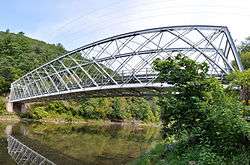 Panorama of the bridge in 2012 | |
  | |
| Location | PA 414 (LR 41022) over Pine Creek, Brown Township, Lycoming County, Pennsylvania |
|---|---|
| Coordinates | 41°29′11″N 77°29′50″W |
| Area | less than one acre |
| Built | 1890 |
| Architectural style | lattice truss |
| MPS | Highway Bridges Owned by the Commonwealth of Pennsylvania, Department of Transportation TR |
| NRHP reference No. | 88000844[1] |
| Added to NRHP | June 22, 1988 |
It was added to the National Register of Historic Places in 1988.[1]
Gallery
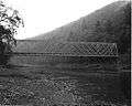 Bridge in Brown Township, 1982
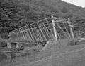 HAER photograph by Joseph Elliott, 1997
gollark: Or vickreyness.
gollark: We don't have sealed bids, though.
gollark: Interesting! Initiating viewing.
gollark: I *also* have 16lc, it's not much.
gollark: I don't have enough for that to be remotely viable.
References
- "National Register Information System". National Register of Historic Places. National Park Service. July 9, 2010.
- "National Historic Landmarks & National Register of Historic Places in Pennsylvania" (Searchable database). CRGIS: Cultural Resources Geographic Information System. Note: This includes unknown (1982). "National Register of Historic Places Inventory Nomination Form: Bridge in Brown Borough" (PDF). Retrieved 2011-11-18.
External links
- Historic American Engineering Record (HAER) No. PA-460, "Upper Bridge at Slate Run, Spanning Pine Creek at State Route 414, Slate Run, Lycoming County, PA", 8 photos, 5 measured drawings, 17 data pages, 1 photo caption page
- HAER No. PA-478, "Structural Study of Pennsylvania Historic Bridges, Pennsylvania Department of Transportation, Harrisburg, Dauphin County, PA", includes structural engineering analysis of Upper Bridge at Slate Run
| Topics |  | |
|---|---|---|
| Lists by county |
| |
| Lists by city |
| |
| Other lists | ||
| ||
This article is issued from Wikipedia. The text is licensed under Creative Commons - Attribution - Sharealike. Additional terms may apply for the media files.