Bholahat Upazila
Bholahat (Bengali: ভোলাহাট) is an Upazila of Nawabganj District in the Division of Rajshahi, Bangladesh.[1]
Bholahat ভোলাহাট | |
|---|---|
Upazila | |
 Bholahat Location in Bangladesh | |
| Coordinates: 24°56′45″N 88°13′40″E | |
| Country | |
| Division | Rajshahi Division |
| District | Chapai Nawabganj District |
| Area | |
| • Total | 123.52 km2 (47.69 sq mi) |
| Population (2011) | |
| • Total | 103,301 |
| • Density | 840/km2 (2,200/sq mi) |
| Time zone | UTC+6 (BST) |
| Website | Official Map of Bholahat |
Geography
Its total area of 123.52 km². The Indian border is surrounded on 3 sides by this Upazila. The Mahananda River, Bil Vatia and Mango garden divide this Upazila from India.
Bholahat Upazila is bounded by Old Malda CD Block in Malda district, West Bengal, India on the north, Habibpur CD Block in Malda district on the east, Shibganj and Gomostapur Upazilas on the south and English Bazar CD Block in Malda district, on the west.[2][3]
Demographics
According to 2011 Bangladesh census, Bholahat had a population of 103,301. Males constituted 49.40% of the population and females 50.60%. Muslims formed 99.13% of the population, Hindus 0.85% and others 0.02%. Bholahat had a literacy rate of 47.17% for the population 7 years and above.[4]
According to the 2001 Bangladesh census, Bholahat had a population of 92,149. Males constituted 50.58% of the population, and females 49.42%. There were 19,257 households. Bholahat had an average literacy rate of 39.22%, comprising a male literacy rate of 39.71% and female literacy rate of 38.74%.
Administration
Bholahat has 4 Unions/Wards, 45 Mauzas/Mahallas and 91 villages.
See also
- Upazilas of Bangladesh
- Districts of Bangladesh
- Divisions of Bangladesh
References
- Mazharul Islam Taru (2012), "Bholahat Upazila", in Sirajul Islam and Ahmed A. Jamal (ed.), Banglapedia: National Encyclopedia of Bangladesh (Second ed.), Asiatic Society of Bangladesh
- "Bholahat Upazila". Banglapedia. Retrieved 15 November 2018.
- "Tehsil Map of Maldah". CD Block/ Tehsil. Maps of India. Retrieved 15 November 2018.
- "Bangladesh Population and Housing Census 2011: Zila Report – Chapai Nawabganj" (PDF). Table P01 : Household and Population by Sex and Residence, Table P05 : Population by Religion, Age group and Residence, Table P09 : Literacy of Population 7 Years & Above by Religion, Sex and Residence. Bangladesh Bureau of Statistics (BBS), Ministry of Planning, Government of the People’s Republic of Bangladesh. Retrieved 9 December 2018.
External links
| Wikimedia Commons has media related to Bholahat Upazila. |
| Upazila/Thana: |
| |
|---|---|---|
Headquarters: Rajshahi | ||
| Bogra District | 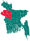 | |
| Joypurhat District | ||
| Naogaon District | ||
| Natore District | ||
| Nawabganj District | ||
| Pabna District | ||
| Rajshahi District | ||
| Sirajganj District | ||