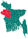
Baraigram Upazila
Baraigram (Bengali: বড়াইগ্রাম or Boraaigraam) is an Upazila of Natore District[1] in Rajshahi Division, Bangladesh.
Baraigram বড়াইগ্রাম | |
|---|---|
Upazila | |
 Baraigram Location in Bangladesh | |
| Coordinates: 24°18.5′N 89°10.2′E | |
| Country | |
| Division | Rajshahi Division |
| District | Natore District |
| Area | |
| • Total | 299.61 km2 (115.68 sq mi) |
| Population (1991) | |
| • Total | 230,480 |
| • Density | 770/km2 (2,000/sq mi) |
| Time zone | UTC+6 (BST) |
| Website | Official Map of Baraigram |
Geography
Baraigram is located at 24.3083°N 89.1708°E . It has 40582 households and total area 299.61 km².
Demographics
As of the 1991 Bangladesh census, Baraigram has a population of 230480. Males constitute 50.85% of the population, and females 49.15%. This Upazila's eighteen up population is 108842. Baraigram has an average literacy rate of 25.3% (7+ years), and the national average of 32.4% literate.[2]
Administration
Baraigram has 7 Unions/Wards, 152 Mauzas/Mahallas, and 179 villages. 1. No 1Joari union parishad. 2. 2No Baraigram Union Parishad. 3. No 4Jonail Union Parishad. 4. No 4Nagor union council. 5. Majgaon Union Parishad. 6 .Gopalpur Union Council. 7. 7th Chandai Union Parishad .
- Upazilas of Bangladesh
- Districts of Bangladesh
- Divisions of Bangladesh
References
- Md. Entaj Uddin (2012), "Baraigram Upazila", in Sirajul Islam and Ahmed A. Jamal (ed.), Banglapedia: National Encyclopedia of Bangladesh (Second ed.), Asiatic Society of Bangladesh
- "Population Census Wing, BBS". Archived from the original on 2005-03-27. Retrieved November 10, 2006.
