Illinois Route 32
Illinois Route 32 (IL 32) is a north–south highway with its southern terminus at U.S. Route 40 and Illinois Route 33 in Effingham and its northern terminus at Illinois Route 48 at Cisco, a few hundred feet south of Interstate 72. Illinois 32 is 69.32 miles (111.56 km) long.[1]
| ||||
|---|---|---|---|---|
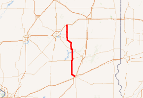
IL 32 highlighted in red | ||||
| Route information | ||||
| Maintained by IDOT | ||||
| Length | 69.32 mi[1] (111.56 km) | |||
| Existed | November 5, 1918[2]–present | |||
| Major junctions | ||||
| South end | ||||
| North end | ||||
| Location | ||||
| Counties | Effingham, Shelby, Moultrie, Piatt, Macon | |||
| Highway system | ||||
| ||||

Route description
Illinois 32 overlaps Illinois 33 from Shumway to Effingham, where Illinois 32 terminates and Illinois 33 continues east through Effingham to the Vincennes, Indiana area. Traveling north, Illinois 32 services Windsor, Sullivan, Lovington, and Cerro Gordo before reaching Cisco.
History
SBI Route 32 was established in 1918 from the Decatur area (actually Cerro Gordo) to Windsor. In 1936 it was extended to Effingham, and in January 1998, it was extended north to Illinois 48.
Major intersections
| County | Location | mi[3] | km | Destinations | Notes |
|---|---|---|---|---|---|
| Effingham | Effingham | 0.0 | 0.0 | Southern terminus; south end of IL 33 overlap | |
| 1.1 | 1.8 | I-57 exit 160 | |||
| | 4.8 | 7.7 | North end of IL 33 overlap | ||
| Shelby | | 21.4 | 34.4 | South end of IL 16 overlap | |
| Windsor | 23.9 | 38.5 | North end of IL 16 overlap | ||
| Moultrie | Sullivan | 35.5 | 57.1 | South end of IL 121 overlap | |
| | 36.9 | 59.4 | North end of IL 121 overlap | ||
| Lovington | 44.3 | 71.3 | Western terminus of IL 133 | ||
| Moultrie–Piatt county line | | 52.7 | 84.8 | ||
| Piatt | | 56.9 | 91.6 | South end of IL 105 overlap | |
| Cerro Gordo | 59.7 | 96.1 | North end of IL 105 overlap | ||
| Piatt–Macon county line | | 69.32 | 111.56 | Northern terminus | |
| Continuation beyond IL 48 | |||||
1.000 mi = 1.609 km; 1.000 km = 0.621 mi
| |||||
gollark: See, this is why I try to avoid running Google software on my device.
gollark: Apparently it has an effect on viral replication somehow.
gollark: As far as I know he isn't actually *in* China, just... talks about it sometimes?
gollark: Has the link and elected to join it, that is.
gollark: Modern computers can easily manage trillions of errors a second.
References
- Illinois Technology Transfer Center (2007). "T2 GIS Data". Retrieved 2007-11-08.
- Carlson, Rick. Illinois State Highways Page: Routes 21 thru 40. Last updated March 15, 2005. Retrieved April 1, 2006.
- Google Maps,
External links
This article is issued from Wikipedia. The text is licensed under Creative Commons - Attribution - Sharealike. Additional terms may apply for the media files.