Beaver Township, Iroquois County, Illinois
Beaver Township is one of twenty-six townships in Iroquois County, Illinois, USA. As of the 2010 census, its population was 527 and it contained 229 housing units.[2]
Beaver Township | |
|---|---|
 Location in Iroquois County | |
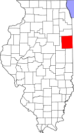
 Iroquois County's location in Illinois | |
| Coordinates: 40°54′00″N 87°35′19″W | |
| Country | United States |
| State | Illinois |
| County | Iroquois |
| Established | November 6, 1855 |
| Area | |
| • Total | 33.66 sq mi (87.2 km2) |
| • Land | 33.65 sq mi (87.2 km2) |
| • Water | 0.01 sq mi (0.03 km2) 0.03% |
| Elevation | 673 ft (205 m) |
| Population (2010) | |
| • Estimate (2016)[1] | 508 |
| • Density | 15.7/sq mi (6.1/km2) |
| Time zone | UTC-6 (CST) |
| • Summer (DST) | UTC-5 (CDT) |
| ZIP codes | 60912, 60931, 60970 |
| FIPS code | 17-075-04455 |
Geography
According to the 2010 census, the township has a total area of 33.66 square miles (87.2 km2), of which 33.65 square miles (87.2 km2) (or 99.97%) is land and 0.01 square miles (0.026 km2) (or 0.03%) is water.[2]
Cities, towns, villages
Unincorporated towns
- Hooper at 40.935867°N 87.606699°W
(This list is based on USGS data and may include former settlements.)
Cemeteries
The township contains these two cemeteries: Beaver and J H Grant Memorial.
Major highways
Airports and landing strips
- Loy Airport
- Russell Airport
School districts
- Donovan Community Unit School District 3
Political districts
- Illinois' 15th congressional district
- State House District 79
- State Senate District 40
gollark: I like the Botania "sash" things which let you walk faster too.
gollark: Botania has the Ring of Odin, which gives extra health and such, which is very cool and good if you can get it.
gollark: Never mind, I went to look at it now, and it has begun working inexplicably.
gollark: Why is my apiary not working? It has a dragon egg right beside it.
gollark: Just set that up and lure it near it without dying.
References
- "Beaver Township, Iroquois County, Illinois". Geographic Names Information System. United States Geological Survey. Retrieved 2010-01-17.
- United States Census Bureau 2007 TIGER/Line Shapefiles
- United States National Atlas
- "Population and Housing Unit Estimates". Retrieved June 9, 2017.
- "Population, Housing Units, Area, and Density: 2010 - County -- County Subdivision and Place -- 2010 Census Summary File 1". United States Census. Archived from the original on 2020-02-12. Retrieved 2013-05-28.
- "Census of Population and Housing". Census.gov. Retrieved June 4, 2016.
External links
This article is issued from Wikipedia. The text is licensed under Creative Commons - Attribution - Sharealike. Additional terms may apply for the media files.