Apollo Marine Park
The Apollo Marine Park (previously known as the Apollo Commonwealth Marine Reserve) is an Australian Marine Park located in Bass Strait off the coast of Victoria and near Tasmania's King Island. The marine park was established in 2007 and covers an area of 1,184 km2 (457 sq mi).[2] It is managed as part of the South-east Marine Parks Network.
| Apollo Marine Park | |
|---|---|
IUCN category VI (protected area with sustainable use of natural resources) | |
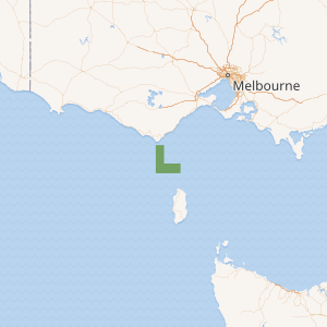
Map showing the Apollo Marine Park | |
| Location | Bass Strait, Australia |
| Nearest town | Apollo Bay, Victoria |
| Coordinates | 39.20°S 143.66°E[1] |
| Area | 1,184 km2 (457 sq mi) |
| Established | August 31, 2007 |
| Governing body | Parks Australia |
| parksaustralia | |
One of the reserve's features includes the Otway Depression, a 100 m deep undersea valley joining the Bass Basin to the open ocean. This valley was an outlet channel for the ancient Bass Lake and mainland river systems, which existed during the last ice age.[3]
Protection
The Apollo Marine Park has been assigned IUCN protected area category VI and is wholly zoned as 'Multiple Use'.[3]
The following table is a summary of the 'Multiple Use Zone' of the marine park:
| Zone | IUCN | Activities permitted | Area (km2) | |||||||||||||||||||||||||||||||||||||||||||||||||||||||||||||||||||||||||||||||||||||||||||||||
|---|---|---|---|---|---|---|---|---|---|---|---|---|---|---|---|---|---|---|---|---|---|---|---|---|---|---|---|---|---|---|---|---|---|---|---|---|---|---|---|---|---|---|---|---|---|---|---|---|---|---|---|---|---|---|---|---|---|---|---|---|---|---|---|---|---|---|---|---|---|---|---|---|---|---|---|---|---|---|---|---|---|---|---|---|---|---|---|---|---|---|---|---|---|---|---|---|---|---|
| Recreational fishing | Commercial fishing | Mining | ||||||||||||||||||||||||||||||||||||||||||||||||||||||||||||||||||||||||||||||||||||||||||||||||
| Multiple Use | VI | Yes | with approval | with approval | 1,184 | |||||||||||||||||||||||||||||||||||||||||||||||||||||||||||||||||||||||||||||||||||||||||||||
| [Note 1] | ||||||||||||||||||||||||||||||||||||||||||||||||||||||||||||||||||||||||||||||||||||||||||||||||||
Shipwrecks
The MS City of Rayville is located within the marine reserve near Cape Otway. It was the first American vessel sunk during World War II.
See also
Notes
- Summary of permitted activities only, see source for details[4]
References
- "Apollo Marine Park on OpenStreetMap". openstreetmap.org. © OpenStreetMap contributors. Retrieved 17 June 2017.
- "Collaborative Australian Protected Areas Database (CAPAD) 2014 - Marine". environment.gov.au. © Commonwealth of Australia. Retrieved 16 June 2017.
- "Apollo Commonwealth Marine Reserve". environment.gov.au. © Commonwealth of Australia. Retrieved 17 June 2017.
- "South-east Commonwealth Marine Reserves Network - Zoning and activities". environment.gov.au. © Commonwealth of Australia. Retrieved 16 June 2017.