Nelson Commonwealth Marine Reserve
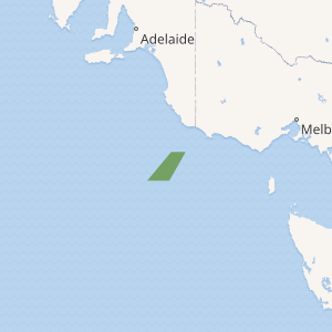
Nelson Commonwealth Marine Reserve is a 6,123 km2 marine protected area within Australian waters located in the Southern Ocean[2] near the South Australia-Victoria border. The reserve was established in 2007[3] and is part of the South-east Commonwealth Marine Reserve Network.
| Nelson Commonwealth Marine Reserve | |
|---|---|
IUCN category VI (protected area with sustainable use of natural resources) | |

Map showing the Nelson Commonwealth Marine Reserve | |
| Location | Indian Ocean, Australia |
| Nearest town | Port Macdonnell, South Australia |
| Coordinates | 39.31°S 139.85°E[1] |
| Area | 6,123 km2 (2,364 sq mi) |
| Established | August 31, 2007 |
| Governing body | Parks Australia (Commonwealth of Australia) |
| environment | |
The reserve spans deepwater ecosystems (below 3,000 m (9,800 ft)) and encloses geological features including plateaus, knolls, canyons and the abyssal plain. It is an important migration area for humpback, blue, fin and possibly sei whales.[4]
Protection
The entirety of the Nelson marine reserve area is IUCN protected area category VI and is zoned as 'Special Purpose'.[4]
| Zone | IUCN | Activities permitted | Area (km2) | |||||||||||||||||||||||||||||||||||||||||||||||||||||||||||||||||||||||||||||||||||||||||||||||
|---|---|---|---|---|---|---|---|---|---|---|---|---|---|---|---|---|---|---|---|---|---|---|---|---|---|---|---|---|---|---|---|---|---|---|---|---|---|---|---|---|---|---|---|---|---|---|---|---|---|---|---|---|---|---|---|---|---|---|---|---|---|---|---|---|---|---|---|---|---|---|---|---|---|---|---|---|---|---|---|---|---|---|---|---|---|---|---|---|---|---|---|---|---|---|---|---|---|---|
| Recreational fishing | Commercial fishing | Mining | ||||||||||||||||||||||||||||||||||||||||||||||||||||||||||||||||||||||||||||||||||||||||||||||||
| Special Purpose | VI | Yes | No | with approval | 6,123 | |||||||||||||||||||||||||||||||||||||||||||||||||||||||||||||||||||||||||||||||||||||||||||||
| [Note 1] | ||||||||||||||||||||||||||||||||||||||||||||||||||||||||||||||||||||||||||||||||||||||||||||||||||
gollark: jake: the power of *E B A Y*.
gollark: It's a type of frog found in the Amazon rainforest.
gollark: It's weird how these monitors' *stands* seem to be more expensive than these 1080p monitors...
gollark: *dislikes C and OOP*
gollark: I have *one*.
See also
- Commonwealth marine reserves
- Protected areas of Australia
- Great Australian Bight
Notes
- Summary of permitted activities only, see source for details[5]
References
- "Nelson Commonwealth Marine Reserve on OpenStreetMap". openstreetmap.org. © OpenStreetMap contributors. Retrieved 18 June 2017.
- See Southern Ocean and Indian Ocean regarding differing recognitions of the boundaries
- "Collaborative Australian Protected Areas Database (CAPAD) 2014 - Marine". environment.gov.au. © Commonwealth of Australia. Retrieved 16 June 2017.
- "Nelson Commonwealth Marine Reserve". environment.gov.au. © Commonwealth of Australia. Retrieved 18 June 2017.
- "South-east Commonwealth Marine Reserves Network - Zoning and activities". environment.gov.au. © Commonwealth of Australia. Retrieved 18 June 2017.
External links
This article is issued from Wikipedia. The text is licensed under Creative Commons - Attribution - Sharealike. Additional terms may apply for the media files.