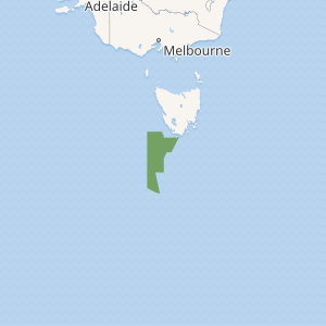
Tasman Fracture Commonwealth Marine Reserve
Tasman Fracture Commonwealth Marine Reserve is a 42,502 km2 marine protected area within Australian waters located off the coast of south-west Tasmania. It extends to the southerly limits of the Australian exclusive economic zone in the Indian Ocean and encompasses the Tasman Fracture. The reserve was established in 2007[2] and is part of the South-east Commonwealth Marine Reserve Network.
| Tasman Fracture Commonwealth Marine Reserve | |
|---|---|
IUCN category VI (protected area with sustainable use of natural resources) | |

| |
| Location | Indian Ocean, Australia |
| Nearest town | Melaleuca, Tasmania |
| Coordinates | 44.83°S 144.81°E[1] |
| Area | 42,501 km2 (16,410 sq mi) |
| Established | August 31, 2007 |
| Governing body | Parks Australia (Commonwealth of Australia) |
| environment | |
The reserve includes a number of undersea peaks rising to less than 1,500 m (4,900 ft) below the sea surface that provide habitat to deepwater hard corals. The reserve is also habitat to many seabirds, seals and cetaceans, such as dolphins and killer whales. The fauna of this reserve includes subantarctic fishes and seabed invertebrates. Biodiversity within the reserve is influenced by the most easterly extent of the Zeehan Current.[3]
Protection
Most of the Tasman Fracture marine reserve area is IUCN protected area category VI, however there are multiple zoned areas within the reserve with different protection classifications.[3]
| Zone | IUCN | Activities permitted | Area (km2) | |||||||||||||||||||||||||||||||||||||||||||||||||||||||||||||||||||||||||||||||||||||||||||||||
|---|---|---|---|---|---|---|---|---|---|---|---|---|---|---|---|---|---|---|---|---|---|---|---|---|---|---|---|---|---|---|---|---|---|---|---|---|---|---|---|---|---|---|---|---|---|---|---|---|---|---|---|---|---|---|---|---|---|---|---|---|---|---|---|---|---|---|---|---|---|---|---|---|---|---|---|---|---|---|---|---|---|---|---|---|---|---|---|---|---|---|---|---|---|---|---|---|---|---|
| Recreational fishing | Commercial fishing | Mining | ||||||||||||||||||||||||||||||||||||||||||||||||||||||||||||||||||||||||||||||||||||||||||||||||
| Marine National Park | II | No | No | No | 692 | |||||||||||||||||||||||||||||||||||||||||||||||||||||||||||||||||||||||||||||||||||||||||||||
| Special Purpose | VI | Yes | No | with approval | 21,313 | |||||||||||||||||||||||||||||||||||||||||||||||||||||||||||||||||||||||||||||||||||||||||||||
| Multiple Use | VI | Yes | with approval | with approval | 20 496 | |||||||||||||||||||||||||||||||||||||||||||||||||||||||||||||||||||||||||||||||||||||||||||||
| [Note 1] | ||||||||||||||||||||||||||||||||||||||||||||||||||||||||||||||||||||||||||||||||||||||||||||||||||
See also
- Commonwealth marine reserves
- Protected areas of Australia
- Southern Ocean
- Port Davey - nearby Tasmanian marine reserve within Southwest National Park
Notes
- Summary of permitted activities only, see source for details[4]
References
- "Tasman Fracture Commonwealth Marine Reserve on OpenStreetMap". openstreetmap.org. © OpenStreetMap contributors. Retrieved 19 June 2017.
- "Collaborative Australian Protected Areas Database (CAPAD) 2014 - Marine". environment.gov.au. © Commonwealth of Australia. Retrieved 16 June 2017.
- "Tasman Fracture Commonwealth Marine Reserve". environment.gov.au. © Commonwealth of Australia. Retrieved 19 June 2017.
- "South-east Commonwealth Marine Reserves Network - Zoning and activities". environment.gov.au. © Commonwealth of Australia. Retrieved 19 June 2017.