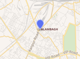
Alambagh metro station
Alambagh is an elevated metro station located on the Red Line of Lucknow Metro in the city of Lucknow Uttar Pradesh.[1]
Alambagh | |||||||||||
|---|---|---|---|---|---|---|---|---|---|---|---|
| Lucknow Metro station | |||||||||||
| Location | Railway Colony, Alambagh, Lucknow, Uttar Pradesh 226005 | ||||||||||
| Coordinates | 26°48′50″N 80°54′08″E | ||||||||||
| Owned by | Lucknow Metro | ||||||||||
| Operated by | Lucknow Metro Rail Corporation | ||||||||||
| Line(s) | Red Line (Lucknow Metro) | ||||||||||
| Platforms | Side platform
Platform-1 → Munshi Pulia Platform-2 → C C S Airport | ||||||||||
| Tracks | 2 | ||||||||||
| Construction | |||||||||||
| Structure type | Elevated, Double Track | ||||||||||
| Platform levels | 2 | ||||||||||
| Disabled access | Yes | ||||||||||
| Other information | |||||||||||
| Status | Staffed | ||||||||||
| History | |||||||||||
| Opened | 6 September 2017 | ||||||||||
| Electrified | Single phase 25 kV, 50 Hz AC through overhead catenary | ||||||||||
| Services | |||||||||||
| |||||||||||
History
Structure
| Alambagh metro station | |
|---|---|
आलम बाग़ | |
 Lucknow Metro Logo | |

| |
| General information | |
| Status | Complete |
| Type | Railway station |
| Location | Alambagh, Lucknow |
| Town or city | Lucknow |
| Country | |
| Coordinates | 26°48′50″N 80°54′08″E |
| Construction started | 2014 |
| Completed | 2017 |
| Opened | 6 September 2017 |
| Inaugurated | 5 September 2017 |
| Technical details | |
| Floor count | 2 |
| Lifts/elevators | 2 |
| Design and construction | |
| Main contractor | Larsen & Toubro |
| Website | |
| www.lmrcl.com | |
Station layout
Alambagh track layout | ||||||||||||||||||||||||||||||||||||||||||
|---|---|---|---|---|---|---|---|---|---|---|---|---|---|---|---|---|---|---|---|---|---|---|---|---|---|---|---|---|---|---|---|---|---|---|---|---|---|---|---|---|---|---|
| ||||||||||||||||||||||||||||||||||||||||||
Station with two tracks and two side platforms | ||||||||||||||||||||||||||||||||||||||||||
| G | Street Level | Exit/Entrance |
| L1 | Mezzanine | Fare control, station agent, Metro Card vending machines, crossover |
| L2 | Side platform No- 1, doors will open on the left | |
| Northbound | Towards →Munshi Pulia | |
| Southbound | →Towards ←C C S Airport | |
| Side platform No- 2, doors will open on the left | ||
| L2 | ||
Connections
Entry/Exit
Gallery
Route plan/map
| Lucknow Metro Railway | ||||||||||||||||||||||||||||||||||||||||||||||||||||||||||||||||||||||||||||||||||||||||||||||||||||||||||||||||||||||||||||||||||||||||||||||||||||||||||||||||||||||||||||||||||||||||||||||||||||||||||||||||||||||||||||||||||||||||||||||||||||||||||||||||||||||||||||||||||||||||||||||||||||||||||||||||||||||||||||||||||||||||||||||||||||||||||||||||||||||||||||||||||||||||||||||||||||||||||||||||||||||||||||||||||||||||||||||||||||||||||||||||||||||||||||||||||||||||||||||||||||||||||||||||||||||||||||||
|---|---|---|---|---|---|---|---|---|---|---|---|---|---|---|---|---|---|---|---|---|---|---|---|---|---|---|---|---|---|---|---|---|---|---|---|---|---|---|---|---|---|---|---|---|---|---|---|---|---|---|---|---|---|---|---|---|---|---|---|---|---|---|---|---|---|---|---|---|---|---|---|---|---|---|---|---|---|---|---|---|---|---|---|---|---|---|---|---|---|---|---|---|---|---|---|---|---|---|---|---|---|---|---|---|---|---|---|---|---|---|---|---|---|---|---|---|---|---|---|---|---|---|---|---|---|---|---|---|---|---|---|---|---|---|---|---|---|---|---|---|---|---|---|---|---|---|---|---|---|---|---|---|---|---|---|---|---|---|---|---|---|---|---|---|---|---|---|---|---|---|---|---|---|---|---|---|---|---|---|---|---|---|---|---|---|---|---|---|---|---|---|---|---|---|---|---|---|---|---|---|---|---|---|---|---|---|---|---|---|---|---|---|---|---|---|---|---|---|---|---|---|---|---|---|---|---|---|---|---|---|---|---|---|---|---|---|---|---|---|---|---|---|---|---|---|---|---|---|---|---|---|---|---|---|---|---|---|---|---|---|---|---|---|---|---|---|---|---|---|---|---|---|---|---|---|---|---|---|---|---|---|---|---|---|---|---|---|---|---|---|---|---|---|---|---|---|---|---|---|---|---|---|---|---|---|---|---|---|---|---|---|---|---|---|---|---|---|---|---|---|---|---|---|---|---|---|---|---|---|---|---|---|---|---|---|---|---|---|---|---|---|---|---|---|---|---|---|---|---|---|---|---|---|---|---|---|---|---|---|---|---|---|---|---|---|---|---|---|---|---|---|---|---|---|---|---|---|---|---|---|---|---|---|---|---|---|---|---|---|---|---|---|---|---|---|---|---|---|---|---|---|---|---|---|---|---|---|---|---|---|---|---|---|---|---|---|---|---|---|---|---|---|---|---|---|---|---|---|---|---|---|---|---|---|---|---|---|---|---|---|---|---|---|---|---|---|---|---|---|---|---|---|---|---|---|---|---|---|---|---|---|---|---|---|---|---|---|---|---|---|---|---|---|---|---|---|---|---|---|---|---|---|---|---|---|---|---|---|---|---|---|---|---|---|---|---|---|---|---|---|---|---|---|---|---|---|---|---|---|---|
| ||||||||||||||||||||||||||||||||||||||||||||||||||||||||||||||||||||||||||||||||||||||||||||||||||||||||||||||||||||||||||||||||||||||||||||||||||||||||||||||||||||||||||||||||||||||||||||||||||||||||||||||||||||||||||||||||||||||||||||||||||||||||||||||||||||||||||||||||||||||||||||||||||||||||||||||||||||||||||||||||||||||||||||||||||||||||||||||||||||||||||||||||||||||||||||||||||||||||||||||||||||||||||||||||||||||||||||||||||||||||||||||||||||||||||||||||||||||||||||||||||||||||||||||||||||||||||||||
gollark: 0/10 you're a go user
gollark: 0/10 no locals.
gollark: Advanced obfuscation techniques.
gollark: I mostly just minify, which is designed to shorten the code but does obfuscate well.
gollark: Actually, it's just various other libraries minified together with a teeny bit of unreadable minified code which actually runs which I edit in minified form at the end.
See also
- Lucknow
- List of Lucknow Metro stations
- Uttar Pradesh State Road Transport Corporation
- List of rapid transit systems in India
- List of Metro Systems
References
- "Lucknow Metro System's Line-1 Inaugurated". Retrieved 6 September 2017.
- "City of Nawabs prepares for 'Life in a Metro'". Rail News. Retrieved 24 July 2014.
- Khan, M Tariq (6 August 2013). "Proposed Lucknow Metro Stations on North-South and East-West Corridors". Hindustan Times. Retrieved 24 July 2014.
External links
| Wikimedia Commons has media related to Lucknow Metro. |
| Wikivoyage has a travel guide for Lucknow. |
- website
- Google. "Alambagh metro station" (Map). Google Maps. Google.
- UrbanRail.Net – descriptions of all metro systems in the world, each with a schematic map showing all stations.
This article is issued from Wikipedia. The text is licensed under Creative Commons - Attribution - Sharealike. Additional terms may apply for the media files.
