AH30
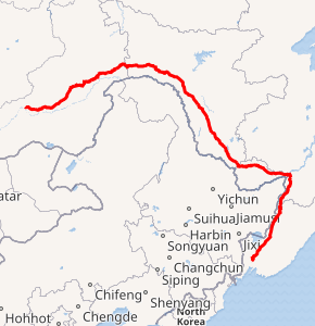
Asian Highway 30 or AH30 is a route located in Russia, running 2,785 kilometres (1,731 mi) from Ussuriysk, Primorsky Krai to Chita, Zabaykalsky Krai.[1][2] Khabarovsk to Chita section of this Asian highway is named after Amur river as Amur Highway .
| ||||
|---|---|---|---|---|

AH30 in red | ||||
Khabarovsk Bridge over Amur River on AH30 | ||||
| Route information | ||||
| Length | 2,785 km (1,731 mi) | |||
| Major junctions | ||||
| South end | Ussuriysk, Primorsky Krai | |||
| North end | Chita, Zabaykalsky Krai | |||
| Highway system | ||||
Russian Federal Highways
| ||||
Route

Amur Highway in Bureysky District


Junctions


gollark: Coral Shoe Transfer Protocol when?
gollark: Apiohypnoforms inbound.
gollark: As planned.
gollark: Are you ”””enjoying⅛⅛⅛⅛⅛ awesome?
gollark: Why use the Discord app when you could use W E B D I S C O R D by osmarks.tk™?
See also
References
- "Asian Highway Handbook" (PDF). New York. 2003. Retrieved 16 December 2014.
- "Asian Highway Route Map" (PDF). Economic and Social Commission for Asia and the Pacific. Retrieved 16 December 2018.
- "Asian Highway Database - Country wise". UNESCAP. Retrieved 16 December 2018.
- "Asian Highway route map in Russia" (PDF). UNESCAP. Retrieved 16 December 2018.
This article is issued from Wikipedia. The text is licensed under Creative Commons - Attribution - Sharealike. Additional terms may apply for the media files.

