Washingtonville, Ohio
Washingtonville is a village in Columbiana and Mahoning counties in the U.S. state of Ohio. The population was 801 at the 2010 census. Southern Washingtonville is included in the Salem, OH Micropolitan Statistical Area, while northern Washingtonville is part of the Youngstown-Warren-Boardman, OH-PA Metropolitan Statistical Area.
Washingtonville, Ohio | |
|---|---|
| Village of Washingtonville | |
 Houses on Market Street | |
 Location of Washingtonville in Columbiana County and the State of Ohio | |
| Coordinates: 40°53′55″N 80°45′52″W | |
| Country | United States |
| State | Ohio |
| Counties | Columbiana, Mahoning |
| Government | |
| • Type | Mayor-Council |
| • Mayor | Herman C. Frank II (I)[1] |
| Area | |
| • Total | 0.67 sq mi (1.73 km2) |
| • Land | 0.67 sq mi (1.73 km2) |
| • Water | 0.00 sq mi (0.00 km2) |
| Population | |
| • Total | 801 |
| • Estimate (2019)[4] | 750 |
| • Density | 1,122.75/sq mi (433.22/km2) |
| Time zone | UTC-5 (Eastern (EST)) |
| • Summer (DST) | UTC-4 (EDT) |
| ZIP code | 44490 |
| Area code(s) | 234/330 |
| FIPS code | 39-81732 |
| School District | Leetonia Exempted Village |
History
Washingtonville was laid out in 1832, and the first hotel was built there in 1833.[5] Washingtonville was incorporated in 1844.[6]
Geography
Washingtonville is located at 40°53′55″N 80°45′52″W (40.898603, -80.764419).[7]
According to the United States Census Bureau, the village has a total area of 0.67 square miles (1.74 km2), all land.[8]
Demographics
| Historical population | |||
|---|---|---|---|
| Census | Pop. | %± | |
| 1880 | 958 | — | |
| 1900 | 1,092 | — | |
| 1910 | 957 | −12.4% | |
| 1920 | 823 | −14.0% | |
| 1930 | 816 | −0.9% | |
| 1940 | 836 | 2.5% | |
| 1950 | 848 | 1.4% | |
| 1960 | 810 | −4.5% | |
| 1970 | 747 | −7.8% | |
| 1980 | 865 | 15.8% | |
| 1990 | 894 | 3.4% | |
| 2000 | 789 | −11.7% | |
| 2010 | 801 | 1.5% | |
| Est. 2019 | 750 | [4] | −6.4% |
| U.S. Decennial Census[9] | |||
2010 census
As of the census[3] of 2010, there were 801 people, 323 households, and 225 families living in the village. The population density was 1,195.5 inhabitants per square mile (461.6/km2). There were 358 housing units at an average density of 534.3 per square mile (206.3/km2). The racial makeup of the village was 98.0% White, 0.9% African American, 0.1% from other races, and 1.0% from two or more races. Hispanic or Latino of any race were 0.5% of the population.
There were 323 households, of which 32.2% had children under the age of 18 living with them, 43.0% were married couples living together, 19.5% had a female householder with no husband present, 7.1% had a male householder with no wife present, and 30.3% were non-families. 24.5% of all households were made up of individuals, and 10.2% had someone living alone who was 65 years of age or older. The average household size was 2.48 and the average family size was 2.92.
The median age in the village was 37.5 years. 24.7% of residents were under the age of 18; 9.3% were between the ages of 18 and 24; 24.3% were from 25 to 44; 27.9% were from 45 to 64; and 13.7% were 65 years of age or older. The gender makeup of the village was 48.7% male and 51.3% female.
2000 census
As of the census[10] of 2000, there were 789 people, 314 households, and 227 families living in the village. The population density was 1,179.6 people per square mile (454.7/km2). There were 327 housing units at an average density of 488.9 per square mile (188.4/km2). The racial makeup of the village was 98.23% White, 0.13% African American, 0.25% Native American, 0.38% from other races, and 1.01% from two or more races. Hispanic or Latino of any race were 0.63% of the population.
There were 314 households, out of which 35.4% had children under the age of 18 living with them, 48.4% were married couples living together, 17.8% had a female householder with no husband present, and 27.4% were non-families. 22.9% of all households were made up of individuals, and 7.6% had someone living alone who was 65 years of age or older. The average household size was 2.51 and the average family size was 2.91.
In the village, the population was spread out, with 26.0% under the age of 18, 10.4% from 18 to 24, 25.9% from 25 to 44, 25.1% from 45 to 64, and 12.7% who were 65 years of age or older. The median age was 38 years. For every 100 females there were 93.9 males. For every 100 females age 18 and over, there were 88.4 males.
The median income for a household in the village was $29,219, and the median income for a family was $29,167. Males had a median income of $30,625 versus $20,982 for females. The per capita income for the village was $13,061. About 20.4% of families and 19.9% of the population were below the poverty line, including 36.5% of those under age 18 and 5.7% of those age 65 or over.
References
- "2019 General Election Results for Columbiana County". Retrieved December 19, 2019.
- "2019 U.S. Gazetteer Files". United States Census Bureau. Retrieved July 28, 2020.
- "U.S. Census website". United States Census Bureau. Retrieved 2013-01-06.
- "Population and Housing Unit Estimates". Retrieved May 21, 2020.
- McCord, William B. (1905). History of Columbiana County, Ohio and Representative Citizens. Biographical Publishing Company. p. 329.
- Mack, Horace (1879). History of Columbiana County, Ohio: With Illustrations and Biographical Sketches of Some of Its Prominent Men and Pioneers. Unigraphic. p. 246.
- "US Gazetteer files: 2010, 2000, and 1990". United States Census Bureau. 2011-02-12. Retrieved 2011-04-23.
- "US Gazetteer files 2010". United States Census Bureau. Retrieved 2013-01-06.
- "Census of Population and Housing". Census.gov. Retrieved June 4, 2015.
- "U.S. Census website". United States Census Bureau. Retrieved 2008-01-31.
Municipalities and communities of Columbiana County, Ohio, United States | ||
|---|---|---|
| Cities | 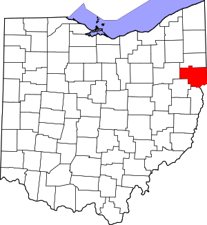 Map of Ohio highlighting Columbiana County | |
| Villages | ||
| Townships | ||
| CDPs | ||
| Unincorporated communities |
| |
| Ghost town | ||
| Footnotes | ‡This populated place also has portions in an adjacent county or counties | |
Municipalities and communities of Mahoning County, Ohio, United States | ||
|---|---|---|
| Cities | 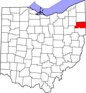 Map of Ohio highlighting Mahoning County | |
| Villages | ||
| Townships | ||
| CDPs | ||
| Unincorporated communities |
| |
| Footnotes | ‡This populated place also has portions in an adjacent county or counties | |
| Authority control |
|
|---|