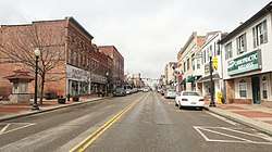
Salem, Ohio
Salem is a city almost entirely in northern Columbiana County, Ohio, United States, with a small district in southern Mahoning County. At the 2010 census, the city's population was 12,303.[8] Salem is the principal city of the Salem, OH Micropolitan Statistical Area, although the small portion of the city that extends into Mahoning County is considered part of the Youngstown-Warren-Boardman, OH-PA Metropolitan Statistical Area.[9] Salem is 25 miles (40 km) southwest of Youngstown and 30 miles (48 km) east of Canton.
Salem, Ohio | |
|---|---|
City | |
| City of Salem | |
 | |
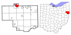 Location of Salem in Columbiana County and in the State of Ohio | |
| Coordinates: 40°54′3″N 80°51′10″W | |
| Country | United States |
| State | Ohio |
| Counties | Columbiana, Mahoning[1] |
| Government | |
| • Type | Statutory |
| • Mayor | John C. Berlin (R)[2] |
| • Council President | Thomas F. Baker (R)[2] |
| Area | |
| • Total | 6.43 sq mi (16.65 km2) |
| • Land | 6.42 sq mi (16.64 km2) |
| • Water | 0.00 sq mi (0.01 km2) |
| Elevation | 1,227 ft (374 m) |
| Population | |
| • Total | 12,303 |
| • Estimate (2019)[6] | 11,612 |
| • Density | 1,807.60/sq mi (697.90/km2) |
| Time zone | UTC-5 (EST) |
| • Summer (DST) | UTC-4 (EDT) |
| ZIP code | 44460 |
| Area code(s) | 330, 234 |
| FIPS code | 39-69834[7] |
| GNIS feature ID | 1045870[4] |
| School District | Salem City |
| Website | www.cityofsalemohio.org |
Founded by the Quaker society in 1806, Salem was notably active in the abolitionist movement of the early- to mid-19th century as a hub for the American Underground Railroad. Through the 20th century, Salem served as one of many industrial towns in the Mahoning Valley. Today, the city enjoys being an exurb of Youngstown and is the commercial hub of northwestern Columbiana County, home to Allegheny Wesleyan College and Kent State University at Salem.
History
Early history
Salem was founded by a Pennsylvanian potter, John Straughan, and a New Jersey clockmaker, Zadok Street, in 1806. The name Salem was taken from "Jerusalem", which means "city of peace".[10]
Early settlers to the city included the Religious Society of Friends ("Quakers"), which the school system's sports teams honor by referring to themselves collectively as the "Quakers."[11][12]
Salem was incorporated in 1830.[13]
Over its history, Salem thrived on an industrial-based economy, advantageously located between Cleveland and Pittsburgh. For several decades, the largest corporations located in Salem included American Standard Brands, Eljer, Mullins Manufacturing, Deming Pump, and Salem China. Today, American Standard, Fresh Mark, Inc. (a meat production facility) and several tool-and-die manufacturers remain.
Contributions to American history
Salem was a center for reform activity in several ways. The Anti-Slavery Bugle, an abolitionist newspaper, was published in Salem beginning in 1845.[14] A local group of the Progressive Friends, an association of Quakers who separated from the main body partly so they could be freer to work for such causes as abolitionism and women's rights, was formed in Salem in 1849.[15] The local school board at that time was composed entirely of abolitionists.[16]
In April 1850, Salem hosted the first Women's Rights Convention in Ohio, the third such convention in the United States. (The first was the Seneca Falls Convention of 1848; the second was the Rochester Convention two weeks later.) The Salem Convention was the first of these conventions to be organized on a statewide basis.[17] All of the convention's officers were women. Men were not allowed to vote, sit on the platform or speak during the convention. The male spectators were supportive, however, and when the convention was over, they created an organization of their own and endorsed the actions of the women's convention.[18]
While radio DJ Alan Freed was born in Johnstown, Pennsylvania, he grew up in Salem. While working at a radio station in Cleveland, he coined the phrase "Rock & Roll."
Historic districts
Two sections of the city are designated National Register historic districts: the "Salem Downtown Historic District" (bounded by Vine Avenue, Ohio Avenue, East Pershing Street, South Ellsworth Avenue, and Sugar Tree Alley, designated 1995), and the "South Lincoln Avenue Historic District" (designated 1993), which includes several of the town's monumental and architecturally distinctive homes.
Other city properties listed on the National Register of Historic Places include: the Burchfield Homestead (home to Charles Burchfield from ages five to twenty-eight), Daniel Howell Hise House (home of local Quaker abolitionist and Underground Railroad station), the (Former) Salem Methodist Episcopal Church|First United Methodist Church of Salem, and the John Street House (Underground Railroad station and home to descendant of city founder).
Geography
Salem is located at 40°54′3″N 80°51′10″W (40.900885, −80.852831).[19]
The following highways pass through Salem:
According to the United States Census Bureau, the city has a total area of 6.43 square miles (16.65 km2), all land.[20] Salem is the largest incorporated place by area in Columbiana County.
The city of Salem is mostly (see map) surrounded by Perry Township. As with other townships in Ohio,[21] Perry Township has been subject to annexation in recent years.[22][23] Residents of land annexed to the city of Salem enjoy all benefits other residents of the city enjoy, and by Ohio law[24] are now themselves residents of the city of Salem.
Several acres of Salem Township and Green Township were annexed into the city limits in 2000 and 2001. Other actions to spur economic development undertaken around the same time annexed specific land: in 1999, 82.24 acres (332,800 m2) of Salem Township were granted police and fire protection, snow removal service, and other standard services already provided to the City of Salem by Ordinance passed by the city government.[25]
Demographics
| Historical population | |||
|---|---|---|---|
| Census | Pop. | %± | |
| 1840 | 233 | — | |
| 1850 | 842 | 261.4% | |
| 1860 | 1,889 | 124.3% | |
| 1870 | 3,700 | 95.9% | |
| 1880 | 4,041 | 9.2% | |
| 1890 | 5,780 | 43.0% | |
| 1900 | 7,582 | 31.2% | |
| 1910 | 8,943 | 18.0% | |
| 1920 | 10,305 | 15.2% | |
| 1930 | 10,622 | 3.1% | |
| 1940 | 12,301 | 15.8% | |
| 1950 | 12,754 | 3.7% | |
| 1960 | 13,854 | 8.6% | |
| 1970 | 14,186 | 2.4% | |
| 1980 | 12,865 | −9.3% | |
| 1990 | 12,233 | −4.9% | |
| 2000 | 12,197 | −0.3% | |
| 2010 | 12,303 | 0.9% | |
| Est. 2019 | 11,612 | [6] | −5.6% |
| [7][26][27][28] | |||
2010 census
As of the census[5] of 2010, there were 12,303 people, 5,272 households, and 3,118 families living in the city. The population density was 1,913.4 inhabitants per square mile (738.8/km2). There were 5,763 housing units at an average density of 896.3 per square mile (346.1/km2). The racial makeup of the city was 95.9% White, 0.7% African American, 0.2% Native American, 0.4% Asian, 1.6% from other races, and 1.2% from two or more races. Hispanic or Latino of any race were 2.5% of the population.
There were 5,272 households, of which 26.3% had children under the age of 18 living with them, 41.5% were married couples living together, 12.3% had a female householder with no husband present, 5.3% had a male householder with no wife present, and 40.9% were non-families. 34.9% of all households were made up of individuals, and 15.9% had someone living alone who was 65 years of age or older. The average household size was 2.25 and the average family size was 2.87.
The median age in the city was 42.8 years. 21.2% of residents were under the age of 18; 7.7% were between the ages of 18 and 24; 23.6% were from 25 to 44; 28.3% were from 45 to 64; and 19.1% were 65 years of age or older. The gender makeup of the city was 47.9% male and 52.1% female.
2000 census
As of the census[7] of 2000, there were 12,197 people, 5,146 households, and 3,247 families living in the city. The population density was 2,228.2 people per square mile (860.9/km2). There were 5,505 housing units at an average density of 1,005.7 per square mile (388.6/km2). The racial makeup of the city was 98.35% White, 0.52% African American, 0.09% Native American, 0.34% Asian, 0.02% Pacific Islander, 0.08% from other races, and 0.59% from two or more races. Hispanic or Latino of any race were 0.54% of the population.
There were 5,146 households, out of which 28.1% had children under the age of 18 living with them, 48.7% were married couples living together, 10.6% had a female householder with no husband present, and 36.9% were non-families. 32.8% of all households were made up of individuals, and 17.1% had someone living alone who was 65 years of age or older. The average household size was 2.31 and the average family size was 2.92.
In the city the population was spread out, with 22.8% under the age of 18, 8.1% from 18 to 24, 27.4% from 25 to 44, 21.6% from 45 to 64, and 20.1% who were 65 years of age or older. The median age was 40 years. For every 100 females, there were 84.9 males. For every 100 females age 18 and over, there were 81.0 males.
The median income for a household in the city was $30,006, and the median income for a family was $40,191. Males had a median income of $31,630 versus $19,471 for females. The per capita income for the city was $16,579. About 9.8% of families and 11.7% of the population were below the poverty line, including 17.9% of those under age 18 and 9.8% of those age 65 or over.
Schools
Primary and secondary
Salem is served by the Salem City School District. The current schools operated by the district are:
- Buckeye Elementary School – 1200 Buckeye Avenue, grades K-2
- Reilly Elementary School – 491 Reilly Avenue, grades 3–4
- Southeast Elementary School – 2200 Merle Road, grades 5–6
- Salem Junior High School – 1200 E 6th Street, grades 7–8
- Salem High School – 1200 E 6th Street, grades 9–12
Alternatively, the Roman Catholic Diocese of Youngstown operates the St. Paul Elementary School.
Postsecondary
Allegheny Wesleyan College (AWC) is a private four-year liberal arts college in Salem, Ohio.[29][30]
Kent State University operates a satellite campus, Kent State University at Salem, with one building in the city proper and another just outside of city limits in Salem Township.
Notable people
- Chalkley Beeson – businessman, musician, lawman, and owner of Long Branch Saloon
- Charles Burchfield – 20th-century painter and visionary artist
- John Allen Campbell – first Governor of the Wyoming Territory
- Jason Candle – NCAA football coach for the Toledo Rockets
- Max Fisher – businessman and philanthropist, served as an advisor to U.S. Presidents for Israeli connections
- Alan Freed – disc jockey, coined the term "rock and roll"
- Rich Karlis – National Football League placekicker for the Denver Broncos, Minnesota Vikings, and Detroit Lions
- Kirk Lowdermilk – National Football League center for the Minnesota Vikings and Indianapolis Colts
- Jerry Meals – Major League Baseball umpire
- Jerri Nielsen – physician who administered a biopsy and chemotherapy to herself in Antarctica
- Webster Street – lawyer who served as Chief Justice of the Arizona Territorial Supreme Court
- Charles C. Williamson – librarian
- Lloyd Yoder – NCAA football tackle for the Carnegie Tech Tartans and College Football Hall of Fame inductee
References
- County Maps, State of Ohio (from Ohio Department of Transportation) http://www.dot.state.oh.us/map1/ohiomap/images/county/col.jpg Archived February 8, 2007, at the Wayback Machine, and Mahoning County map http://gis.mahoningcountyoh.gov/gis/asp.htm Archived July 21, 2008, at the Wayback Machine. See also http://www.mahoningcountyoh.gov
- "2019 General Election Results for Columbiana County". Retrieved December 19, 2019.
- "2019 U.S. Gazetteer Files". United States Census Bureau. Retrieved July 28, 2020.
- "US Board on Geographic Names". United States Geological Survey. October 25, 2007. Retrieved January 31, 2008.
- "U.S. Census website". United States Census Bureau. Retrieved January 6, 2013.
- "Population and Housing Unit Estimates". Retrieved May 21, 2020.
- "U.S. Census website". United States Census Bureau. Retrieved January 31, 2008.
- "Archived copy". Archived from the original on June 24, 2012. Retrieved July 13, 2012.CS1 maint: archived copy as title (link)
- "COMBINED STATISTICAL AREAS AND COMPONENT CORE BASED STATISTICAL AREAS, November 2008, WITH CODES". August 2009. Retrieved September 25, 2009.
- "Archived copy". Archived from the original on July 24, 2014. Retrieved July 26, 2014.CS1 maint: archived copy as title (link)
- The girls' and boys' teams' individual mascots are known as the "Quaker Lady" (or "Quaker Sadie") and "Quaker Sam," respectively.
- The team nickname (and, possibly, the American tradition of placing the word "Fighting" in front of such nicknames) was noted by USA Today as one of several "that could be considered offensive." See "What's in a Nickname?" USA Today, October 23, 1991, Sports section, 06C.
- Mack, Horace (1879). History of Columbiana County, Ohio: With Illustrations and Biographical Sketches of Some of Its Prominent Men and Pioneers. Unigraphic. p. 208.
- Anti-Slavery Bugle, Chronicling America: Historic American Newspapers." Library of Congress.
- Thomas, Allen C., (November 1920). "Congregational or Progressive Friends." Bulletin of Friends' Historical Society of Philadelphia, Vol. 10, No. 1. p. 28.
- Isenberg (1998), p. 216.
- Wellman, Judith (2008). "The Seneca Falls Women's Rights Convention and the Origin of the Women's Rights Movement", pp. 15, 84. National Park Service, Women's Rights National Historical Park. Wellman is identified as the author of this document here.
- Stanton, Elizabeth Cady; Anthony, Susan B.; Gage, Matilda Joslyn (1881). History of Woman Suffrage, p. 110. Volume 1 of 6. Rochester, NY: Susan B. Anthony (Charles Mann Press).
- "US Gazetteer files: 2010, 2000, and 1990". United States Census Bureau. February 12, 2011. Retrieved April 23, 2011.
- "US Gazetteer files 2010". United States Census Bureau. Archived from the original on July 2, 2012. Retrieved January 6, 2013.
- "Annexation law changes stretch too far". Business Courier of Cincinnati. July 19, 1996. Retrieved July 26, 2008.
- "Ordinance No. 990316-28". The City of Salem, Ohio. Archived from the original on August 19, 2008. Retrieved July 26, 2008.
- "Ordinance No. 000118-07". The City of Salem, Ohio. Archived from the original on August 19, 2008. Retrieved July 26, 2008.
- "City of Massillon Annexation Answer Page". 1998. Archived from the original on June 13, 2008. Retrieved July 26, 2008.
- This is understood to cover the area including the Wal-Mart Supercenter. See: ORDINANCE NO. 991103 – 74 Archived September 27, 2007, at the Wayback Machine, City of Salem
- "Population: Ohio" (PDF). 1930 US Census. U.S. Census Bureau. Retrieved November 28, 2013.
- "Number of Inhabitants: Ohio" (PDF). 18th Census of the United States. U.S. Census Bureau. 1960. Retrieved May 17, 2020.
- "Ohio: Population and Housing Unit Counts" (PDF). U.S. Census Bureau. Retrieved May 17, 2020.
- Colleges in the Midwest. Peterson's. 2009. ISBN 9780768926903.
- The College Board College Handbook. College Board. 2009.
External links
| Wikimedia Commons has media related to Salem, Ohio. |
| Wikisource has the text of a 1911 Encyclopædia Britannica article about Salem, Ohio. |
- City website
- http://www.SODCenter.com Economic Development website
- Salem Public Library
- Salem Chamber of Commerce
- Salem A Quaker City History
Municipalities and communities of Columbiana County, Ohio, United States | ||
|---|---|---|
| Cities |  Map of Ohio highlighting Columbiana County | |
| Villages | ||
| Townships | ||
| CDPs | ||
| Unincorporated communities |
| |
| Ghost town | ||
| Footnotes | ‡This populated place also has portions in an adjacent county or counties | |
Municipalities and communities of Mahoning County, Ohio, United States | ||
|---|---|---|
| Cities |  Map of Ohio highlighting Mahoning County | |
| Villages | ||
| Townships | ||
| CDPs | ||
| Unincorporated communities |
| |
| Footnotes | ‡This populated place also has portions in an adjacent county or counties | |
| Authority control |
|
|---|