Vineuil, Loir-et-Cher
Vineuil (French pronunciation: [vinœj]) is a commune near Blois, in the Loir-et-Cher department in Centre Region, France.
Vineuil | |
|---|---|
Commune | |
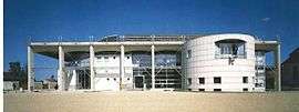 Town hall | |
.svg.png) Coat of arms | |
Location of Vineuil 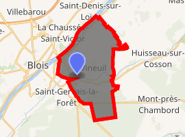
| |
 Vineuil  Vineuil | |
| Coordinates: 47°34′53″N 1°22′24″E | |
| Country | France |
| Region | Centre-Val de Loire |
| Department | Loir-et-Cher |
| Arrondissement | Blois |
| Canton | Vineuil |
| Intercommunality | Communauté d'agglomération de Blois |
| Government | |
| • Mayor (2014–2020) | François Fromet |
| Area 1 | 22.34 km2 (8.63 sq mi) |
| Population (2017-01-01)[1] | 7,815 |
| • Density | 350/km2 (910/sq mi) |
| Time zone | UTC+01:00 (CET) |
| • Summer (DST) | UTC+02:00 (CEST) |
| INSEE/Postal code | 41295 /41350 |
| Elevation | 68–100 m (223–328 ft) (avg. 84 m or 276 ft) |
| 1 French Land Register data, which excludes lakes, ponds, glaciers > 1 km2 (0.386 sq mi or 247 acres) and river estuaries. | |
Geography
The commune is traversed by the Cosson river.
Population
| Year | Pop. | ±% |
|---|---|---|
| 1793 | 1,853 | — |
| 1806 | 1,991 | +7.4% |
| 1821 | 2,083 | +4.6% |
| 1831 | 2,055 | −1.3% |
| 1841 | 2,138 | +4.0% |
| 1851 | 2,188 | +2.3% |
| 1861 | 2,067 | −5.5% |
| 1872 | 1,911 | −7.5% |
| 1881 | 1,930 | +1.0% |
| 1891 | 1,830 | −5.2% |
| 1901 | 1,852 | +1.2% |
| 1911 | 1,896 | +2.4% |
| 1921 | 1,821 | −4.0% |
| 1931 | 1,758 | −3.5% |
| 1946 | 1,958 | +11.4% |
| 1954 | 2,097 | +7.1% |
| 1962 | 2,659 | +26.8% |
| 1968 | 3,466 | +30.3% |
| 1975 | 4,393 | +26.7% |
| 1982 | 5,263 | +19.8% |
| 1990 | 6,253 | +18.8% |
| 1999 | 6,651 | +6.4% |
| 2006 | 6,945 | +4.4% |
| 2015 | 7,724 | +11.2% |
See also
| Wikimedia Commons has media related to Vineuil (Loir-et-Cher). |
| Authority control |
|
|---|
- "Populations légales 2017". INSEE. Retrieved 6 January 2020.
This article is issued from Wikipedia. The text is licensed under Creative Commons - Attribution - Sharealike. Additional terms may apply for the media files.