Vernou-en-Sologne
Vernou-en-Sologne is a commune in the Loir-et-Cher department in central France.
Vernou-en-Sologne | |
|---|---|
Commune | |
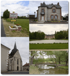 Clockwise from top left: Road sign, the town hall and post office, the chateau, footbridge, the church | |
Flag | |
Location of Vernou-en-Sologne 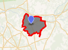
| |
 Vernou-en-Sologne  Vernou-en-Sologne | |
| Coordinates: 47°30′07″N 1°40′51″E | |
| Country | France |
| Region | Centre-Val de Loire |
| Department | Loir-et-Cher |
| Arrondissement | Romorantin-Lanthenay |
| Canton | Romorantin-Lanthenay |
| Intercommunality | Sologne des étangs |
| Government | |
| • Mayor (2014–2020) | Jack Terrier |
| Area 1 | 51.31 km2 (19.81 sq mi) |
| Population (2017-01-01)[1] | 624 |
| • Density | 12/km2 (31/sq mi) |
| Time zone | UTC+01:00 (CET) |
| • Summer (DST) | UTC+02:00 (CEST) |
| INSEE/Postal code | 41271 /41230 |
| Elevation | 82–116 m (269–381 ft) (avg. 95 m or 312 ft) |
| 1 French Land Register data, which excludes lakes, ponds, glaciers > 1 km2 (0.386 sq mi or 247 acres) and river estuaries. | |
Population
| Year | Pop. | ±% |
|---|---|---|
| 1793 | 862 | — |
| 1806 | 880 | +2.1% |
| 1821 | 832 | −5.5% |
| 1831 | 865 | +4.0% |
| 1841 | 776 | −10.3% |
| 1851 | 909 | +17.1% |
| 1861 | 873 | −4.0% |
| 1872 | 881 | +0.9% |
| 1881 | 947 | +7.5% |
| 1891 | 894 | −5.6% |
| 1901 | 927 | +3.7% |
| 1911 | 1,035 | +11.7% |
| 1921 | 924 | −10.7% |
| 1931 | 903 | −2.3% |
| 1946 | 813 | −10.0% |
| 1954 | 784 | −3.6% |
| 1962 | 705 | −10.1% |
| 1968 | 621 | −11.9% |
| 1975 | 528 | −15.0% |
| 1982 | 502 | −4.9% |
| 1990 | 543 | +8.2% |
| 1999 | 524 | −3.5% |
| 2006 | 572 | +9.2% |
| 2015 | 618 | +8.0% |
See also
| Wikimedia Commons has media related to Vernou-en-Sologne. |
| Authority control |
|
|---|
- "Populations légales 2017". INSEE. Retrieved 6 January 2020.
This article is issued from Wikipedia. The text is licensed under Creative Commons - Attribution - Sharealike. Additional terms may apply for the media files.