Selles-Saint-Denis
Selles-Saint-Denis is a commune in the Loir-et-Cher department of central France.
Selles-Saint-Denis | |
|---|---|
Commune | |
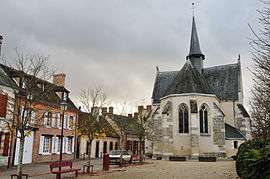 Chapel of Saint-Genouph | |
Location of Selles-Saint-Denis 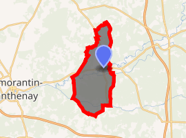
| |
 Selles-Saint-Denis  Selles-Saint-Denis | |
| Coordinates: 47°23′12″N 1°55′25″E | |
| Country | France |
| Region | Centre-Val de Loire |
| Department | Loir-et-Cher |
| Arrondissement | Romorantin-Lanthenay |
| Canton | La Sologne |
| Intercommunality | La Sologne des rivières |
| Government | |
| • Mayor (2014–2020) | Pierre Maurice |
| Area 1 | 50.98 km2 (19.68 sq mi) |
| Population (2017-01-01)[1] | 1,337 |
| • Density | 26/km2 (68/sq mi) |
| Time zone | UTC+01:00 (CET) |
| • Summer (DST) | UTC+02:00 (CEST) |
| INSEE/Postal code | 41241 /41300 |
| Elevation | 89–129 m (292–423 ft) |
| 1 French Land Register data, which excludes lakes, ponds, glaciers > 1 km2 (0.386 sq mi or 247 acres) and river estuaries. | |
Geography
The Rère River flows west through the southern part of the commune.
Population
| Year | Pop. | ±% |
|---|---|---|
| 1793 | 1,640 | — |
| 1806 | 1,656 | +1.0% |
| 1821 | 1,737 | +4.9% |
| 1831 | 1,868 | +7.5% |
| 1841 | 1,928 | +3.2% |
| 1851 | 1,954 | +1.3% |
| 1961 | 1,113 | −43.0% |
| 1872 | 1,211 | +8.8% |
| 1881 | 1,320 | +9.0% |
| 1891 | 1,214 | −8.0% |
| 1901 | 1,245 | +2.6% |
| 1911 | 1,224 | −1.7% |
| 1921 | 1,237 | +1.1% |
| 1931 | 1,087 | −12.1% |
| 1946 | 1,182 | +8.7% |
| 1954 | 1,062 | −10.2% |
| 1962 | 1,014 | −4.5% |
| 1968 | 1,024 | +1.0% |
| 1975 | 1,071 | +4.6% |
| 1982 | 1,172 | +9.4% |
| 1990 | 1,199 | +2.3% |
| 1999 | 1,193 | −0.5% |
| 2006 | 1,205 | +1.0% |
| 2015 | 1,316 | +9.2% |
See also
| Wikimedia Commons has media related to Selles-Saint-Denis. |
| Authority control |
|
|---|
- "Populations légales 2017". INSEE. Retrieved 6 January 2020.
This article is issued from Wikipedia. The text is licensed under Creative Commons - Attribution - Sharealike. Additional terms may apply for the media files.