Ur, Pyrénées-Orientales
Ur (French pronunciation: [yːʁ]), Occitan: [yɾ] is a commune in the Pyrénées-Orientales department in southern France.
Ur | |
|---|---|
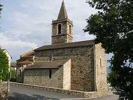 The church of Saint-Martin, in Ur | |
 Coat of arms | |
Location of Ur 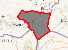
| |
 Ur  Ur | |
| Coordinates: 42°27′46″N 1°56′18″E | |
| Country | France |
| Region | Occitanie |
| Department | Pyrénées-Orientales |
| Arrondissement | Prades |
| Canton | Les Pyrénées catalanes |
| Intercommunality | Pyrénées Cerdagne |
| Government | |
| • Mayor (2001–2008) | Christian Ginestet |
| Area 1 | 6.79 km2 (2.62 sq mi) |
| Population (2017-01-01)[1] | 363 |
| • Density | 53/km2 (140/sq mi) |
| Time zone | UTC+01:00 (CET) |
| • Summer (DST) | UTC+02:00 (CEST) |
| INSEE/Postal code | 66218 /66760 |
| Elevation | 1,155–1,540 m (3,789–5,052 ft) (avg. 1,250 m or 4,100 ft) |
| 1 French Land Register data, which excludes lakes, ponds, glaciers > 1 km2 (0.386 sq mi or 247 acres) and river estuaries. | |
Toponymy
The name of the village is attested in the form Hur as early as 839 AD, and is of pre-Indo-European origin, coming from the Ur-Or-Ar root - quite common in the Pyrenees - which designates a place where there is a spring or a river; the pre-Celtic root *Ur- still means "water" in Basque. Despite local folklore, there is no known relation to the Biblical city-state of Ur.
Geography
Ur is located in the canton of Les Pyrénées catalanes and in the arrondissement of Prades.
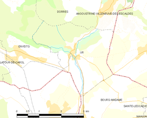
Map of Ur and its surrounding communes
Population
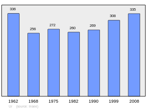
Population 1962-2008
References
- "Populations légales 2017". INSEE. Retrieved 6 January 2020.
| Wikimedia Commons has media related to Ur (Pyrénées-Orientales). |
| Authority control |
|
|---|
This article is issued from Wikipedia. The text is licensed under Creative Commons - Attribution - Sharealike. Additional terms may apply for the media files.