Sauto, Pyrénées-Orientales
Sauto (Catalan: Sautó i Fetges) is a commune in the Pyrénées-Orientales department in southern France. It is reached by the TER Occitanie, which serves the station of Gare de Sauto.
Sauto Sautó i Fetges | |
|---|---|
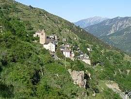 A general view of Sauto | |
Location of Sauto 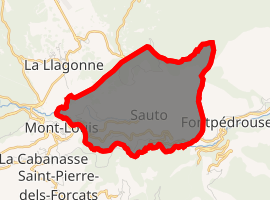
| |
 Sauto  Sauto | |
| Coordinates: 42°30′48″N 2°09′07″E | |
| Country | France |
| Region | Occitanie |
| Department | Pyrénées-Orientales |
| Arrondissement | Prades |
| Canton | Les Pyrénées catalanes |
| Intercommunality | Capcir Haut-Conflent |
| Government | |
| • Mayor (2001–2008) | Michel Santanac |
| Area 1 | 8.43 km2 (3.25 sq mi) |
| Population (2017-01-01)[1] | 91 |
| • Density | 11/km2 (28/sq mi) |
| Time zone | UTC+01:00 (CET) |
| • Summer (DST) | UTC+02:00 (CEST) |
| INSEE/Postal code | 66192 /66210 |
| Elevation | 1,100–2,030 m (3,610–6,660 ft) (avg. 1,600 m or 5,200 ft) |
| 1 French Land Register data, which excludes lakes, ponds, glaciers > 1 km2 (0.386 sq mi or 247 acres) and river estuaries. | |
Geography
Sauto is located in the canton of Les Pyrénées catalanes and in the arrondissement of Prades.
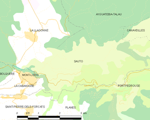
Map of Sauto and its surrounding communes
Population
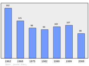
Population 1962-2008
References
- "Populations légales 2017". INSEE. Retrieved 6 January 2020.
| Wikimedia Commons has media related to Sauto. |
| Authority control |
|
|---|
This article is issued from Wikipedia. The text is licensed under Creative Commons - Attribution - Sharealike. Additional terms may apply for the media files.