Sus-Saint-Léger
Sus-Saint-Léger is a commune in the Pas-de-Calais department in the Hauts-de-France region of France.
Sus-Saint-Léger | |
|---|---|
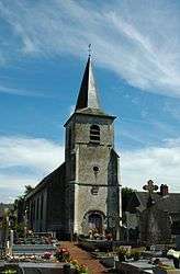 The church of Sus-Saint-Léger | |
 Coat of arms | |
Location of Sus-Saint-Léger 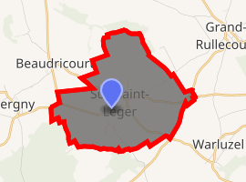
| |
 Sus-Saint-Léger  Sus-Saint-Léger | |
| Coordinates: 50°14′15″N 2°25′51″E | |
| Country | France |
| Region | Hauts-de-France |
| Department | Pas-de-Calais |
| Arrondissement | Arras |
| Canton | Avesnes-le-Comte |
| Intercommunality | CC Campagnes de l'Artois |
| Government | |
| • Mayor (2008–2014) | Marc Dufour |
| Area 1 | 7.31 km2 (2.82 sq mi) |
| Population (2017-01-01)[1] | 376 |
| • Density | 51/km2 (130/sq mi) |
| Time zone | UTC+01:00 (CET) |
| • Summer (DST) | UTC+02:00 (CEST) |
| INSEE/Postal code | 62804 /62810 |
| Elevation | 118–167 m (387–548 ft) (avg. 149 m or 489 ft) |
| 1 French Land Register data, which excludes lakes, ponds, glaciers > 1 km2 (0.386 sq mi or 247 acres) and river estuaries. | |
Geography
Sus-Saint-Léger lies 20 miles (32.2 km) southwest of Arras, at the junction of the D23 and D59 roads and on the border with the department of the Somme.
Population
| 1962 | 1968 | 1975 | 1982 | 1990 | 1999 | 2006 |
|---|---|---|---|---|---|---|
| 422 | 425 | 363 | 340 | 331 | 292 | 340 |
| Census count starting in 1962: Population without duplicates | ||||||
Places of interest
- The church of St.Leger, dating from the sixteenth century.
- The eighteenth-century chateau.
- A seventeenth-century manor house.
- Traces of a feudal motte
External links
| Wikimedia Commons has media related to Sus-Saint-Léger. |
- Sus-Saint-Léger on the Quid website (in French)
| Authority control |
|
|---|
This article is issued from Wikipedia. The text is licensed under Creative Commons - Attribution - Sharealike. Additional terms may apply for the media files.