Saint-Michel-sur-Ternoise
Saint-Michel-sur-Ternoise is a commune in the Pas-de-Calais department in the Hauts-de-France region of France.
Saint-Michel-sur-Ternoise | |
|---|---|
.jpg) An aerial view of Saint-Michel-sur-Ternoise | |
 Coat of arms | |
Location of Saint-Michel-sur-Ternoise 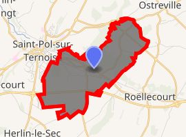
| |
 Saint-Michel-sur-Ternoise  Saint-Michel-sur-Ternoise | |
| Coordinates: 50°22′34″N 2°21′44″E | |
| Country | France |
| Region | Hauts-de-France |
| Department | Pas-de-Calais |
| Arrondissement | Arras |
| Canton | Saint-Pol-sur-Ternoise |
| Intercommunality | CC Ternois |
| Government | |
| • Mayor (2008–2014) | Josette Édouart |
| Area 1 | 5.97 km2 (2.31 sq mi) |
| Population (2017-01-01)[1] | 878 |
| • Density | 150/km2 (380/sq mi) |
| Time zone | UTC+01:00 (CET) |
| • Summer (DST) | UTC+02:00 (CEST) |
| INSEE/Postal code | 62763 /62130 |
| Elevation | 87–147 m (285–482 ft) (avg. 90 m or 300 ft) |
| 1 French Land Register data, which excludes lakes, ponds, glaciers > 1 km2 (0.386 sq mi or 247 acres) and river estuaries. | |
Geography
Saint-Michel-sur-Ternoise is an eastern suburb of St.Pol, on the banks of the Ternoise river, some 24 miles (39 km) west of Arras, at the junction of the D8 and D85 roads.
Population
| 1962 | 1968 | 1975 | 1982 | 1990 | 1999 | 2006 |
|---|---|---|---|---|---|---|
| 652 | 783 | 935 | 933 | 926 | 943 | 959 |
| Census count starting from 1962: Population without duplicates | ||||||
Places of interest
- The church of St.Michel, dating from the sixteenth century.
References
- "Populations légales 2017". INSEE. Retrieved 6 January 2020.
| Wikimedia Commons has media related to Saint-Michel-sur-Ternoise. |
| Authority control |
|
|---|
This article is issued from Wikipedia. The text is licensed under Creative Commons - Attribution - Sharealike. Additional terms may apply for the media files.