Rollancourt
Rollancourt is a commune in the Pas-de-Calais department in the Hauts-de-France region of France.
Rollancourt | |
|---|---|
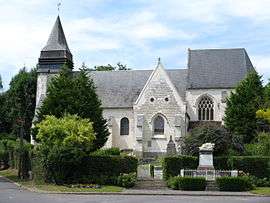 The church of Rollancourt | |
 Coat of arms | |
Location of Rollancourt 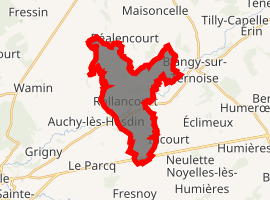
| |
 Rollancourt  Rollancourt | |
| Coordinates: 50°24′31″N 2°07′24″E | |
| Country | France |
| Region | Hauts-de-France |
| Department | Pas-de-Calais |
| Arrondissement | Montreuil |
| Canton | Auxi-le-Château |
| Intercommunality | CC Sept Vallées |
| Government | |
| • Mayor (2001–2008) | Alexandre Podvin |
| Area 1 | 11.59 km2 (4.47 sq mi) |
| Population (2017-01-01)[1] | 307 |
| • Density | 26/km2 (69/sq mi) |
| Time zone | UTC+01:00 (CET) |
| • Summer (DST) | UTC+02:00 (CEST) |
| INSEE/Postal code | 62719 /62770 |
| Elevation | 30–116 m (98–381 ft) (avg. 35 m or 115 ft) |
| 1 French Land Register data, which excludes lakes, ponds, glaciers > 1 km2 (0.386 sq mi or 247 acres) and river estuaries. | |
Geography
Rollancourt is located 18 miles (28 km) southeast of Montreuil-sur-Mer on the D107 road, in the valley of the Ternoise river.
Population
| 1962 | 1968 | 1975 | 1982 | 1990 | 1999 | 2006 |
|---|---|---|---|---|---|---|
| 277 | 304 | 311 | 321 | 276 | 301 | 456 |
| Census count starting from 1962: Population without duplicates | ||||||
Places of interest
- The church of St.Riquier, dating from the fifteenth century.
- The Manoir de Courcelles, XIIth, XVIth and XVIIIth centuries
- A Louis XV château.
- Traces of an ancient château.
External links
| Wikimedia Commons has media related to Rollancourt. |
- Rollancourt on the Insee website (in French)
- Rollancourt on the Quid website (in French)
| Authority control |
|
|---|
This article is issued from Wikipedia. The text is licensed under Creative Commons - Attribution - Sharealike. Additional terms may apply for the media files.