Sonora, California
Sonora is the county seat of Tuolumne County, California. The city population was 4,610 during the 2010 Census, an increase of 380 from the 4,230 counted during the 2000 Census. Sonora is the only incorporated community in Tuolumne County.
City of Sonora | |
|---|---|
City | |
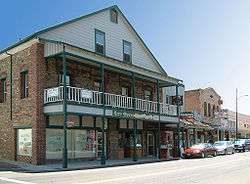 The old city hotel on South Washington Street | |
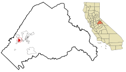 Location in Tuolumne County and the state of California | |
 City of Sonora Location in the United States | |
| Coordinates: 37°59′4″N 120°22′54″W | |
| Country | United States |
| State | California |
| County | Tuolumne |
| Incorporated | February 15, 1850[1] |
| Government | |
| • Mayor | Matt Hawkins |
| • City Administrator | Mary Rose Rutikanga |
| Area | |
| • Total | 3.18 sq mi (8.23 km2) |
| • Land | 3.16 sq mi (8.19 km2) |
| • Water | 0.01 sq mi (0.04 km2) 0.45% |
| Elevation | 1,796 ft (898 m) |
| Population (2010) | |
| • Total | 4,610 |
| • Estimate (2019)[4] | 4,864 |
| • Density | 1,537.78/sq mi (593.79/km2) |
| Time zone | UTC−8 (Pacific) |
| • Summer (DST) | UTC−7 (PDT) |
| ZIP Codes | 95370, 95373 |
| Area code | 209 |
| FIPS code | 06-72674 |
| GNIS feature IDs | 1659815, 2411930 |
| Website | www |
History
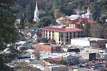
Founded by Mexican miners — many experienced ones from the state of Sonora, Mexico — during the California Gold Rush. Sonora was once a booming center of industry and trade in California's Mother Lode. Most of the gold that was removable with traditional mining techniques was quickly extracted, leaving miners to use more complex and expensive mining techniques to reach deep pockets of quartz and gold. Sonora as well as other mining towns of the era experienced economic hardship when the value of gold decreased. As easier accessible gold deposits dried up, businesses and miners realized extracting the gold cost more than it was worth. As "gold fever" died down, Sonora's size and population steadily decreased over the years.[5]
A local museum serves to remind locals and visitors of the Gold Rush era and what Sonora was once like.
As detailed by novelist David Carkeet, in his memoir, Campus Sexpot, Sonora was fictionalized as "Wattsville", the setting of Dale Koby's cult/underground classic (also titled Campus Sexpot).[6] The sequel, From Roundheel To Revolutionary by Jeff Daiell, also takes place primarily in "Wattsville"/Sonora.
Geography
Sonora is located at 37°59′04″N 120°22′54″W,[7] around the intersection of California State Highways 49 and 108 The altitude is 1,825 feet (556 m). According to the United States Census Bureau, the city has a total area of 3.1 square miles (8.0 km2), 99.55% of it land and 0.45% of it water.
Climate
Sonora has cool, wet winters and hot, mostly dry summers. Average January temperatures are a maximum of 54.5 °F (12.5 °C) and a minimum of 33.5 °F (0.8 °C). Average July temperatures are a maximum of 101.6 °F (38.7 °C) and a minimum of 58.8 °F (14.9 °C). There are an average of 95.5 days annually with highs of 90 °F (32 °C) or higher and an average of 52.2 days annually with lows of 32 °F (0 °C) or lower. The record high temperature was 113 °F (45 °C) on June 22, 1961, and July 15, 1972. The record low temperature was 8 °F (−13 °C) on December 9, 1972.
Average annual rainfall is 32.07 inches (815 mm), almost all from November through April, although there are occasionally afternoon and evening thunderstorms in the summer months, which drift down from the Sierra Nevada. There are an average of 60 days annually with measurable precipitation. The wettest “rain year” has been from July 1994 to June 1995 with 56.40 inches (1,432.6 mm) and the driest from July 1975 to June 1976 with 15.26 inches (387.6 mm).[8] The most rainfall in one month was 21.69 inches (551 mm) in December 1955, including 7.10 inches (180.3 mm) on December 27, the record 24-hour rainfall. Average annual snowfall is only 4.7 inches (0.12 m). The most snowfall in one month was 30.5 inches (0.77 m) in January 1933.[9] The Köppen Climate Classification subtype for this climate is Csa (Mediterranean climate).[10]
| Climate data for Sonora, California | |||||||||||||
|---|---|---|---|---|---|---|---|---|---|---|---|---|---|
| Month | Jan | Feb | Mar | Apr | May | Jun | Jul | Aug | Sep | Oct | Nov | Dec | Year |
| Record high °F (°C) | 75 (24) |
78 (26) |
84 (29) |
92 (33) |
103 (39) |
113 (45) |
113 (45) |
110 (43) |
108 (42) |
100 (38) |
89 (32) |
81 (27) |
113 (45) |
| Average high °F (°C) | 54.5 (12.5) |
58.0 (14.4) |
62.4 (16.9) |
68.5 (20.3) |
77.1 (25.1) |
86.1 (30.1) |
94.5 (34.7) |
93.0 (33.9) |
86.7 (30.4) |
76.0 (24.4) |
63.5 (17.5) |
55.6 (13.1) |
73.0 (22.8) |
| Daily mean °F (°C) | 43.9 (6.6) |
46.7 (8.2) |
50.2 (10.1) |
55.1 (12.8) |
61.9 (16.6) |
69.4 (20.8) |
76.6 (24.8) |
75.2 (24.0) |
69.7 (20.9) |
60.6 (15.9) |
50.8 (10.4) |
44.7 (7.1) |
58.7 (14.8) |
| Average low °F (°C) | 33.4 (0.8) |
35.5 (1.9) |
38.0 (3.3) |
41.7 (5.4) |
46.7 (8.2) |
52.7 (11.5) |
58.7 (14.8) |
57.4 (14.1) |
52.7 (11.5) |
45.2 (7.3) |
38.1 (3.4) |
33.8 (1.0) |
44.5 (6.9) |
| Record low °F (°C) | 13 (−11) |
15 (−9) |
20 (−7) |
24 (−4) |
24 (−4) |
33 (1) |
39 (4) |
40 (4) |
33 (1) |
25 (−4) |
21 (−6) |
8 (−13) |
8 (−13) |
| Average precipitation inches (mm) | 6.13 (156) |
5.55 (141) |
5.10 (130) |
2.77 (70) |
1.27 (32) |
0.33 (8.4) |
0.04 (1.0) |
0.08 (2.0) |
0.39 (9.9) |
1.62 (41) |
3.46 (88) |
5.39 (137) |
32.14 (816) |
| Average snowfall inches (cm) | 2.3 (5.8) |
1.0 (2.5) |
0.5 (1.3) |
0.2 (0.51) |
0 (0) |
0 (0) |
0 (0) |
0 (0) |
0 (0) |
0 (0) |
0 (0) |
0.7 (1.8) |
4.7 (12) |
| Average precipitation days | 10 | 9 | 9 | 6 | 4 | 2 | 0 | 0 | 1 | 4 | 6 | 9 | 61 |
| Source: Western Regional Climate Center[11] | |||||||||||||
Demographics
| Historical population | |||
|---|---|---|---|
| Census | Pop. | %± | |
| 1860 | 1,960 | — | |
| 1870 | 1,322 | −32.6% | |
| 1880 | 1,492 | 12.9% | |
| 1890 | 1,441 | −3.4% | |
| 1900 | 1,922 | 33.4% | |
| 1910 | 2,029 | 5.6% | |
| 1920 | 1,684 | −17.0% | |
| 1930 | 2,278 | 35.3% | |
| 1940 | 2,257 | −0.9% | |
| 1950 | 2,448 | 8.5% | |
| 1960 | 2,725 | 11.3% | |
| 1970 | 3,100 | 13.8% | |
| 1980 | 3,247 | 4.7% | |
| 1990 | 4,153 | 27.9% | |
| 2000 | 4,423 | 6.5% | |
| 2010 | 4,610 | 4.2% | |
| Est. 2019 | 4,864 | [4] | 5.5% |
| U.S. Decennial Census[12] | |||
2010
At the 2010 census Sonora had a population of 4,903. The population density was 1,593.0 people per square mile (615.0/km2). The racial makeup of Sonora was 4,402 (89.8%) White, 24 (0.5%) African American, 95 (1.9%) Native American, 79 (1.6%) Asian, 12 (0.2%) Pacific Islander, 84 (1.7%) from other races, and 207 (4.2%) from two or more races. Hispanic or Latino of any race were 542 people (11.1%).[13]
The census reported that 4,613 people (94.1% of the population) lived in households, 85 (1.7%) lived in non-institutionalized group quarters, and 205 (4.2%) were institutionalized.
There were 2,199 households, 562 (25.6%) had children under the age of 18 living in them, 689 (31.3%) were opposite-sex married couples living together, 308 (14.0%) had a female householder with no husband present, 116 (5.3%) had a male householder with no wife present. There were 192 (8.7%) unmarried opposite-sex partnerships, and 12 (0.5%) same-sex married couples or partnerships. 881 households (40.1%) were one person and 312 (14.2%) had someone living alone who was 65 or older. The average household size was 2.10. There were 1,113 families (50.6% of households); the average family size was 2.77.
The age distribution was 975 people (19.9%) under the age of 18, 526 people (10.7%) aged 18 to 24, 1,266 people (25.8%) aged 25 to 44, 1,324 people (27.0%) aged 45 to 64, and 812 people (16.6%) who were 65 or older. The median age was 39.7 years. For every 100 females, there were 93.0 males. For every 100 females age 18 and over, there were 89.9 males.
There were 2,463 housing units at an average density of 800.2 per square mile, of the occupied units 898 (40.8%) were owner-occupied and 1,301 (59.2%) were rented. The homeowner vacancy rate was 4.6%; the rental vacancy rate was 8.6%. 1,960 people (40.0% of the population) lived in owner-occupied housing units and 2,653 people (54.1%) lived in rental housing units.
2000
At the 2000 census,[14] there were 4,423 people in 2,051 households, including 1,046 families, in the city. The population density was 1,456.2 people per square mile (561.8/km2). There were 2,197 housing units at an average density of 723.3 per square mile (279.0/km2). The racial makeup of the city was 91.4% White, 0.7% African American, 1.5% Native American, 1.2% Asian, 0.1% Pacific Islander, 2.0% from other races, and 3.1% from two or more races. Hispanic or Latino of any race comprise 8.4% of the population.
There were 2,051 households, 24.0% had children under the age of 18, 33.2% were married couples living together, 14.0% had a female householder with no husband present, and 49.0% were non-families. 40.3% of households were made up of individuals and 15% had someone living alone who was 65 or older. The average household size was 2.06 and the average family size was 2.75.
The age distribution was 20.4% under the age of 18, 9.5% from 18 to 24, 26.3% from 25 to 44, 23.5% from 45 to 64, and 20.4% who were 65 or older. The median age was 41 years. For every 100 females, there were 82.8 males. For every 100 females age 18 and over, there were 77.1 males.
The median household income was $28,858 and the median family income was $39,722. Males had a median income of $40,958 versus $26,111 for females. The per capita income for the city was $19,248. 16.9% of the population and 10.9% of families were below the poverty line. Out of the total population, 22.8% of those under the age of 18 and 7.2% of those 65 and older were living below the poverty line.
Economy and tourism
The area economy was historically based on the mining and timber industries, but now relies on tourism.[15] One of two active lumber mills in Tuolumne County was shut down in 2009, but reopened in July 2011.[16]
As the closest city to Yosemite National Park, Sonora provides services to some of Yosemite's visitors. The city also benefits from its proximity to Railtown 1897 State Historic Park.
Education
The city's schools include its namesake educational institutions Sonora Union High School[17] and Sonora Elementary School,[18] as well as Dario Cassina High[19] and the Foothill Horizons Outdoor School.
Columbia Community College is part of Yosemite Community College District (YCCD) which also includes Modesto Junior College is the sole college in Tuolumne County and offers two-year degrees. Individuals wishing to attend a university must commute 50 miles to University of California, Merced or California State University, Stanislaus in Turlock.
Government and politics
Sonora uses a city council consisting of five council members, including the mayor. The city council appoints a city administrator to implement the council's policies and enforce ordinances. As of March 2020, the current mayor of Sonora is Matt Hawkins and the current city administrator is Mary Rose Rutikanga.[20][21]
In the California State Legislature, Sonora is in the 8th Senate District, represented by Republican Andreas Borgeas, and in the 5th Assembly District, represented by Republican Frank Bigelow.[22]
In the United States House of Representatives, Sonora is in California's 4th congressional district, represented by Republican Tom McClintock.[23]
Culture and arts
The newspaper of record for the Sonora area is the Union Democrat.[24]
The Tuolumne County Film Commission describes Sonora as "one of the country's most versatile locations", where more than "300 film and television series" have been made.[25]
Local museums depict the Gold Rush era and historic Sonora.
The small town is home to two resident theatre companies. The community theatre Stage 3 [26] produces comedic and dramatic plays in its small space, often providing pre-show musical entertainment from local singers and groups. The professional theatre company Sierra Repertory Theatre[27] produces a variety of musicals and plays each year at two different theatre buildings, the East Sonora Theatre and the Fallon House Theatre in Columbia.
Sonora is also home to the Tuolumne County Arts Alliance.[28]
Notable people
- Vaughn Armstrong – actor
- Melvin Belli – attorney
- David Carkeet - writer
- Jack Cassinetto – painter
- Phil Coke – MLB pitcher
- Molly Culver - actress
- Charles Dellschau – artist
- T.J. Dillashaw - UFC Bantamweight Champion
- Ross Dwelley - NFL tight end
- Larry Franco - Film Producer (Hulk - Jumanji - more)
- James P. Hogan – writer
- Jenny O'Hara – actress
- Josh Parry - NFL fullback
- Dan Pastorini – NFL quarterback
- Francis "Rocco" Prestia - bassist of Tower of Power
- Tata Vega - Entertainer
- Kahale Warring - NFL Tight End
References
- "California Cities by Incorporation Date". California Association of Local Agency Formation Commissions. Archived from the original (Word) on February 21, 2013. Retrieved August 25, 2014.
- "2019 U.S. Gazetteer Files". United States Census Bureau. Retrieved July 1, 2020.
- "Sonora". Geographic Names Information System. United States Geological Survey. Retrieved November 5, 2014.
- "Population and Housing Unit Estimates". United States Census Bureau. May 24, 2020. Retrieved May 27, 2020.
- "A Short History - City of Sonora". City of Sonora. Retrieved October 30, 2017.
- Carkeet, David (2005). Campus Sexpot: A Memoir. University of Georgia Press. ISBN 9780820330761.
- "US Gazetteer files: 2010, 2000, and 1990". United States Census Bureau. February 12, 2011. Retrieved April 23, 2011.
- National Weather Service (Sacramento); NOW Data
- "SONORA, CALIFORNIA - Climate Summary". dri.edu. Retrieved August 4, 2015.
- "Sonora, California Köppen Climate Classification (Weatherbase)". Weatherbase. Retrieved August 4, 2015.
- "Sonora, California". Western Regional Climate Center. Desert Research Institute. Retrieved May 20, 2020.
- "Census of Population and Housing". Census.gov. Retrieved June 4, 2015.
- "2010 Census Interactive Population Search: CA - Sonora city". U.S. Census Bureau. Archived from the original on July 15, 2014. Retrieved July 12, 2014.
- "U.S. Census website". United States Census Bureau. Retrieved January 31, 2008.
- "Membership benefits". Tuolumne County Chamber of Commerce. 2011. Archived from the original on June 5, 2011. Retrieved July 13, 2011.
- Nichols, Dana M (July 10, 2011). "Retooled lumber mill back in business". Dow Jones Local Media Group, Inc. Retrieved July 13, 2011.
- "Sonora Union High - School Directory Details (CA Dept of Education)". www.cde.ca.gov. Retrieved February 18, 2019.
- "Sonora Elementary - School Directory Details (CA Dept of Education)". www.cde.ca.gov. Retrieved February 18, 2019.
- "Dario Cassina High - School Directory Details (CA Dept of Education)". www.cde.ca.gov. Retrieved February 18, 2019.
- "Sonora's City Council - City of Sonora". City of Sonora. Retrieved March 31, 2020.
- "City Administrator - City of Sonora". City of Sonora. Retrieved March 31, 2020.
- "Statewide Database". UC Regents. Archived from the original on February 1, 2015. Retrieved November 29, 2014.
- "California's 4th Congressional District - Representatives & District Map". Civic Impulse, LLC. Retrieved September 28, 2014.
- AbDivine, The Union Democrat. "About Us". uniondemocrat.com. Retrieved August 4, 2015.
- "Home page". Tuolumne County Film Commission. Archived from the original on October 12, 2010. Retrieved May 7, 2010.
- "STAGE 3 THEATRE COMPANY". Retrieved August 4, 2015.
- "Sierra Repertory Theatre". sierrarep.org. Retrieved August 4, 2015.
- "Imagine". Retrieved August 4, 2015.
External links
| Wikimedia Commons has media related to Sonora, California. |
Municipalities and communities of Tuolumne County, California, United States | ||
|---|---|---|
| City | 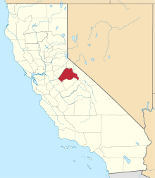 Tuolumne County map | |
| CDPs | ||
| Unincorporated communities | ||
| Ghost towns |
| |
| Authority control |
|
|---|