Madera, California
Madera (Spanish for wood), is a city in California and the county seat of Madera County.[10] As of the 2010 United States Census, the city's population was 61,416, up from 43,207 in 2000.
Madera, California | |
|---|---|
City | |
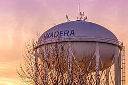 Photograph of City of Madera Water Tower taken during a Fall sunset. | |
| Nickname(s): "The Heart of California"[1] | |
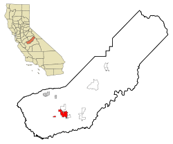 Location in Madera County and the state of California | |
 Madera, California Location in California | |
| Coordinates: 36°57′41″N 120°03′39″W | |
| Country | |
| State | |
| County | |
| Regions | Central Valley Northern California |
| Incorporated | March 27, 1907[2] |
| Government | |
| • Type | Council and Manager[3] |
| • City council[4] |
|
| • City administrator | Arnoldo Rodriguez [5] |
| Area | |
| • City | 16.48 sq mi (42.67 km2) |
| • Land | 16.48 sq mi (42.67 km2) |
| • Water | 0.00 sq mi (0.00 km2) 0% |
| Elevation | 272 ft (83 m) |
| Population | |
| • City | 61,416 |
| • Estimate (2019)[9] | 65,860 |
| • Density | 3,997.57/sq mi (1,543.51/km2) |
| • Metro | 152,465 |
| Demonym(s) | Maderan |
| Time zone | UTC−8 (Pacific) |
| • Summer (DST) | UTC−7 (PDT) |
| ZIP codes | 93636–93639 |
| Area code | 559 |
| FIPS code | 06-45022 |
| GNIS feature IDs | 277552, 2410906 |
| Website | www |
Located in the San Joaquin Valley, Madera is the principal city of the Madera Metropolitan Statistical Area, which is part of the Fresno-Madera-Hanford Combined Statistical Area. The city is also home to the Madera Unified School District.
History
The town was named after the Spanish term for lumber.[11] The town was laid out by the California Lumber Company in 1876.[11] From 1876 to 1931, a 63-mile water flume carried lumber from the mountains to Madera where the lumber was shipped by train.
The first post office at Madera opened in 1877[11] and the town incorporated on March 27, 1907.[11] One of the city's first African Americans to hold an elected office was Rev. Naaman N. Haynes, who was voted in as school board trustee in the 1960s.[12]
Landmarks include the historic Madera County Courthouse, the notable Madera water tower, and a fully operational drive-in movie theater.[13]
Geography
Madera is located at 36°57′41″N 120°03′39″W.[7] The geographic center of California is 38 mi (61 km) east of Madera. According to the United States Census Bureau, the city has a total area of 15.8 square miles (41 km2), all land.
Madera is the location of the Madera AVA wine region.
Climate
Madera has a steppe climate (Köppen: BSk),[14] in the central zone of this climatic subtype.[15] Average January temperatures are a maximum of 54.2 °F (12.3 °C) and a minimum of 36.8 °F (2.7 °C). Average July temperatures are a maximum of 96.6 °F (35.9 °C) and a minimum of 62.3 °F (16.8 °C). Annually, there are an average of 103.9 afternoons with highs of 90 °F (32 °C) or higher, 26.1 afternoons reaching or exceeding 100 °F (38 °C), and an average of 24.6 mornings with lows of 32 °F (0 °C) or lower. The record high temperature was 116 °F (47 °C), recorded on July 13, 1961. The record low temperature was 15 °F (−9 °C), recorded on January 10, 1949.
The average annual rainfall is 11.87 inches (301.5 mm) and there are an average of 59.3 days with measurable precipitation. The wettest year was 1983 with 22.13 inches (562.1 mm) and the driest was 2013 with 4.49 inches (114.0 mm).[16] The most rainfall in one month was 7.11 inches (180.6 mm), on March 1991. The most rainfall in 24 hours was 1.98 inches (50.3 mm), on November 21, 1978. Although snow is rare, 4.0 inches or 0.10 metres fell in January 1962.[17]
| Climate data for Madera, CA (normals 1981–2010, extremes 1928–present) | |||||||||||||
|---|---|---|---|---|---|---|---|---|---|---|---|---|---|
| Month | Jan | Feb | Mar | Apr | May | Jun | Jul | Aug | Sep | Oct | Nov | Dec | Year |
| Record high °F (°C) | 77 (25) |
83 (28) |
91 (33) |
99 (37) |
107 (42) |
115 (46) |
116 (47) |
113 (45) |
115 (46) |
101 (38) |
92 (33) |
76 (24) |
116 (47) |
| Mean maximum °F (°C) | 67.0 (19.4) |
71.9 (22.2) |
79.7 (26.5) |
89.9 (32.2) |
98.4 (36.9) |
103.1 (39.5) |
105.8 (41.0) |
104.6 (40.3) |
101.4 (38.6) |
92.7 (33.7) |
77.7 (25.4) |
66.2 (19.0) |
107.0 (41.7) |
| Average high °F (°C) | 54.2 (12.3) |
61.2 (16.2) |
67.2 (19.6) |
74.3 (23.5) |
83.4 (28.6) |
91.0 (32.8) |
96.6 (35.9) |
95.5 (35.3) |
90.2 (32.3) |
79.1 (26.2) |
64.9 (18.3) |
54.5 (12.5) |
76.1 (24.5) |
| Daily mean °F (°C) | 45.5 (7.5) |
50.3 (10.2) |
54.9 (12.7) |
60.0 (15.6) |
67.8 (19.9) |
74.3 (23.5) |
79.4 (26.3) |
78.1 (25.6) |
73.5 (23.1) |
63.9 (17.7) |
53.0 (11.7) |
45.5 (7.5) |
62.5 (16.9) |
| Average low °F (°C) | 36.8 (2.7) |
39.4 (4.1) |
42.8 (6.0) |
46.0 (7.8) |
52.2 (11.2) |
57.7 (14.3) |
62.3 (16.8) |
60.7 (15.9) |
56.7 (13.7) |
48.6 (9.2) |
40.6 (4.8) |
36.5 (2.5) |
48.7 (9.3) |
| Mean minimum °F (°C) | 27.8 (−2.3) |
29.8 (−1.2) |
33.4 (0.8) |
37.1 (2.8) |
42.7 (5.9) |
48.9 (9.4) |
54.3 (12.4) |
53.5 (11.9) |
48.4 (9.1) |
38.9 (3.8) |
30.0 (−1.1) |
26.7 (−2.9) |
25.3 (−3.7) |
| Record low °F (°C) | 15 (−9) |
21 (−6) |
24 (−4) |
29 (−2) |
33 (1) |
38 (3) |
42 (6) |
41 (5) |
34 (1) |
24 (−4) |
22 (−6) |
16 (−9) |
15 (−9) |
| Average precipitation inches (mm) | 2.21 (56) |
1.97 (50) |
2.08 (53) |
1.07 (27) |
0.54 (14) |
0.14 (3.6) |
0.01 (0.25) |
0.01 (0.25) |
0.12 (3.0) |
0.72 (18) |
1.19 (30) |
1.91 (49) |
11.87 (301) |
| Average precipitation days (≥ 0.01 in.) | 10.1 | 9.9 | 8.5 | 4.4 | 2.2 | 0.7 | 0.1 | 0.2 | 0.9 | 2.5 | 7.1 | 9.0 | 59.3 |
| Source: NOAA[18] | |||||||||||||
Demographics
| Historical population | |||
|---|---|---|---|
| Census | Pop. | %± | |
| 1880 | 217 | — | |
| 1890 | 950 | 337.8% | |
| 1910 | 2,404 | — | |
| 1920 | 3,444 | 43.3% | |
| 1930 | 4,665 | 35.5% | |
| 1940 | 6,457 | 38.4% | |
| 1950 | 10,497 | 62.6% | |
| 1960 | 14,430 | 37.5% | |
| 1970 | 16,044 | 11.2% | |
| 1980 | 21,732 | 35.5% | |
| 1990 | 29,281 | 34.7% | |
| 2000 | 43,207 | 47.6% | |
| 2010 | 61,416 | 42.1% | |
| Est. 2019 | 65,860 | [9] | 7.2% |
| U.S. Decennial Census[19] | |||
2010
The 2010 United States Census[20] reported that Madera had a population of 61,416. The population density was 3,889.7 people per square mile (1,501.8/km2). The racial makeup of Madera was 30,640 (49.9%) White, 2,069 (3.4%) African American, 1,933 (3.1%) Native American, 1,369 (2.2%) Asian, 72 (0.1%) Pacific Islander, 22,603 (36.8%) from other races, and 2,730 (4.4%) from two or more races. Hispanic or Latino of any race accounted for 47,103 people (76.7% of the population).
The Census reported that 60,825 people (99.0% of the population) lived in households, 418 (0.7%) lived in non-institutionalized group quarters, and 173 (0.3%) were institutionalized.
There were 15,938 households, out of which 9,003 (56.5%) had children under the age of 18 living in them, 8,521 (53.5%) were opposite-sex married couples living together, 2,917 (18.3%) had a female householder with no husband present, 1,450 (9.1%) had a male householder with no wife present. There were 1,323 (8.3%) unmarried opposite-sex partnerships, and 97 (0.6%) same-sex married couples or partnerships. 2,374 households (14.9%) were made up of individuals, and 1,077 (6.8%) had someone living alone who was 65 years of age or older. The average household size was 3.82. There were 12,888 families (80.9% of all households); the average family size was 4.09.
The population was spread out, with 21,338 people (34.7%) under the age of 18, 7,732 people (12.6%) aged 18 to 24, 17,287 people (28.1%) aged 25 to 44, 10,407 people (16.9%) aged 45 to 64, and 4,652 people (7.6%) who were 65 years of age or older. The median age was 26.6 years. For every 100 females, there were 104.0 males. For every 100 females age 18 and over, there were 103.3 males.
There were 17,049 housing units at an average density of 1,079.8 per square mile (416.9/km2), of which 8,096 (50.8%) were owner-occupied, and 7,842 (49.2%) were occupied by renters. The homeowner vacancy rate was 3.5%; the rental vacancy rate was 5.1%. 28,785 people (46.9% of the population) lived in owner-occupied housing units and 32,040 people (52.2%) lived in rental housing units.
2000
As of the census[21] of 2000, there were 43,207 people, 11,978 households, and 9,438 families residing in the city. The population density was 3,515.3 people per square mile (1,357.4/km2). There were 12,521 housing units at an average density of 1,018.7 per square mile (393.4/km2). The racial makeup of the city was 48.2% White, 3.9% African American, 2.8% Native American, 1.4% Asian, 0.1% Pacific Islander, 38.0% from other races, and 5.7% from two or more races. Hispanic or Latino of any race were 67.8% of the population.
There were 11,978 households, out of which 48.4% had children under the age of 18 living with them, 53.7% were married couples living together, 17.5% had a female householder with no husband present, and 21.2% were non-families. 16.8% of all households were made up of individuals, and 7.9% had someone living alone who was 65 years of age or older. The average household size was 3.57 and the average family size was 3.90.
In the city, the population was spread out, with 35.4% under the age of 18, 12.5% from 18 to 24, 28.3% from 25 to 44, 14.9% from 45 to 64, and 8.8% who were 65 years of age or older. The median age was 26 years. For every 100 females, there were 102.8 males. For every 100 females age 18 and over, there were 101.1 males.
The median income for a household in the city was $31,033, and the median income for a family was $31,927. Males had a median income of $29,776 versus $23,210 for females. The per capita income for the city was $11,674. About 25.6% of families and 32.5% of the population were below the poverty line, including 40.0% of those under age 18 and 12.7% of those age 65 or over.
Government
In the California State Legislature, Madera is in the 12th Senate District, represented by Democrat Anna Caballero, and in the 5th Assembly District, represented by Republican Frank Bigelow.[22]
In the United States House of Representatives, Madera is in California's 16th congressional district, represented by Democrat Jim Costa.[23]
Education
School districts
Higher educational sites
- Madera Community College Center (a campus of the State Center Community College District)
- San Joaquin Valley College Madera
Transportation
Within the city of Madera, State Route 99 carries traffic in a generally northwest / southeast orientation. East of the city, State Route 41 can be accessed via either eastbound county roads, or via State Route 145, the latter of which turns from a northeast / southwest bearing to a directly south orientation within the city. The eastern terminus of State Route 152 is located 10 miles (16 km) to the north of the city, on State Route 99.
Near Madera is the Madera Amtrak station. A California High-Speed Rail stop is also planned.[24]
The City of Madera provides local buses known as Madera Area Express (MAX).[25] Madera County provides bus connections with other communities in the county.[26]
Notable people
Noteworthy persons born or raised in Madera include:
- Frank Bergon, the author of four novels, including Jesse's Ghost (2011), which is set in Madera.
- Lee Evans, Olympic gold medalist and former world record holder in track and field.
- Zoila Frausto Gurgel, women's Mixed Martial Arts champion[27]
- Lavar Johnson, American mixed martial artist who competed[28] as a heavyweight for the Ultimate Fighting Championship (UFC).
- Jack W. Kelso (1934–1952), Medal of Honor recipient.
- Oswaldo Lopez, winner of the 2011 Badwater Ultramarathon.[29]
- Frank McNally, all-pro football player.[30]
- Kathryn Grove Shipp (1904-1977), explosives expert, raised in Madera
- Avery Stafford, gospel and R&B vocalist
- Brian Turner, an American poet known for writing about his experience as a soldier in the Iraq War.
See also
References
- "City of Madera : The Heart of California". City of Madera. Retrieved July 11, 2020.
- "California Cities by Incorporation Date". California Association of Local Agency Formation Commissions. Archived from the original (Word) on February 21, 2013. Retrieved August 25, 2014.
- "Government". City of Madera. Retrieved February 13, 2015.
- "Mayor & City Council". City of Madera. Retrieved January 31, 2017.
- "City Administrator". City of Madera. Retrieved January 19, 2015.
- "2019 U.S. Gazetteer Files". United States Census Bureau. Retrieved July 1, 2020.
- "Madera". Geographic Names Information System. United States Geological Survey. Retrieved April 9, 2015.
- "Madera (city) QuickFacts". United States Census Bureau. Archived from the original on April 13, 2015. Retrieved April 9, 2015.
- "Population and Housing Unit Estimates". United States Census Bureau. May 24, 2020. Retrieved May 27, 2020.
- "Find a County". National Association of Counties. Retrieved June 7, 2011.
- Durham, David L. (1998). California's Geographic Names: A Gazetteer of Historic and Modern Names of the State. Clovis, Calif.: Word Dancer Press. p. 798. ISBN 1-884995-14-4.
- "Correction," The Madera Tribune, Feb 12, 2015, Page A2
- "Madera Drive-In Facebook Page". Retrieved July 11, 2020.
- "Madera, California Köppen Climate Classification (Weatherbase)". Weatherbase. Retrieved December 13, 2018.
- James, John W. (1966). "A MODIFIED KOEPPEN CLASSIFICATION OF CALIFORNIA'S CLIMATES ACCORDING TO RECENT DATA*" (PDF). dspace.calstate.edu. Institute of Arctic and Alpine Research. Retrieved December 13, 2018.
- National Weather Service San Joaquin Valley; NOW Data – NOAA Online Weather Data
- "MADERA, CALIFORNIA — Climate Summary". dri.edu.
- "NOWData - NOAA Online Weather Data". NOAA. Retrieved July 8, 2020.
- "Census of Population and Housing". Census.gov. Retrieved June 4, 2015.
- "2010 Census Interactive Population Search: CA - Madera city". U.S. Census Bureau. Archived from the original on July 15, 2014. Retrieved July 12, 2014.
- "U.S. Census website". United States Census Bureau. Retrieved January 31, 2008.
- "Statewide Database". UC Regents. Archived from the original on February 1, 2015. Retrieved November 18, 2014.
- "California's 16th Congressional District - Representatives & District Map". Civic Impulse, LLC.
- "High-speed rail plans Madera stop". fresnobee.com. Retrieved March 18, 2018.
- "Transit". City of Madera. November 17, 2015. Retrieved October 16, 2019.
- "Madera County Connection | Public Transit for Madera, Chowchilla, Fairmead, and North Fork". Retrieved October 16, 2019.
- "Madera MMA fighter wins title," The Madera Tribune, Oct. 29, 2010, Page A6
- "Lavar Johnson cut by UFC after suspension, source says". ESPN.com. March 21, 2013.
- Larkin, Duncan (July 13, 2011). "Oswaldo Lopez Prevails At The Badwater Ultramarathon". Competitor Magazine. Competitor Group, Inc. Retrieved January 28, 2014.
- "Frank McNally To Play Professional Football". Madera Tribune. August 28, 1931. p. 4. Retrieved November 8, 2016.
External links
| Wikimedia Commons has media related to Madera, California. |
| Wikivoyage has a travel guide for Madera. |
- City of Madera Website
- The Madera Tribune, a Madera city newspaper, founded on March 31, 1892
- Madera Chamber of Commerce
Municipalities and communities of Madera County, California, United States | ||
|---|---|---|
| Cities | 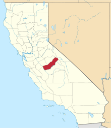 Madera County map | |
| CDPs | ||
| Unincorporated communities |
| |
| Indian reservations | ||
| Ghost towns | ||
| Authority control |
|
|---|