Weaverville, California
Weaverville is a census designated place and the county seat of Trinity County, California in the United States. The population was 3,600 at the 2010 census, up from 3,554 at the 2000 census.
Weaverville | |
|---|---|
Census designated place | |
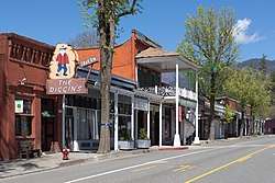 Main street in April 2020 | |
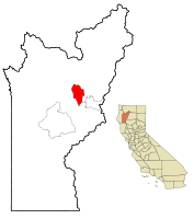 Location in Trinity County and the state of California | |
 Weaverville Location in the United States | |
| Coordinates: 40°44′12″N 122°56′10″W | |
| Country | |
| State | |
| County | Trinity |
| Area | |
| • Total | 10.424 sq mi (26.999 km2) |
| • Land | 10.424 sq mi (26.999 km2) |
| • Water | 0 sq mi (0 km2) 0% |
| Elevation | 2,051 ft (625 m) |
| Population (2010) | |
| • Total | 3,600 |
| • Density | 350/sq mi (130/km2) |
| Time zone | UTC−8 (Pacific) |
| • Summer (DST) | UTC−7 (PDT) |
| ZIP code | 96093 |
| Area code | 530 |
| FIPS code | 06-83794 |
| GNIS feature IDs | 1652649, 2409537 |
History
Founded in 1850, Weaverville is a historic California Gold Rush town. Located at the foot of the current Trinity Alps Wilderness Area, Weaverville was once home to approximately 2,000 Chinese gold miners, and had its own Chinatown. Logging and tourism were the economic mainstays of Weaverville for many years. The regional economy has been in steady decline for many years, with only a small uplift brought about by the global real estate bubble. Since 1990 the unemployment rate in the county has ranged from 4.3% in September 2018 to 25.0% in January 1992. The county's unemployment rate in July 2019 was 5.1%.[3]
Weaverville Joss House State Historic Park
The Weaverville Joss House (also called "The Temple of the Forest Beneath the Clouds"), a Taoist temple, was built in 1874 and is California's best preserved example of a Gold Rush-era Chinese place of worship. The temple is now the Weaverville Joss House State Historic Park, and its interior, including an intricately carved wooden altar, can be viewed by visitors.
Geography and climate
Weaverville is located at 40°44′12″N 122°56′10″W (40.736687, -122.936208).[4]
According to the United States Census Bureau, the CDP has a total area of 10.4 square miles (27 km2), all of it land.
Weaverville has a Mediterranean climate (Köppen Csa, bordering on Csb) though owing to its inland valley location the town is wetter and observes much larger diurnal temperature variations, creating colder mornings, than considered prototypical for the climate type. The National Weather Service has had a cooperative weather station in Weaverville since 1894. Based on those records, average January temperatures are a maximum of 47.2 °F or 8.4 °C and a minimum of 27.4 °F or −2.6 °C, whilst July temperatures average a maximum of 94.1 °F or 34.5 °C and a minimum of 49.1 °F or 9.5 °C. There are an average of 77.3 afternoons with highs of 90 °F or 32.2 °C or higher, plus an average of 126.8 mornings with lows of 32 °F or 0 °C or lower, although only two afternoons every three years fail to top freezing and only one morning every three years will fall to or below 0 °F or −17.8 °C. The record high temperature was 116 °F (46.7 °C) on August 4, 1932, and the record low temperature was −10 °F (−23.3 °C) on December 9, 1972.
Average annual precipitation is 35.45 inches or 900.4 millimetres, with an average of 83 days annually with measurable precipitation. The most precipitation in one month was 20.86 inches (529.8 mm) in December 2005, whilst the wettest “rain year” was from July 1982 to June 1983 with at least 65.82 inches or 1,671.8 millimetres (several days missing) and the driest from July 1990 to June 1991 with 19.02 inches (483.1 mm)[5] – although the 1976–77 “rain year” with many days in May missing had a recorded total of only 12.73 inches or 323.3 millimetres. The most precipitation in 24 hours was 5.50 inches (140 mm) on January 4, 1982. Average annual snowfall is 22.5 inches or 57.15 centimetres. The most snowfall in one month was 75.3 inches (191.26 cm) in January 1950.[6]
| Climate data for Weaverville | |||||||||||||
|---|---|---|---|---|---|---|---|---|---|---|---|---|---|
| Month | Jan | Feb | Mar | Apr | May | Jun | Jul | Aug | Sep | Oct | Nov | Dec | Year |
| Record high °F (°C) | 75 (24) |
82 (28) |
90 (32) |
94 (34) |
106 (41) |
113 (45) |
113 (45) |
116 (47) |
111 (44) |
104 (40) |
89 (32) |
85 (29) |
116 (47) |
| Average high °F (°C) | 47.3 (8.5) |
54.0 (12.2) |
59.6 (15.3) |
67.0 (19.4) |
76.2 (24.6) |
84.7 (29.3) |
94.1 (34.5) |
93.2 (34.0) |
86.9 (30.5) |
74.2 (23.4) |
56.7 (13.7) |
46.6 (8.1) |
70.0 (21.1) |
| Daily mean °F (°C) | 37.4 (3.0) |
41.7 (5.4) |
45.4 (7.4) |
50.7 (10.4) |
57.9 (14.4) |
64.7 (18.2) |
71.6 (22.0) |
70.2 (21.2) |
64.3 (17.9) |
54.7 (12.6) |
44.4 (6.9) |
38.0 (3.3) |
53.4 (11.9) |
| Average low °F (°C) | 27.6 (−2.4) |
29.4 (−1.4) |
31.3 (−0.4) |
34.4 (1.3) |
39.7 (4.3) |
44.9 (7.2) |
49.2 (9.6) |
47.3 (8.5) |
41.6 (5.3) |
35.3 (1.8) |
32.0 (0.0) |
29.3 (−1.5) |
36.8 (2.7) |
| Record low °F (°C) | −7 (−22) |
0 (−18) |
12 (−11) |
16 (−9) |
22 (−6) |
28 (−2) |
32 (0) |
29 (−2) |
23 (−5) |
11 (−12) |
0 (−18) |
−10 (−23) |
−10 (−23) |
| Average precipitation inches (mm) | 6.76 (172) |
5.37 (136) |
3.85 (98) |
2.35 (60) |
1.41 (36) |
0.80 (20) |
0.17 (4.3) |
0.26 (6.6) |
0.64 (16) |
2.35 (60) |
4.88 (124) |
6.61 (168) |
35.45 (900.9) |
| Average snowfall inches (cm) | 9.2 (23) |
4.1 (10) |
2.2 (5.6) |
0.4 (1.0) |
0.0 (0.0) |
0.0 (0.0) |
0.0 (0.0) |
0.0 (0.0) |
0.0 (0.0) |
0.0 (0.0) |
1.6 (4.1) |
4.9 (12) |
22.4 (55.7) |
| Average precipitation days | 12 | 11 | 10 | 8 | 6 | 3 | 1 | 1 | 2 | 6 | 10 | 12 | 82 |
| Source: Western Regional Climate Center[6] | |||||||||||||
Demographics
2010
At the 2010 census Weaverville had a population of 3,600. The population density was 345.4 people per square mile (133.3/km2). The racial makeup of Weaverville was 3,162 (87.8%) White, 11 (0.3%) African American, 152 (4.2%) Native American, 41 (1.1%) Asian, 1 (0.0%) Pacific Islander, 38 (1.1%) from other races, and 195 (5.4%) from two or more races. Hispanic or Latino of any race were 255 people (7.1%).[7]
The census reported that 3,473 people (96.5% of the population) lived in households, 61 (1.7%) lived in non-institutionalized group quarters, and 66 (1.8%) were institutionalized.
There were 1,513 households, 440 (29.1%) had children under the age of 18 living in them, 622 (41.1%) were married couples living together, 185 (12.2%) had a female householder with no husband present, 112 (7.4%) had a male householder with no wife present. There were 145 (9.6%) unmarried opposite-sex partnerships, and 12 (0.8%) same-sex married couples or partnerships. 473 households (31.3%) were one person and 196 (13.0%) had someone living alone who was 65 or older. The average household size was 2.30. There were 919 families (60.7% of households); the average family size was 2.80.
The age distribution was 842 people (23.4%) under the age of 18, 247 people (6.9%) aged 18 to 24, 734 people (20.4%) aged 25 to 44, 1,109 people (30.8%) aged 45 to 64, and 668 people (18.6%) who were 65 or older. The median age was 44.4 years. For every 100 females, there were 94.5 males. For every 100 females age 18 and over, there were 91.4 males.
There were 1,675 housing units at an average density of 160.7 per square mile, of the occupied units 908 (60.0%) were owner-occupied and 605 (40.0%) were rented. The homeowner vacancy rate was 2.8%; the rental vacancy rate was 6.8%. 2,089 people (58.0% of the population) lived in owner-occupied housing units and 1,384 people (38.4%) lived in rental housing units.
2000
At the 2000 census there were 3,554 people, 1,513 households, and 960 families in the CDP. The population density was 100.4 people per square mile (38.8/km2). There were 1,653 housing units at an average density of 46.7 per square mile (18.0/km2). The racial makeup of the CDP was 91.5% White, 0.3% African American, 2.9% Native American, 0.7% Asian, 0.1% Pacific Islander, 1.2% from other races, and 3.3% from two or more races. Hispanic or Latino of any race were 4.3%.[8]
Of the 1,513 households 27.9% had children under the age of 18 living with them, 47.1% were married couples living together, 12.4% had a female householder with no husband present, and 36.5% were non-families. 31.3% of households were one person and 13.8% were one person aged 65 or older. The average household size was 2.30 and the average family size was 2.85.
The age distribution was 24.2% under the age of 18, 6.4% from 18 to 24, 23.0% from 25 to 44, 28.0% from 45 to 64, and 18.4% 65 or older. The median age was 43 years. For every 100 females, there were 94.5 males. For every 100 females age 18 and over, there were 90.7 males.
The median household income was $30,319 and the median family income was $37,813. Males had a median income of $34,091 versus $24,722 for females. The per capita income for the CDP was $18,297. About 13.2% of families and 16.3% of the population were below the poverty line, including 23.6% of those under age 18 and 5.3% of those age 65 or over.
Government
In the California State Legislature, Weaverville is in the 2nd Senate District, represented by Democrat Mike McGuire, and in the 2nd Assembly District, represented by Democrat Jim Wood.[9]
In the United States House of Representatives, Weaverville is in California's 2nd congressional district, represented by Democrat Jared Huffman.[10]
Cultural references
- Junction City (about 8 miles from Weaverville) has a Tibetan Buddhist temple, Rigdzin Ling, part of the Chagdud Gonpa Foundation founded by Chagdud Tulku Rinpoche.
- The 1938 film Gold Is Where You Find It was filmed in and around Weaverville.
- The Mary McCaslin song "The Ballad of Weaverville" gives a fictional account of the town's name as being that of a gambler, Jim Weaver, who had the town named after him as his final bet, after winning all of the town's gold.[11]
References
- "2010 Census U.S. Gazetteer Files – Places – California". United States Census Bureau.
- "Weaverville". Geographic Names Information System. United States Geological Survey. Retrieved January 18, 2015.
- https://www.homefacts.com/unemployment/California/Trinity-County.html
- "US Gazetteer files: 2010, 2000, and 1990". United States Census Bureau. 2011-02-12. Retrieved 2011-04-23.
- National Weather Service, Eureka, CA; NOW Data: NOW Online
- "Weaverville, California (049490): Period of Record Monthly Climate Summary". Retrieved 4 December 2016.
- "2010 Census Interactive Population Search: CA - Weaverville CDP". U.S. Census Bureau. Archived from the original on July 15, 2014. Retrieved July 12, 2014.
- "U.S. Census website". United States Census Bureau. Retrieved 2008-01-31.
- "Statewide Database". UC Regents. Archived from the original on February 1, 2015. Retrieved December 6, 2014.
- "California's 2nd Congressional District - Representatives & District Map". Civic Impulse, LLC. Retrieved March 1, 2013.
- Ballad of Weaverville - Mary McCaslin, retrieved 2020-01-15
External links
| Wikimedia Commons has media related to Weaverville, California. |
Municipalities and communities of Trinity County, California, United States | ||
|---|---|---|
| CDPs | 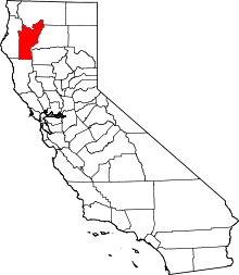 Trinity County map | |
| Unincorporated communities | ||
| Indian reservation | ||
| Ghost towns | ||
| Authority control |
|
|---|