Songdalen
Songdalen was an independent municipality until January 1, 2020 when the municipality was merged with the municipalities Søgne and Kristiansand into the "new" Kristiansand municipality. It is located in the traditional district of Sørlandet, just outside of the city of Kristiansand. The administrative centre of the municipality is the village of Nodeland. Other villages in the municipality include Brennåsen, Finsland, Kilen, Nodelandsheia, and Volleberg. The Sørlandsbanen railway line runs through the municipality, stopping at Nodeland Station. The European route E39 highway also runs through the southern part of the municipality.
Songdalen kommune | |
|---|---|
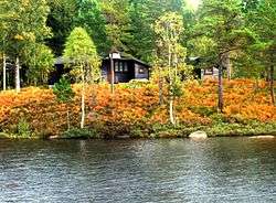
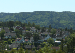 View of the Nodelandsheia area in Songdalen | |
 Coat of arms 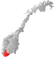 Agder within Norway | |
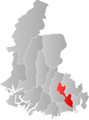 Songdalen within Agder | |
| Coordinates: 58°11′19″N 07°48′06″E | |
| Country | Norway |
| County | Agder |
| District | Sørlandet |
| Administrative centre | Nodeland |
| Government | |
| • Mayor (2003-2019) | Johnny Greibesland (Sp) |
| Area | |
| • Total | 215.94 km2 (83.37 sq mi) |
| • Land | 206.30 km2 (79.65 sq mi) |
| • Water | 9.64 km2 (3.72 sq mi) |
| Area rank | 323 in Norway |
| Population (2017) | |
| • Total | 6,568 |
| • Rank | 161 in Norway |
| • Density | 31.8/km2 (82/sq mi) |
| • Change (10 years) | 16.0% |
| Demonym(s) | Songdøl[1] |
| Time zone | UTC+01:00 (CET) |
| • Summer (DST) | UTC+02:00 (CEST) |
| ISO 3166 code | NO-1017 |
| Official language form | Neutral[2] |
| Website | www |
The 216-square-kilometre (83 sq mi) municipality is the 323rd largest by area out of the 422 municipalities in Norway. Songdalen is the 161st most populous municipality in Norway with a population of 6,568. The municipality's population density is 31.8 inhabitants per square kilometre (82/sq mi) and its population has increased by 16% over the last decade.[3]
General information
Songdalen was a relatively new municipality. During the 1960s, there were many municipal mergers across Norway due to the work of the Schei Committee. On 1 January 1964, the municipality of Greipstad (population: 2,061), most of the municipality of Finsland (population: 797) except for the Kleveland bru area, and the Eikeland area of Øvrebø (population: 39) were all merged to form the new municipality of Songdalen. On 1 January 1978, a small area of Vennesla municipality (population: 10) was transferred to Songdalen. Then on 1 January 1984, the unpopulated Hauglandsvatnet area was transferred from Vennesla to Songdalen.[4]
On 1 January 2020, the three neighboring municipalities of Kristiansand, Songdalen, and Søgne will be merged to form one large municipality called Kristiansand.[5]
Name
The municipality was named Songdalen. The Old Norse form of the name is uncertain. The first element is related to the river name Sygna (see Søgne), but the exact form and meaning is unknown. The last element is the finite form of dal which means "valley" or "dale".[6]
Coat-of-arms
The coat-of-arms is from modern times; they were granted on 20 December 1985. The arms are green with three gold-colored oak leaves in the center pointing towards each of the corners of the arms. The leaves represent each of the three former municipalities of Greipstad, Finsland, and Øvrebø which were merged to form the municipality of Songdalen in 1964. The oak was chosen since the area is heavily forested.[7]
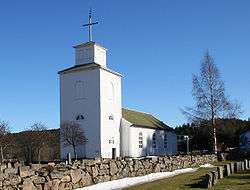
Churches
The Church of Norway has two parishes (sokn) within the municipality of Songdalen. It is part of the Mandal prosti (deanery) in the Diocese of Agder og Telemark.
| Parish (Sokn) | Church Name | Location of the Church | Year Built |
|---|---|---|---|
| Finsland | Finsland Church | Finsland | 1803 |
| Greipstad | Greipstad Church | Nodeland | 1829 |
Geography
Songdalen is an inland municipality, the municipalities of Kristiansand and Vennesla are located to the east, Marnardal to the west, and Søgne to the south. Songdalen's administrative centre, Nodeland, is a short 10-minute drive from the center of the city of Kristiansand.
The landscape of the municipality is heavily shaped by the last ice age. The river Songdalselva flows through the valley that makes up the southern part of the municipality. The river passes through a 1 kilometre (0.62 mi) long, 100 metres (330 ft) deep scenic narrow gorge called (Juve) at Underåsen. It is recognized for fishing, canoeing, and other recreational opportunities.
Southern Songdalen's elevation is close to sea level, but it increases up to a maximum of 414 metres (1,358 ft) above sea level in the northern part of the municipality. The climate changes correspondingly, from a coastal climate in the south to a more inland type climate in the north.
The forests are mixed deciduous and evergreen (heavily forested with oak and pine), with the ratio of pine woods increasing towards the north of the municipality. Moose and beaver are common in the area.[8]
Climate
| Climate data for Nodeland | |||||||||||||
|---|---|---|---|---|---|---|---|---|---|---|---|---|---|
| Month | Jan | Feb | Mar | Apr | May | Jun | Jul | Aug | Sep | Oct | Nov | Dec | Year |
| Daily mean °C (°F) | −2.2 (28.0) |
−2.2 (28.0) |
1.0 (33.8) |
4.6 (40.3) |
10.0 (50.0) |
14.1 (57.4) |
15.5 (59.9) |
14.8 (58.6) |
11.5 (52.7) |
7.5 (45.5) |
3.0 (37.4) |
−0.5 (31.1) |
6.4 (43.5) |
| Average precipitation mm (inches) | 141 (5.6) |
94 (3.7) |
100 (3.9) |
65 (2.6) |
94 (3.7) |
82 (3.2) |
93 (3.7) |
127 (5.0) |
160 (6.3) |
187 (7.4) |
187 (7.4) |
140 (5.5) |
1,470 (57.9) |
| Source: Norwegian Meteorological Institute[9] | |||||||||||||
Government
All municipalities in Norway, including Songdalen, are responsible for primary education (through 10th grade), outpatient health services, senior citizen services, unemployment and other social services, zoning, economic development, and municipal roads. The municipality is governed by a municipal council of elected representatives, which in turn elect a mayor.
Municipal council
The municipal council (Kommunestyre) of Songdalen is made up of 25 representatives that are elected to four year terms. Currently, the party breakdown is as follows:[10]
| Party Name (in Norwegian) | Number of representatives | |
|---|---|---|
| Labour Party (Arbeiderpartiet) | 6 | |
| Progress Party (Fremskrittspartiet) | 3 | |
| Green Party (Miljøpartiet De Grønne) | 1 | |
| Conservative Party (Høyre) | 3 | |
| Christian Democratic Party (Kristelig Folkeparti) | 4 | |
| Centre Party (Senterpartiet) | 7 | |
| Liberal Party (Venstre) | 1 | |
| Total number of members: | 25 | |
History
In 1964, Finsland and Greipstad municipalities, along with the Eikeland area of neighboring Øvrebø, were merged to form Songdalen municipality.
Greipstad is mentioned in written sources as early as 1344. Through the Middle Ages records indicate that Greipstad, a small farm community with 34 farms, was continuously inhabited. Greipstad became an independent municipality in 1913; split off from the municipality of Søgne.
Finsland, which lies further from the coast, has few preserved written records, but records have indications of farms there in the year 1000.
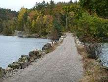
An 8-kilometre (5.0 mi) long section of the old Vestlandske Hovedvei (Westland Highway) passes through the municipality from Farvannet to Kvislevann. The highway was built in the 1790s and the section exists today in much the same way as it did for ordinary traffic in 1881.[11]
The fortifications at Rossevann were built in 1916-1917 for the Stavanger Battalion. The municipality also has visible evidence of World War II fortifications.
References
- "Navn på steder og personer: Innbyggjarnamn" (in Norwegian). Språkrådet.
- "Forskrift om målvedtak i kommunar og fylkeskommunar" (in Norwegian). Lovdata.no.
- Statistisk sentralbyrå (2017). "Table: 06913: Population 1 January and population changes during the calendar year (M)" (in Norwegian). Retrieved 2017-11-05.
- Jukvam, Dag (1999). "Historisk oversikt over endringer i kommune- og fylkesinndelingen" (PDF) (in Norwegian). Statistisk sentralbyrå.
- "Nye Kristiansand" (in Norwegian). Kristiansand kommune. Retrieved 2017-11-05.
- Store norske leksikon. "Songdalen" (in Norwegian). Retrieved 2017-01-13.
- "Civic heraldry of Norway - Norske Kommunevåpen". Heraldry of the World. Retrieved 2017-01-13.
- Stagg, Frank Noel (1958). South Norway. George Allen & Unwin, Ltd.
- "eKlima Web Portal". Norwegian Meteorological Institute. Archived from the original on 2004-06-14.
- "Table: 04813: Members of the local councils, by party/electoral list at the Municipal Council election (M)" (in Norwegian). Statistics Norway. 2015.
- Welle-Strand, Erling (1996). Adventure Roads in Norway. Nortrabooks. ISBN 9788290103717.
External links
- Municipal fact sheet from Statistics Norway (in Norwegian)


- Welcome to Songdalen - Tourist information
 |  | ||||||||||||||||||||
|