Audnedal
Audnedal was a municipality in Vest Agder county, Norway. It was located in the traditional district of Sørlandet. The administrative centre of the municipality was the village of Konsmo. Other villages in Audnedal include Byremo and Vivlemo.
Audnedal kommune | |
|---|---|
 Coat of arms 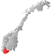 Agder within Norway | |
 Audnedal within Agder | |
| Coordinates: 58°22′48″N 07°22′12″E | |
| Country | Norway |
| County | Agder |
| District | Sørlandet |
| Administrative centre | Konsmo |
| Government | |
| • Mayor (2015) | Reidun Bakken (KrF) |
| Area | |
| • Total | 251.45 km2 (97.09 sq mi) |
| • Land | 236.04 km2 (91.14 sq mi) |
| • Water | 15.41 km2 (5.95 sq mi) |
| Area rank | 302 in Norway |
| Population (2017) | |
| • Total | 1,765 |
| • Rank | 341 in Norway |
| • Density | 7.5/km2 (19/sq mi) |
| • Change (10 years) | 10.7% |
| Demonym(s) | Audnedøl[1] |
| Time zone | UTC+01:00 (CET) |
| • Summer (DST) | UTC+02:00 (CEST) |
| ISO 3166 code | NO-1027 |
| Official language form | Neutral[2] |
| Website | www |
The 251-square-kilometre (97 sq mi) municipality was the 302nd largest by area out of the 422 municipalities in Norway. Audnedal was the 341st most populous municipality in Norway with a population of 1,765.[3]
General information

.jpg)
The old municipality of Undal was established in 1 January 1838 (see formannskapsdistrikt). That municipality only existed until 1845 when it was split into Nord-Audnedal and Sør-Audnedal. Those municipalities were later divided also. Sør-Audnedal was divided into Spangereid in 1899 and Nord-Audnedal was divided into Konsmo and Vigmostad in 1911. During the 1960s, there were many municipal mergers across Norway due to the work of the Schei Committee. This is when the present-day municipality of Audnedal was created. Audnedal was established as a municipality on 1 January 1964 when the municipality of Konsmo (population: 712), the municipality of Grindheim (population: 701), and the Ågedal and Midtbø areas (population: 96) of Bjelland municipality were merged. This new Audnedal municipality mostly corresponded to the historical borders of the old municipality of Nord-Audnedal.[4]
On 1 January 2020, the neighboring municipalities of Audnedal and Lyngdal merged into a new, larger municipality called Lyngdal.[5]
Name
The municipality was named after the Audnedalen valley in which it is located. The Old Norse form of the name was Auðnudalr. The first element is the genitive case of the river name Auðna (now Audna) and the last element is dalr which means "valley" or "dale". The river name is derived from the Norse word auðn which means "destruction" (because of flooding).[6]
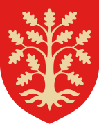
Coat-of-arms
The coat-of-arms is from modern times; they were granted on 30 August 1991. It shows a silver or white blade of a circular saw on a green background. This symbol was chosen to represent the timber and forestry industries in the municipality.[7]
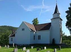
Churches
The Church of Norway had two parishes (sokn) within the municipality of Audnedal. It is part of the Mandal prosti (deanery) in the Diocese of Agder og Telemark.
| Parish (Sokn) | Church Name | Location of the Church | Year Built |
|---|---|---|---|
| Grindheim | Grindheim Church | Byremo | 1783 |
| Konsmo | Konsmo Church | Konsmo | 1802 |
Municipal council
The municipal council (Kommunestyre) of Audnedal was made up of 17 representatives that was elected to four year terms. The party breakdown was as follows in 2019:[8]
| Party Name (in Norwegian) | Number of representatives | |
|---|---|---|
| Labour Party (Arbeiderpartiet) | 3 | |
| Progress Party (Fremskrittspartiet) | 1 | |
| Conservative Party (Høyre) | 1 | |
| Christian Democratic Party (Kristelig Folkeparti) | 4 | |
| Centre Party (Senterpartiet) | 3 | |
| Local List(s) (Lokale lister) | 5 | |
| Total number of members: | 17 | |
Geography
Audnedal was an inland municipality, located in the Audnedalen valley which follows the river Audna. The municipality of Åseral bordered it to the north, Hægebostad to the west, Lyngdal and Lindesnes to the south, and Marnardal to the east. To the northeast, Audnedal bordered the municipality of Evje og Hornnes in neighboring Aust-Agder county.
Audnedal municipality had two large lakes: Ytre Øydnavatnet and Øvre Øydnavatnet. The Mandalselva river also passed through the northern part of the municipality.
Climate
| Climate data for Konsmo | |||||||||||||
|---|---|---|---|---|---|---|---|---|---|---|---|---|---|
| Month | Jan | Feb | Mar | Apr | May | Jun | Jul | Aug | Sep | Oct | Nov | Dec | Year |
| Average high °C (°F) | −0.1 (31.8) |
0.5 (32.9) |
2.9 (37.2) |
7.3 (45.1) |
13.2 (55.8) |
17.6 (63.7) |
18.6 (65.5) |
17.9 (64.2) |
13.4 (56.1) |
9.3 (48.7) |
4.5 (40.1) |
1.6 (34.9) |
8.9 (48.0) |
| Daily mean °C (°F) | −2.1 (28.2) |
−2.1 (28.2) |
0.2 (32.4) |
3.6 (38.5) |
8.8 (47.8) |
12.9 (55.2) |
14.2 (57.6) |
13.4 (56.1) |
9.9 (49.8) |
6.6 (43.9) |
2.2 (36.0) |
−0.7 (30.7) |
5.6 (42.1) |
| Average low °C (°F) | −4.7 (23.5) |
−5.0 (23.0) |
−2.6 (27.3) |
0.1 (32.2) |
4.8 (40.6) |
8.5 (47.3) |
9.9 (49.8) |
9.5 (49.1) |
7.0 (44.6) |
3.9 (39.0) |
−0.2 (31.6) |
−3.1 (26.4) |
2.3 (36.1) |
| Average precipitation mm (inches) | 154 (6.1) |
104 (4.1) |
107 (4.2) |
70 (2.8) |
104 (4.1) |
91 (3.6) |
102 (4.0) |
146 (5.7) |
195 (7.7) |
217 (8.5) |
210 (8.3) |
160 (6.3) |
1,660 (65.4) |
| Average precipitation days (≥ 1 mm) | 15.8 | 10.7 | 13 | 9 | 11 | 10 | 10.5 | 11.9 | 15.6 | 16.1 | 17.7 | 15.7 | 157 |
| Source: Norwegian Meteorological Institute[9] | |||||||||||||
Attractions
- "Blomliknuten" hiking trail
- Sveindal museum
- Fishing for salmon in the Mandalselva river
References
- "Navn på steder og personer: Innbyggjarnamn" (in Norwegian). Språkrådet.
- "Forskrift om målvedtak i kommunar og fylkeskommunar" (in Norwegian). Lovdata.no.
- Statistisk sentralbyrå (2017). "Table: 06913: Population 1 January and population changes during the calendar year (M)" (in Norwegian). Retrieved 2017-11-05.
- Jukvam, Dag (1999). "Historisk oversikt over endringer i kommune- og fylkesinndelingen" (PDF) (in Norwegian). Statistisk sentralbyrå.
- "Nye Lyngdal kommune Informasjonsbrosjyre" (PDF) (in Norwegian). Lyngdal kommune. Retrieved 2017-11-05.
- Store norske leksikon. "Audnedal" (in Norwegian). Retrieved 2016-11-19.
- "Civic heraldry of Norway - Norske Kommunevåpen". Heraldry of the World. Retrieved 2016-11-19.
- "Table: 04813: Members of the local councils, by party/electoral list at the Municipal Council election (M)" (in Norwegian). Statistics Norway. 2015.
- "eKlima Web Portal". Norwegian Meteorological Institute. Archived from the original on 2004-06-14.
External links


- Municipal fact sheet from Statistics Norway (in Norwegian)
 |  | ||||||||||||||||||||
|