Landvik
Landvik is a former municipality in Aust-Agder county, Norway. The 190.7-square-kilometre (73.6 sq mi) municipality existed from 1838 until its dissolution in 1971. The municipality's area is now located in the western and central part of the present-day municipality of Grimstad. The administrative centre was the village of Roresanden, just up the hill from the Landvik Church. Other villages in Landvik include Molland, Reddal, Skiftenes, Tjore, and Østerhus. Today, the name Landvik is still used to designate the westernmost part of the town of Grimstad, near the Prestegårdskogen housing development.[1][2]
Landvik kommune | |
|---|---|
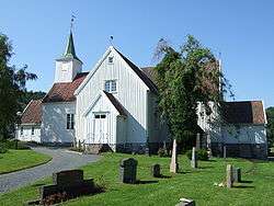 Landvik church | |
 Landvik kommune Location of the municipality  Landvik kommune Landvik kommune (Norway) | |
| Coordinates: 58°20′24″N 08°31′13″E | |
| Country | Norway |
| Region | Southern Norway |
| County | Aust-Agder |
| District | Østre Agder |
| Municipality ID | NO-0924 |
| Adm. Center | Roresanden |
| Area | |
| • Total | 190.7 km2 (73.6 sq mi) |
| Time zone | UTC+01:00 (CET) |
| • Summer (DST) | UTC+02:00 (CEST) |
| Created as | Formannskapsdistrikt in 1838 |
| Merged into | Grimstad in 1971 |
History
The parish of Hommedal was established as a municipality on 1 January 1838 (see formannskapsdistrikt). In 1865, the municipality was renamed Landvig. Originally, the municipal council met at the Torp farm in Reddal. Starting in the 1840s, the council met at the Landvik farm near the church. In 1876, the council began meeting at the Vikmarken school, just south of Roresanden. On 1 January 1883, the uninhabited Tolleholmen part of neighboring Birkenes municipality was transferred to Landvik. In 1956, the municipal council began meeting at the Landvik herredshus in Roresanden.[2][3]
During the 1960s, there were many municipal mergers across Norway due to the work of the Schei Committee. On 1 January 1962, the uninhabited area of Salvestjønn in neighboring Øyestad municipality and most of the municipality of Eide (504 inhabitants) were merged into the municipality of Landvik. After the merger, Landvik had a total of 2,433 residents.
Then on 1 January 1971, the neighboring municipalities of Landvik and Fjære were merged with the town of Grimstad to create a new, larger municipality of Grimstad. Prior to the merger, Landvik had a population of 2,781.[4]
Maps
 Map of Landvik prior to 1962 (also showing Eide and Fjære municipalities and the town of Grimstad)
 Map of the area of Birkenes that was transferred to Landvik in 1883
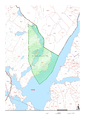 Map of the Salveskjenn area of Øyestad that was transferred to Landvik in 1962
Name
The municipality (and parish) is named after the old Landvig farm since that is where the local church was located. The first element of the name means "land" (Old Norse: Land) and the last element (Old Norse: Vík) is identical with the word vik which means "inlet". The farm is located on a bay on the northeast side of the Landvikvannet lake.[5] From 1838 until 1865, the municipality was named Hommedal. In 1865, it was changed to Landvig, and in the 20th century the spelling was adjusted to Landvik.
References
- Kiær, Anders Nicolai; Helland, Amund; Vibe, Johan; Strøm, Boye (1904). "Landvig herred". Norges land og folk: Nedenes amt (in Norwegian). Norway: H. Aschehoug & Company. p. 348. Retrieved 2017-11-07.
- Thorsnæs, Geir, ed. (2015-07-19). "Landvik – tidligere kommune". Store norske leksikon (in Norwegian). Kunnskapsforlaget. Retrieved 2017-11-07.
- "Grimstad rådhus" (in Norwegian). Grimstad kommune. Retrieved 2017-11-07.
- Jukvam, Dag (1999). "Historisk oversikt over endringer i kommune- og fylkesinndelingen" (PDF) (in Norwegian). Statistisk sentralbyrå. Cite journal requires
|journal=(help) - Rygh, Oluf (1905). Norske gaardnavne: Nedenes amt (in Norwegian) (8 ed.). Kristiania, Norge: W. C. Fabritius & sønners bogtrikkeri. p. 128.
External links
