Hægebostad
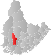
Hægebostad is a municipality in Agder county, Norway. It is located in the traditional district of Lister. The administrative centre of the municipality is the village of Tingvatn. Other villages in Hægebostad include Eiken, Haddeland, and Snartemo. The municipality encompasses the northern end of the Lyngdalen valley which follows the river Lygna.
Hægebostad kommune | |
|---|---|
 Coat of arms 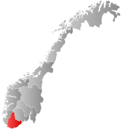 Agder within Norway | |
 Hægebostad within Agder | |
| Coordinates: 58°27′24″N 07°13′11″E | |
| Country | Norway |
| County | Agder |
| District | Lister |
| Administrative centre | Tingvatn |
| Government | |
| • Mayor (2015) | Margrethe Handeland (Sp) |
| Area | |
| • Total | 461.33 km2 (178.12 sq mi) |
| • Land | 424.26 km2 (163.81 sq mi) |
| • Water | 37.07 km2 (14.31 sq mi) |
| Area rank | 219 in Norway |
| Population (2017) | |
| • Total | 1,702 |
| • Rank | 344 in Norway |
| • Density | 4.0/km2 (10/sq mi) |
| • Change (10 years) | 6.4% |
| Demonym(s) | Hægdøl[1] |
| Time zone | UTC+01:00 (CET) |
| • Summer (DST) | UTC+02:00 (CEST) |
| ISO 3166 code | NO-4226 |
| Official language form | Nynorsk[2] |
| Website | www |
The Sørlandet Line runs through the municipality from east to west, stopping at Snartemo Station in Snartemo. To get into and out of the valley in which Hægebostad is located, the trains must go through two of the longest railway tunnels in Norway: Hægebostad Tunnel and Kvineshei Tunnel.
The 461-square-kilometre (178 sq mi) municipality is the 219th largest by area out of the 422 municipalities in Norway. Hægebostad is the 344th most populous municipality in Norway with a population of 1,702. The municipality's population density is 4 inhabitants per square kilometre (10/sq mi) and its population has increased by 6.4% over the last decade.[3]
General information


The parish of Hægebostad was established as a municipality on 1 January 1838 (see formannskapsdistrikt). On 1 January 1915, the municipality was divided into two municipalities: Eiken (population: 932) in the north and Hægebostad (population: 867) in the south. On 1 January 1963, the two municipalities were merged back together as the municipality of Hægebostad once again. Prior to the merger, Hægebostad had 813 residents and Eiken had 784 residents.[4]
Name
The municipality (originally the parish) is named after the old Hægebostad farm (Old Norse: Helgabólstaðir), since the first Hægebostad Church was built there. This farm is now on the north side of the village of Snartemo. The first element of the name is helg- which means "holy" and the last element is the plural form of bólstaðr which means "homestead" or "farm". Before 1889, the name was written Hegebostad.[5]
Coat-of-arms
The coat-of-arms is from modern times; they were granted on 4 April 1986. The arms show the two gold swords pointing downwards on a red background. The swords represent the two swards of Snartemo and Eiken dating from the 4th–6th century that were found in the municipality. The swords were highly decorated with silver and gold.[6]
Churches
The Church of Norway has two parishes (sokn) within the municipality of Hægebostad. It is part of the Lister deanery in the Diocese of Agder og Telemark.
| Parish (Sokn) | Church Name | Location of the Church | Year Built |
|---|---|---|---|
| Eiken | Eiken Church | Eiken | 1817 |
| Hægebostad | Hægebostad Church | Snartemo | 1844 |
Government
All municipalities in Norway, including Hægebostad, are responsible for primary education (through 10th grade), outpatient health services, senior citizen services, unemployment and other social services, zoning, economic development, and municipal roads. The municipality is governed by a municipal council of elected representatives, which in turn elect a mayor.
Municipal council
The municipal council (Kommunestyre) of Hægebostad is made up of 15 representatives that are elected to four year terms. Currently, the party breakdown is as follows:[7]
| Party Name (in Nynorsk) | Number of representatives | |
|---|---|---|
| Labour Party (Arbeidarpartiet) | 1 | |
| Progress Party (Framstegspartiet) | 3 | |
| Conservative Party (Høgre) | 3 | |
| Christian Democratic Party (Kristeleg Folkeparti) | 2 | |
| Centre Party (Senterpartiet) | 4 | |
| Local List(s) (Lokale lister) | 2 | |
| Total number of members: | 15 | |
Geography
Hægebostad is an inland municipality, with Åseral municipality to the northeast, Kvinesdal to the west, Lyngdal to the south, and Audnedal to the east. The municipality covers the upper Lyngdalen valley from the mountains in the north, along the river Lygna to Lyngdal municipality in the south. The lake Lygne lies in the central part of the municipality.
Climate
| Climate data for Skeie, near Eiken | |||||||||||||
|---|---|---|---|---|---|---|---|---|---|---|---|---|---|
| Month | Jan | Feb | Mar | Apr | May | Jun | Jul | Aug | Sep | Oct | Nov | Dec | Year |
| Daily mean °C (°F) | −2.3 (27.9) |
−2.4 (27.7) |
0.1 (32.2) |
3.5 (38.3) |
8.8 (47.8) |
13.0 (55.4) |
14.3 (57.7) |
13.4 (56.1) |
9.8 (49.6) |
6.4 (43.5) |
2.0 (35.6) |
−1.1 (30.0) |
5.5 (41.9) |
| Average precipitation mm (inches) | 156 (6.1) |
109 (4.3) |
110 (4.3) |
68 (2.7) |
95 (3.7) |
89 (3.5) |
99 (3.9) |
131 (5.2) |
178 (7.0) |
211 (8.3) |
200 (7.9) |
159 (6.3) |
1,605 (63.2) |
| Source: Norwegian Meteorological Institute[8] | |||||||||||||
References
- "Navn på steder og personer: Innbyggjarnamn" (in Norwegian). Språkrådet.
- "Forskrift om målvedtak i kommunar og fylkeskommunar" (in Norwegian). Lovdata.no.
- Statistisk sentralbyrå (2017). "Table: 06913: Population 1 January and population changes during the calendar year (M)" (in Norwegian). Retrieved 2017-11-04.
- Jukvam, Dag (1999). "Historisk oversikt over endringer i kommune- og fylkesinndelingen" (PDF) (in Norwegian). Statistisk sentralbyrå.
- Rygh, Oluf (1912). Norske gaardnavne: Lister og Mandals amt (in Norwegian) (9 ed.). Kristiania, Norge: W. C. Fabritius & sønners bogtrikkeri. p. 257.
- "Civic heraldry of Norway - Norske Kommunevåpen". Heraldry of the World. Retrieved 2016-10-29.
- "Table: 04813: Members of the local councils, by party/electoral list at the Municipal Council election (M)" (in Norwegian). Statistics Norway. 2015.
- "eKlima Web Portal". Norwegian Meteorological Institute. Archived from the original on 2004-06-14.
External links
| Wikimedia Commons has media related to Hægebostad. |
| Look up Hægebostad in Wiktionary, the free dictionary. |

- Municipal fact sheet from Statistics Norway (in Norwegian)
- Municipal website (in Norwegian)
 |  | ||||||||||||||||||||
|