Solomianskyi District
Solomianskyi District (Ukrainian: Солом'янський район, translit. Solom’ians’kyi raion, "district of Solomianka") is a district in Kyiv, the capital of Ukraine. Located in the western part of the city, in the basin of Lybid river, Dniepr's tributary. Named after village of Solomianka that became part of Kyiv in 1858. Established as a district in 1921. Reogarnized in 2001. An area of the district was settled since the Middle ages. The so-called mount of Batu Khan who invaded Kyiv in 1240 is located within the district.
Solomianskyi District Солом'янський район | |
|---|---|
 Flag  Coat of arms | |
.svg.png) | |
| Country | |
| Oblast | Kiev City Municipality |
| Area | |
| • Total | 40.05 km2 (15.46 sq mi) |
| Population | |
| • Total | 280,400 |
| • Density | 7,000/km2 (20,000/sq mi) |
| Time zone | UTC+2 (EET) |
| • Summer (DST) | UTC+3 (EEST) |
| Website | http://solor.gov.ua/ |
Neighbourhoods
- Grushki (Грушки) — hamlet of the 19th century. During 1871–1902 it belonged to nobleman K. Grushko (hence got its name).
- Karavayevi Dachi (Караваєві Дачі, "Karavayev's cottages") — area of border outposts outside of Kyiv in the XII—XIII c. In 1872 it was purchased by Russian doctor Vladimir Karavayev.
- Vidradnyi Відрадний
- Shuliavka (Шулявка) — mentioned under 1146 in the Hypatian Codex. In the 18th century this area was a residence of the Orthodox metropolitan bishops of Kyiv.
Education
Gallery
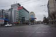 Solomianska Street looking east
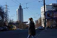 Solomianska street, with the Kyiv Court of Appeals building in the background
 Protasiv Yar Street
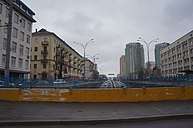 Traffic junction at Sevastopolska Square
External links
- solor.gov.ua - Solomianka Raion administration website (in Ukrainian)
- Солом`янка in Wiki-Encyclopedia Kyiv (in Ukrainian)
| Districts | |||||||
|---|---|---|---|---|---|---|---|
| Neighborhoods1 |
| ||||||
| |||||||
This article is issued from Wikipedia. The text is licensed under Creative Commons - Attribution - Sharealike. Additional terms may apply for the media files.