Darnytskyi District
Darnytskyi District (Ukrainian: Дарницький район, Darnyts'kyi raion), is an urban district of the Ukrainian capital Kiev.
Darnytskyi District Дарницький район | |
|---|---|
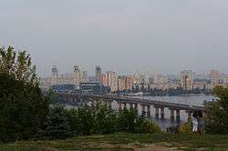 View on the Left Bank of Dnieper, with Darnytsia neighbourhoods seen on the right in the background | |
 Flag  Coat of arms | |
.svg.png) | |
| Coordinates: 50°24′22″N 30°40′36″E | |
| Country | |
| Oblast | Kiev City Municipality |
| Government | |
| • governnor | Genadiy Sinczov |
| Area | |
| • Total | 134 km2 (52 sq mi) |
| Population | |
| • Total | 285,400 |
| Time zone | UTC+2 (EET) |
| • Summer (DST) | UTC+3 (EEST) |
| Area code(s) | 38044 |
| Website | http://darn.kievcity.gov.ua |
It is the southeastern district of Kiev located on the left bank of Dnieper river. It borders the Dnieper to its west with Holosiivskyi District of Kiev is lying across it, Dniprovskyi District of Kiev city to its north, Brovary Raion of Kiev Oblast to its east and Boryspil Raion of Kiev Oblast to its east and south. The population of the city raion is estimated around 250,000 inhabitants.
Historical background
Although an exact date of establishment of the area is not known, there is evidence that during the 4th and 3rd centuries BC, a Neolithic settlement existed near lake Svyatyshche (Ukrainian: Святище). During the 9th century, Darnytsia was an important center of the Kievan Rus', where ambassadors and delegations from other powers were housed while waiting to meet the kniaz and offer gifts. This gave the area its name Darnytsia (derived from Slavic/Ukrainian dar, meaning gift).
While throughout the 19th century the area was progressively becoming more densely populated, the dwellers were technically residing outside of Kiev in village-like (but non-village by status) settlements called Slobidkas (Sloboda, Slobodka in Russian). Certain parts on Darnytsia still bear the names of the Slobidka they displaced (notably Mykilska Sloboda St. Nicholas Settlement).
Until the late 19th century, the name Darnytsia was commonly applied to the plain on the left bank of Dnieper river (Ukrainian: Dnipro) across from the Kiev city center. Up to the Bolshevik Revolution in 1917, the area was legally part of the Chernigov Governorate (Chernihiv), despite being adjacent to Kiev, also a center of its Guberniya, with the Dnieper river being the official division line. The village of Nova-Darnytsia and the rest of the area of the today's raion were incorporated into the city of Kiev in 1927. In 1935 Darnytsia became a separate raion of the city.
The urbanized area started industrializing between World War I and World War II, after becoming a part of Kiev. Following World War II, the area underwent a major reconstruction and modernization and became heavily industrialized, with the installation of chemical, textile, pharmaceutical and food processing industries. Major infrastructure projects, including heat-and-power co-generation units, railroad stations, highways and Metro lines were accomplished. Several research institutes found their new home here, including three major chemical institutes of the National Academy of Sciences of Ukraine.
Overview
Today, the term Darnytsia is sometimes broadly (but incorrectly) applied to the entire Left Bank area of Kiev, except the distant areas of Vigurovshchyna-Troyeshchyna to the North and Pozniaky to the South. Formally, the district underwent many border changes, and today encompasses approximately one-third of the Left Bank. A planned district change could make Darnytsia district either expand to encompass half of the Left Bank area or cease to exist being redistributed between Desna and Dnipro Raions.
- Neighborhood
The Darnytsia neighbourhood borders are generally understood to be:
- Mykil'ska Slobidka, Rusanivka Island and Berezniaky to the West
- Voskresenka, Troyeshchyna and Lisovyi masyv to the North
- Bykivnia neighborhood and the town of Bortnychi to the East
- Pozniaky, Osokorky and Kharkivskyi masyvs to the South
External links
- (in Ukrainian) darn.kievcity.gov.ua - Darnytskyi Raion Administration website
- (in Ukrainian) Дарниця in Wiki-Encyclopedia Kiev
| Districts | |||||||
|---|---|---|---|---|---|---|---|
| Neighborhoods1 |
| ||||||
| |||||||
| Authority control |
|
|---|