Obolonskyi District
Obolonskyi District (Ukrainian: Оболонський район, Obolons'kyi raion) is an urban district of the Ukrainian capital Kiev. Obolonskyi District encompasses territories far beyond of its historical neighborhood sharing the same name. It was formed on 3 March 1975 and initially called as Minskyi District. In 2001 it was renamed to its historical name. Its current population is 290,000 inhabitants.
Obolonskyi District Оболонський район | |
|---|---|
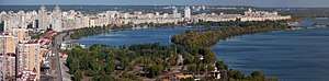 View on the Obolon bay | |
 Flag  Coat of arms | |
.svg.png) | |
| Country | |
| City Municipality | |
| Main neighborhoods | List
|
| Government | |
| • Council Head | Vadym Yahodka |
| Area | |
| • Total | 110.2 km2 (42.5 sq mi) |
| Population | |
| • Total | 306,000 |
| • Density | 2,776/km2 (7,190/sq mi) |
| Time zone | UTC+2 (EET) |
| • Summer (DST) | UTC+3 (EEST) |
| Landmarks | Obolon CJSC |
| Metro stations | Pochaina, Obolon, Minska, Heroiv Dnipra |
| Website | obolonrda |
Overview
During Soviet rule of Ukraine, Kiev had 14 administrative districts. In the early 21st century, a new law was passed and the city's administrative division was reorganized into 10 districts with different borders and new names.
The Obolonskyi District encompasses the territories of the former Minskyi District and is still sometimes referred to by that name. It also includes the former town of Pushcha-Vodytsia that used to be part of the Podilskyi District. The name Obolon comes from the Old-Ukrainian word оболонь → болонь → болоньє (obolon' → bolon' → bolon'ye), which roughly translates as "flood plain" or an area that is being engulfed by water. The district was built up in the 1970s as a microdistrict in Kiev on the Obolon sands to satisfy the growth of the city. Due to the composition of the soil at the time, the majority of the buildings were at most nine stories tall, and few trees were planted when compared to other parts of the city. That and few other reasons originally made the district not very prestigious.
With the second construction period (2000–2005), the district has seen new, comfortable apartment buildings constructed closer to the Dnieper river and has become an attractive residential area. The new apartments are also much more expensive, although still cheaper than in the central parts of Kiev. The district was connected by metro in the 1980s, with a station Obolon opened on 5 November 1980.
A yachting club for both kids and adults was opened in around 1990, and recently many of the Obolon lakes were cleaned up in order to make the area more attractive. The area closer to the Dnieper river is a popular relaxation place for Kiev residents. The area is also well known for the beer factory Obolon CJSC.
Park Natalka is among recreational spaces favored by Kiev residents. It is located along the Dnieper river.
Major neighborhoods
- Obolon, a residential area (masyv) and an industrial zone of the Kiev city. It is located between Dnieper river, Moscow Parkway, Verbova Street, and Dehtyarenko Street.
- Kurenivka, an area towards the downtown of Kiev. In the 17th century it used to be a suburb of the Kiev city where the Kiev Cossack Kosh was garrisoned. Its name is derived from one of the cossack's military formations, kurin (company). In the 18th century there was built the Petropavlivska Church that in the Soviet times was destroyed and rebuilt under one of the industrial buildings. Kurenivka is also became famous for a massive tragedy of the Kurenivka mudslide in 1961.
- Priorka, it is believed to be settled by monks (priors) of the Dominican Order on the road to Vyshhorod. Since 1834 the settlement was incorporated into the Kiev-city.
- Minsky masyv, a residential area (masyv) of Kiev. It is located between Shevchenko Square, Minsk Parkway, Konradyuk Street, Maiorov Street, Panch Street, Polyarna Street. The area also contains "sub-neighborhood" Kyn-Grust.
Gallery
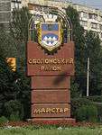 The sign when entering the district
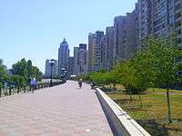 Obolon embankment
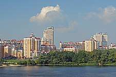 Bank of the Dnieper River
See also
External links
| Wikimedia Commons has media related to Obolon Raion. |
- Brief history of the Obolonskyi and Minskyi Districts
- (in Ukrainian) obolonrda.gov.ua – Obolonskyi District administration website
- (in Russian) Unofficial Kiev Metro site – Information about the Obolon metro station
- (in Ukrainian) Оболонь in Web Encyclopedia Kiev
| Neighborhoods1 |
| |
|---|---|---|
| Lakes, rivers, bays |
| |
| ||
| Districts | |||||||
|---|---|---|---|---|---|---|---|
| Neighborhoods1 |
| ||||||
| |||||||