Saint-Sauveur-Marville
Saint-Sauveur-Marville is a commune in the Eure-et-Loir department in northern France.
Saint-Sauveur-Marville | |
|---|---|
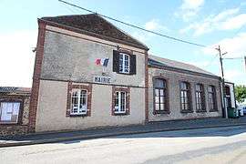 The town hall in Saint-Sauveur-Marville | |
Location of Saint-Sauveur-Marville 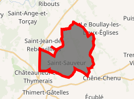
| |
 Saint-Sauveur-Marville  Saint-Sauveur-Marville | |
| Coordinates: 48°35′46″N 1°16′48″E | |
| Country | France |
| Region | Centre-Val de Loire |
| Department | Eure-et-Loir |
| Arrondissement | Dreux |
| Canton | Saint-Lubin-des-Joncherets |
| Intercommunality | Thymerais |
| Government | |
| • Mayor (2001–2008) | Jean Rouillon |
| Area 1 | 18.84 km2 (7.27 sq mi) |
| Population (2017-01-01)[1] | 925 |
| • Density | 49/km2 (130/sq mi) |
| Time zone | UTC+01:00 (CET) |
| • Summer (DST) | UTC+02:00 (CEST) |
| INSEE/Postal code | 28360 /28170 |
| Elevation | 134–202 m (440–663 ft) (avg. 187 m or 614 ft) |
| 1 French Land Register data, which excludes lakes, ponds, glaciers > 1 km2 (0.386 sq mi or 247 acres) and river estuaries. | |
Population
| Year | Pop. | ±% |
|---|---|---|
| 1962 | 403 | — |
| 1968 | 411 | +2.0% |
| 1975 | 390 | −5.1% |
| 1982 | 447 | +14.6% |
| 1990 | 640 | +43.2% |
| 1999 | 755 | +18.0% |
| 2008 | 944 | +25.0% |
References
- "Populations légales 2017". INSEE. Retrieved 6 January 2020.
| Wikimedia Commons has media related to Saint-Sauveur-Marville. |
| Authority control |
|
|---|
This article is issued from Wikipedia. The text is licensed under Creative Commons - Attribution - Sharealike. Additional terms may apply for the media files.