La Chapelle-du-Noyer
La Chapelle-du-Noyer is a commune in the Eure-et-Loir department in northern France.
La Chapelle-du-Noyer | |
|---|---|
 The church and surroundings in La Chapelle-du-Noyer | |
Location of La Chapelle-du-Noyer 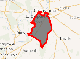
| |
 La Chapelle-du-Noyer  La Chapelle-du-Noyer | |
| Coordinates: 48°03′29″N 1°18′50″E | |
| Country | France |
| Region | Centre-Val de Loire |
| Department | Eure-et-Loir |
| Arrondissement | Châteaudun |
| Canton | Châteaudun |
| Intercommunality | Dunois |
| Government | |
| • Mayor (2008–2014) | Odil Billard |
| Area 1 | 13.31 km2 (5.14 sq mi) |
| Population (2017-01-01)[1] | 1,032 |
| • Density | 78/km2 (200/sq mi) |
| Time zone | UTC+01:00 (CET) |
| • Summer (DST) | UTC+02:00 (CEST) |
| INSEE/Postal code | 28075 /28200 |
| Elevation | 102–146 m (335–479 ft) (avg. 139 m or 456 ft) |
| 1 French Land Register data, which excludes lakes, ponds, glaciers > 1 km2 (0.386 sq mi or 247 acres) and river estuaries. | |
Population
| Year | Pop. | ±% |
|---|---|---|
| 1793 | 406 | — |
| 1800 | 370 | −8.9% |
| 1806 | 369 | −0.3% |
| 1821 | 309 | −16.3% |
| 1831 | 386 | +24.9% |
| 1836 | 433 | +12.2% |
| 1841 | 436 | +0.7% |
| 1846 | 469 | +7.6% |
| 1851 | 474 | +1.1% |
| 1856 | 495 | +4.4% |
| 1861 | 522 | +5.5% |
| 1866 | 516 | −1.1% |
| 1872 | 467 | −9.5% |
| 1876 | 503 | +7.7% |
| 1881 | 510 | +1.4% |
| 1886 | 505 | −1.0% |
| 1891 | 462 | −8.5% |
| 1896 | 422 | −8.7% |
| 1901 | 431 | +2.1% |
| 1906 | 425 | −1.4% |
| 1911 | 443 | +4.2% |
| 1921 | 692 | +56.2% |
| 1926 | 575 | −16.9% |
| 1931 | 628 | +9.2% |
| 1936 | 586 | −6.7% |
| 1946 | 469 | −20.0% |
| 1954 | 582 | +24.1% |
| 1962 | 620 | +6.5% |
| 1968 | 757 | +22.1% |
| 1975 | 831 | +9.8% |
| 1982 | 932 | +12.2% |
| 1990 | 967 | +3.8% |
| 1999 | 1,056 | +9.2% |
| 2008 | 1,028 | −2.7% |
References
- "Populations légales 2017". INSEE. Retrieved 6 January 2020.
| Wikimedia Commons has media related to La Chapelle-du-Noyer. |
| Authority control |
|
|---|
This article is issued from Wikipedia. The text is licensed under Creative Commons - Attribution - Sharealike. Additional terms may apply for the media files.