Saint-Philippe
Saint-Philippe is a commune in the French overseas department of Réunion. It is located in south-eastern Reunion.
Saint-Philippe | |
|---|---|
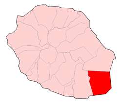 | |
Location of Saint-Philippe 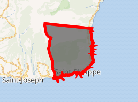
| |
| Coordinates: 21°21′34″S 55°46′04″E | |
| Country | France |
| Overseas region and department | Réunion |
| Arrondissement | Saint-Pierre |
| Canton | Saint-Benoît-2 |
| Government | |
| • Mayor (2014-2020) | Olivier Rivière |
| Area 1 | 153.94 km2 (59.44 sq mi) |
| Population (2017-01-01)[1] | 5,260 |
| • Density | 34/km2 (88/sq mi) |
| Time zone | UTC+04:00 |
| INSEE/Postal code | 97417 /97442 |
| Elevation | 0–2,630 m (0–8,629 ft) (avg. 40 m or 130 ft) |
| 1 French Land Register data, which excludes lakes, ponds, glaciers > 1 km2 (0.386 sq mi or 247 acres) and river estuaries. | |
Geography
Saint-Philippe is on the highest point on the island. It borders the municipalities of Saint-Joseph and Sainte-Rose, to the west and north respectively. Although it is a coastal area, the administrative centre is in Les Hauts (the highland area of the island).
History
A notable event in the commune's history was in 1897, when the British troopship RIMS Warren Hastings ran aground in the middle of the night. Two seamen died as a result, the crash sparked by a compass malfunction resulting from the eruption of the Piton de la Fournaise. On board the ship was some electricity, for which the village of Tremblet would have to wait until 1984 to finally receive.
References
- "Populations légales 2017". INSEE. Retrieved 6 January 2020.
| Wikimedia Commons has media related to Saint-Philippe (Réunion). |