Saint-Benoît, Réunion
Saint-Benoît (French pronunciation: [sɛ̃ bənwa] (![]()
Saint-Benoît | |
|---|---|
Subprefecture and commune | |
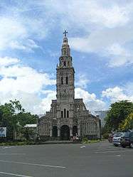 The church of Sainte-Anne in the commune of Saint-Benoît | |
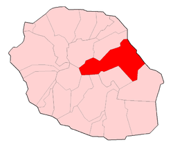 | |
Location of Saint-Benoît 
| |
| Coordinates: 21°02′02″S 55°42′46″E | |
| Country | France |
| Overseas region and department | Réunion |
| Arrondissement | Saint-Benoît |
| Canton | Saint-Benoît-1 and 2 |
| Intercommunality | Réunion Est |
| Government | |
| • Mayor (2014-2020) | Jean-Claude Fruteau (PS) |
| Area 1 | 229.61 km2 (88.65 sq mi) |
| Population (2017-01-01)[1] | 37,759 |
| • Density | 160/km2 (430/sq mi) |
| Time zone | UTC+04:00 |
| INSEE/Postal code | 97410 /97470 |
| Elevation | 0–2,520 m (0–8,268 ft) (avg. 7 m or 23 ft) |
| 1 French Land Register data, which excludes lakes, ponds, glaciers > 1 km2 (0.386 sq mi or 247 acres) and river estuaries. | |
Geography
In the west of the commune lies Grand Étang, the largest lake of La Réunion. Close to the lake flows the Bras d'Annette waterfall.
See also
References
- "Populations légales 2017". INSEE. Retrieved 6 January 2020.
| Wikimedia Commons has media related to Saint-Benoît (Réunion). |
| Authority control |
|
|---|
This article is issued from Wikipedia. The text is licensed under Creative Commons - Attribution - Sharealike. Additional terms may apply for the media files.