Roset-Fluans
Roset-Fluans is a commune in the Doubs department in the Bourgogne-Franche-Comté region in eastern France.
Roset-Fluans | |
|---|---|
 The chateau on the bank of the Doubs river, in Roset-Fluans | |
Location of Roset-Fluans 
| |
 Roset-Fluans 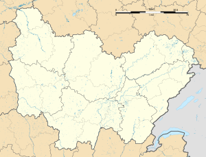 Roset-Fluans | |
| Coordinates: 47°09′51″N 5°49′35″E | |
| Country | France |
| Region | Bourgogne-Franche-Comté |
| Department | Doubs |
| Arrondissement | Besançon |
| Canton | Saint-Vit |
| Intercommunality | Grand Besançon Métropole |
| Government | |
| • Mayor (2008–2014) | Arnaud Grosperrin |
| Area 1 | 8.28 km2 (3.20 sq mi) |
| Population (2017-01-01)[1] | 520 |
| • Density | 63/km2 (160/sq mi) |
| Time zone | UTC+01:00 (CET) |
| • Summer (DST) | UTC+02:00 (CEST) |
| INSEE/Postal code | 25502 /25410 |
| Elevation | 214–357 m (702–1,171 ft) |
| 1 French Land Register data, which excludes lakes, ponds, glaciers > 1 km2 (0.386 sq mi or 247 acres) and river estuaries. | |
Geography
The commune lies 8 km (5.0 mi) northwest of Boussières. The Osselle cave is one of the oldest known caves in Franche-Comté. It was a refuge for priests during the French Revolution.
History
The commune was formed by merging four communes: Roset, Fluans, La Corne-de-Chaux, and Château-le-Bois. It also includes two villages: La Froidière and La Veloupe.
Château-le-Bois had 132 inhabitants in 1803, but is now completely covered by forest.
Population
| Year | Pop. | ±% |
|---|---|---|
| 1962 | 233 | — |
| 1968 | 238 | +2.1% |
| 1975 | 246 | +3.4% |
| 1982 | 266 | +8.1% |
| 1990 | 296 | +11.3% |
| 1999 | 374 | +26.4% |
| 2008 | 449 | +20.1% |
| 2012 | 475 | +5.8% |
See also
External links
| Wikimedia Commons has media related to Roset-Fluans. |
- Roset-Fluans on the regional Web site (in French)
| Authority control |
|
|---|
This article is issued from Wikipedia. The text is licensed under Creative Commons - Attribution - Sharealike. Additional terms may apply for the media files.