Pacific states
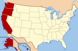
The West Pacific States form one of the nine geographic divisions within the United States that are officially recognized by that country's census bureau.[4] There are five states in this division – Alaska, California, Hawaii, Oregon, Washington – and, as its name suggests, they all have coastlines on the Pacific Ocean (and are the only US states that border that ocean). The Pacific States division is one of two divisions of the United States Census Bureau's Western region, the other being the Mountain States.
Pacific States | |
|---|---|
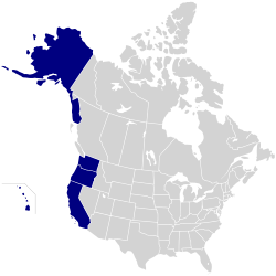 | |
 States in the U.S. Census Bureau's Pacific Division | |
| Area | |
• Total | 2,318,781[1] km2 (895,286 sq mi) (11th) |
| Population | |
• Estimate | 52,801,933[2] (27th) |
• Density | 22.8[2][1]/km2 (59.1/sq mi) (194th) |
| GDP (nominal) | 2018 estimate |
• Total | $4.1 trillion[3] |
• Per capita | $77,000[3][2] |
Despite being slotted into the same region by the Census Bureau, the Pacific, and Mountain divisions are vastly different from one another in many vital respects, most notably in the arena of politics; while nearly all of the Mountain states are regarded as being conservative "red states", four out of five of the Pacific states (all except Alaska) are clearly counted among the liberal "blue states".
Territories
| Historical population | |||
|---|---|---|---|
| Census | Pop. | %± | |
| 1900 | 2,634,285 | — | |
| 1910 | 4,448,534 | 68.9% | |
| 1920 | 5,877,788 | 32.1% | |
| 1930 | 8,622,011 | 46.7% | |
| 1940 | 10,228,556 | 18.6% | |
| 1950 | 15,114,964 | 47.8% | |
| 1960 | 21,198,044 | 40.2% | |
| 1970 | 26,524,131 | 25.1% | |
| 1980 | 31,799,705 | 19.9% | |
| 1990 | 39,127,306 | 23.0% | |
| 2000 | 45,025,637 | 15.1% | |
| 2010 | 49,880,102 | 10.8% | |
| Est. 2019 | 53,492,270 | 7.2% | |
| Source: 1910–2010[5] 2019 estimate[6] | |||
Although not states, the three inhabited pacific U.S. territories (American Samoa, Guam and the Northern Mariana Islands) and the pacific U.S. Minor Outlying Islands (excluding Navassa Island) are sometimes grouped with Pacific states in statistics.[7]
| City | City Population |
|---|---|
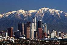 Los Angeles |
3,990,456 |
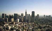 San Francisco |
883,305 |
 Seattle |
744,955 |
 San Diego |
1,425,976 |
San Jose |
1,030,119 |
 Oakland |
428,827 |
Portland |
653,115 |
Sacramento |
501,529 |
Fresno |
530,093 |
 Long Beach |
467,354 |
See also
- West Coast of the United States
- History of the West Coast of North America
References
- "State Population Totals Tables: 2010-2016". United States Census Bureau. Archived from the original on December 26, 2016. Retrieved July 3, 2017.
- "Gross Domestic Product by State:SecondQuarter 2018" (PDF). Bureau of Economic Analysis. Retrieved April 22, 2019.
- "Geographic Terms and Concepts - Census Divisions and Census Regions". United States Census Bureau. Retrieved April 29, 2012.
- Resident Population Data. "Resident Population Data – 2010 Census". 2010.census.gov. Archived from the original on December 20, 2012. Retrieved December 22, 2016.
- "QuickFacts Nevada; United States". 2019 Population Estimates. United States Census Bureau, Population Division. March 2, 2019. Archived from the original on December 27, 2018. Retrieved March 2, 2019.
- "Agency Information Collection Activities; Proposed Collection; Comment Request; Underground Storage Tank: Information Request Letters, Pacific Southwest Region (Region IX); EPA ICR No. 2405.01, OMB Control No. 2009-NEW". Federal Register. September 24, 2010. Retrieved April 22, 2019.
- "U.S. Census". United States Census Bureau. Retrieved March 16, 2020.
- "U.S. Census Region Map". August 17, 2000. Archived from the original on August 17, 2000. Retrieved March 16, 2020.
- "California Cities by Population". www.california-demographics.com. Retrieved March 16, 2020.
- "Oregon Cities by Population". www.oregon-demographics.com. Retrieved March 16, 2020.
- "Washington Cities by Population". www.washington-demographics.com. Retrieved March 16, 2020.