Nicut, Oklahoma
Nicut is an unincorporated community and census-designated place in Sequoyah County, Oklahoma, United States. Its population was 360 as of the 2010 census.[1]
Nicut, Oklahoma | |
|---|---|
 Nicut, Oklahoma  Nicut, Oklahoma | |
| Coordinates: 35°35′02″N 94°33′34″W | |
| Country | United States |
| State | Oklahoma |
| County | Sequoyah |
| Area | |
| • Total | 16.299 sq mi (42.21 km2) |
| • Land | 16.181 sq mi (41.91 km2) |
| • Water | 0.118 sq mi (0.31 km2) |
| Elevation | 581 ft (177 m) |
| Population | |
| • Total | 360 |
| • Density | 22/sq mi (8.5/km2) |
| Time zone | UTC-6 (Central (CST)) |
| • Summer (DST) | UTC-5 (CDT) |
| Area code(s) | 918 & 539 |
| GNIS feature ID | 1100673[2] |
History
Nicut was originally named Vrona; its post office changed its name on December 16, 1925. It was named for a "nigh cut", or shortcut, on the road to Muldrow. The community's post office closed on November 30, 1954.[3]
Geography
According to the U.S. Census Bureau, the community has an area of 16.299 square miles (42.21 km2); 16.181 square miles (41.91 km2) of its area is land, and 0.118 square miles (0.31 km2) is water.[1]
References
- "2010 Census Gazetteer Files - Places: Oklahoma". U.S. Census Bureau. Retrieved March 6, 2017.
- "Nicut". Geographic Names Information System. United States Geological Survey.
- Shirk, George H. (1974). Oklahoma Place Names (2 ed.). Norman, Oklahoma: University of Oklahoma Press. p. 171. ISBN 0806111402.
Municipalities and communities of Sequoyah County, Oklahoma, United States | ||
|---|---|---|
| City | 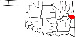 Sequoyah County map | |
| Towns | ||
| CDPs | ||
| Unincorporated communities | ||
| Indian reservation | ||
| Footnotes | ‡This populated place also has portions in an adjacent county or counties | |
This article is issued from Wikipedia. The text is licensed under Creative Commons - Attribution - Sharealike. Additional terms may apply for the media files.