Moncton Parish, New Brunswick
Moncton is a civil parish[lower-alpha 1] in Westmorland County, New Brunswick, Canada.[2]
Moncton | |
|---|---|
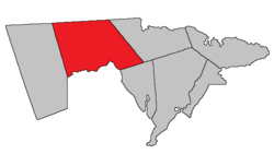 Location within Westmorland County, New Brunswick. | |
| Coordinates: 46.775555°N 65.48°W | |
| Country | |
| Province | |
| County | Westmorland County |
| Established | 1835 |
| Area | |
| • Land | 579.63 km2 (223.80 sq mi) |
| Population (2016)[1] | |
| • Total | 9,811 |
| • Density | 16.9/km2 (44/sq mi) |
| • Change 2011-2016 | |
| • Dwellings | 4,036 |
| Time zone | UTC-4 (AST) |
| • Summer (DST) | UTC-3 (ADT) |
For governance purposes it is divided between the cities of Dieppe and Moncton; the Indian reserves of Metepenagiag 3 Urban Reserve, Metepenagiag 8 Urban Reserve, and Soegao 35; and the local service district of the parish of Moncton,[3] which further includes the special service areas of Calhoun Road, Greater Lakeburn, Irishtown, and Painsec Junction.
History
The parish was established in 1765 as Monckton Township in the province of Nova Scotia and named for Robert Monckton (1726-1782), who was a distinguished soldier and civil servant: established as Moncton Parish in New Brunswick in 1786: part of the Parish of Dorchester was annexed by Moncton Parish in 1835.
Delineation
Moncton Parish is defined in the Territorial Division Act[2] as being bounded:
- East by Shediac Parish; north by the County line, west by that part of the east line of the grant to Martin Gay and associates, which lies north of Petitcodiac River; and the northerly prolongation thereof, to the County line; southerly by the Petitcodiac River and Dorchester Parish.
Communities
Parish population total does not include incorporated municipalities (in bold).
|
|
|
Demographics
Population
|
LanguageMother tongue (2016)[1]
| |||||||||||||||||||||||||||||||||||||||
Access routes
Highways and numbered routes that run through the parish, including external routes that start or finish at the parish limits:[7]
See also
Notes
- Civil parishes served a variety of government functions until 1966, when the new Municipalities Act stripped them of their responsibilities; they continue to provide convenient boundaries for government uses, especially electoral districts and local service districts. Statistics Canada uses civil parishes as census subdivisions for all parts of the province that are not within municipalities and similar entities.
References
- "Census Profile, 2016 Census: Moncton, Parish [Census subdivision], New Brunswick". Statistics Canada. Retrieved October 5, 2019.
- "Chapter T-3 Territorial Division Act". Government of New Brunswick. Retrieved 23 July 2020.
- "New Brunswick Regulation 84-168 under the Municipalities Act (O.C. 84-582)". Government of New Brunswick. Retrieved 23 July 2020.
- Statistics Canada: 2001, 2006 census
- "2006 Community Profile: Moncton Parish, New Brunswick". Statistics Canada. Retrieved October 5, 2019.
- 2011 Statistics Canada Census Profile: Moncton Parish, New Brunswick
- Atlantic Canada Back Road Atlas ISBN 978-1-55368-618-7
Places adjacent to Moncton Parish, New Brunswick | |
|---|---|
| Subdivisions |
|
|---|---|
| Cities | |
| Counties | |
| |