Milton Center, Ohio
Milton Center is a village in Wood County, Ohio, United States. The population was 144 at the 2010 census.
Milton Center, Ohio | |
|---|---|
 Village hall on Defiance Street | |
 Location of Milton Center, Ohio | |
 Location of Milton Center in Wood County | |
| Coordinates: 41°18′5″N 83°49′45″W | |
| Country | United States |
| State | Ohio |
| County | Wood |
| Township | Milton |
| Government | |
| • Type | Village Council |
| • Mayor | Debra Plath |
| Area | |
| • Total | 0.40 sq mi (1.03 km2) |
| • Land | 0.40 sq mi (1.03 km2) |
| • Water | 0.00 sq mi (0.00 km2) |
| Elevation | 689 ft (210 m) |
| Population | |
| • Total | 144 |
| • Estimate (2019)[4] | 146 |
| • Density | 366.83/sq mi (141.64/km2) |
| Time zone | UTC-5 (Eastern (EST)) |
| • Summer (DST) | UTC-4 (EDT) |
| ZIP code | 43541 |
| Area code(s) | 419 |
| FIPS code | 39-50708[5] |
| GNIS feature ID | 1080513[2] |
History
Milton Center was platted in 1857.[6] The village took its name from Milton Township.[7] A post office called Milton Centre was established in 1861, and the name was changed to Milton Center in 1893.[8] The village was incorporated in 1869.[9]
Geography
Milton Center is located at 41°18′5″N 83°49′45″W (41.301347, -83.829233).[10]
According to the United States Census Bureau, the village has a total area of 0.40 square miles (1.04 km2), all land.[11]
Demographics
| Historical population | |||
|---|---|---|---|
| Census | Pop. | %± | |
| 1880 | 106 | — | |
| 1890 | 334 | 215.1% | |
| 1900 | 325 | −2.7% | |
| 1910 | 350 | 7.7% | |
| 1920 | 194 | −44.6% | |
| 1930 | 188 | −3.1% | |
| 1940 | 226 | 20.2% | |
| 1950 | 201 | −11.1% | |
| 1960 | 251 | 24.9% | |
| 1970 | 244 | −2.8% | |
| 1980 | 181 | −25.8% | |
| 1990 | 200 | 10.5% | |
| 2000 | 195 | −2.5% | |
| 2010 | 144 | −26.2% | |
| Est. 2019 | 146 | [4] | 1.4% |
| U.S. Decennial Census[12] | |||
2010 census
As of the census[3] of 2010, there were 144 people, 53 households, and 37 families living in the village. The population density was 360.0 inhabitants per square mile (139.0/km2). There were 65 housing units at an average density of 162.5 per square mile (62.7/km2). The racial makeup of the village was 91.7% White, 0.7% Native American, 5.6% from other races, and 2.1% from two or more races. Hispanic or Latino of any race were 22.9% of the population.
There were 53 households, of which 34.0% had children under the age of 18 living with them, 50.9% were married couples living together, 15.1% had a female householder with no husband present, 3.8% had a male householder with no wife present, and 30.2% were non-families. 26.4% of all households were made up of individuals, and 11.4% had someone living alone who was 65 years of age or older. The average household size was 2.72 and the average family size was 3.35.
The median age in the village was 36.5 years. 31.2% of residents were under the age of 18; 4.2% were between the ages of 18 and 24; 20.9% were from 25 to 44; 27.2% were from 45 to 64; and 16.7% were 65 years of age or older. The gender makeup of the village was 46.5% male and 53.5% female.
2000 census
As of the census[5] of 2000, there were 195 people, 67 households, and 47 families living in the village. The population density was 488.3 people per square mile (188.2/km2). There were 73 housing units at an average density of 182.8 per square mile (70.5/km2). The racial makeup of the village was 90.26% White, 3.08% Native American, 5.13% from other races, and 1.54% from two or more races. Hispanic or Latino of any race were 17.44% of the population.
There were 67 households, out of which 31.3% had children under the age of 18 living with them, 55.2% were married couples living together, 13.4% had a female householder with no husband present, and 28.4% were non-families. 19.4% of all households were made up of individuals, and 6.0% had someone living alone who was 65 years of age or older. The average household size was 2.91 and the average family size was 3.27.
In the village, the population was spread out, with 26.2% under the age of 18, 12.8% from 18 to 24, 32.8% from 25 to 44, 17.4% from 45 to 64, and 10.8% who were 65 years of age or older. The median age was 35 years. For every 100 females there were 99.0 males. For every 100 females age 18 and over, there were 108.7 males.
The median income for a household in the village was $31,563, and the median income for a family was $42,083. Males had a median income of $30,417 versus $25,000 for females. The per capita income for the village was $13,513. About 6.4% of families and 9.7% of the population were below the poverty line, including 4.2% of those under the age of eighteen and none of those 65 or over.
References
- "2019 U.S. Gazetteer Files". United States Census Bureau. Retrieved July 28, 2020.
- "US Board on Geographic Names". United States Geological Survey. 2007-10-25. Retrieved 2008-01-31.
- "U.S. Census website". United States Census Bureau. Retrieved 2013-01-06.
- "Population and Housing Unit Estimates". United States Census Bureau. May 24, 2020. Retrieved May 27, 2020.
- "U.S. Census website". United States Census Bureau. Retrieved 2008-01-31.
- Leeson, Michael A. (1897). Commemorative Historical and Biographical Record of Wood County, Ohio: Its Past and Present, Early Settlement and Development. J.H. Beers & Company. p. 323.
- Overman, William Daniel (1958). Ohio Town Names. Akron, OH: Atlantic Press. p. 88.
- "Wood County". Jim Forte Postal History. Retrieved 11 January 2016.
- "Cities, Townships, & Villages". Wood County Government. Archived from the original on June 6, 2015. Retrieved 11 January 2016.CS1 maint: unfit url (link)
- "US Gazetteer files: 2010, 2000, and 1990". United States Census Bureau. 2011-02-12. Retrieved 2011-04-23.
- "US Gazetteer files 2010". United States Census Bureau. Archived from the original on 2012-01-25. Retrieved 2013-01-06.
- "Census of Population and Housing". Census.gov. Retrieved June 4, 2015.
Municipalities and communities of Wood County, Ohio, United States | ||
|---|---|---|
| Cities | 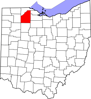 Map of Ohio highlighting Wood County | |
| Villages | ||
| Townships | ||
| CDPs | ||
| Other unincorporated communities | ||
| Footnotes | ‡This populated place also has portions in an adjacent county or counties | |