Marked Tree, Arkansas
Marked Tree is a city in Poinsett County, Arkansas United States, along the St. Francis River, at the mouth of the Little River. The population was 2,566 at the 2010 census. It is included in the Jonesboro, Arkansas Metropolitan Statistical Area.
Marked Tree, Arkansas | |
|---|---|
 Flag  Seal | |
 Location of Marked Tree in Poinsett County, Arkansas. | |
| Coordinates: 35°31′30″N 90°25′31″W[1] | |
| Country | United States |
| State | Arkansas |
| County | Poinsett |
| Area | |
| • Total | 5.81 sq mi (15.05 km2) |
| • Land | 5.77 sq mi (14.95 km2) |
| • Water | 0.04 sq mi (0.10 km2) |
| Elevation | 220 ft (67 m) |
| Population (2010) | |
| • Total | 2,566 |
| • Estimate (2019)[3] | 2,420 |
| • Density | 419.27/sq mi (161.88/km2) |
| Time zone | UTC-6 (Central (CST)) |
| • Summer (DST) | UTC-5 (CDT) |
| ZIP code | 72365 |
| Area code(s) | 870 |
| FIPS code | 05-44210 |
| GNIS feature ID | 2405025 [1] |
Geologically, the area marks the southern end of the New Madrid Fault.
Toponymy
The city got its name from a tree located on the bank of the St. Francis River until 1890 that had been blazed to mark a section of the river where Native Americans could walk about 120 yards (110 m) across land to reach the Little River and avoid paddling 12 mi (19 km) upstream.[4] Marked Tree has frequently been noted on lists of unusual place names.[5][6]
Geography
Marked Tree is located on the St. Francis River at the intersection of US Route 63 and Arkansas highways 140, 149 and 308. The south end of the Marked Tree Floodway lies just west of the city.[7]
According to the United States Census Bureau, the city has a total area of 2.3 square miles (6.0 km2), of which 2.3 square miles (6.0 km2) is land and 0.04 square miles (0.10 km2) (0.85%) is water.
Demographics
| Historical population | |||
|---|---|---|---|
| Census | Pop. | %± | |
| 1900 | 352 | — | |
| 1910 | 2,026 | 475.6% | |
| 1920 | 1,318 | −34.9% | |
| 1930 | 2,276 | 72.7% | |
| 1940 | 2,685 | 18.0% | |
| 1950 | 2,878 | 7.2% | |
| 1960 | 3,216 | 11.7% | |
| 1970 | 3,229 | 0.4% | |
| 1980 | 3,201 | −0.9% | |
| 1990 | 3,100 | −3.2% | |
| 2000 | 2,800 | −9.7% | |
| 2010 | 2,566 | −8.4% | |
| Est. 2019 | 2,420 | [3] | −5.7% |
| U.S. Decennial Census[8] | |||
As of the census[9] of 2000, there were 2,800 people, 1,126 households, and 731 families residing in the city. The population density was 1,208.8 people per square mile (466.0/km2). There were 1,234 housing units at an average density of 532.7 per square mile (205.4/km2). The racial makeup of the city was 50.36% White, 47.07% Black or African American, 0.11% Native American, 0.29% Asian, 1.25% from other races, and 0.93% from two or more races. 2.07% of the population were Hispanic or Latino of any race.
There were 1,126 households, out of which 29.7% had children under the age of 18 living with them, 41.9% were married couples living together, 19.4% had a female householder with no husband present, and 35.0% were non-families. 31.9% of all households were made up of individuals, and 14.5% had someone living alone who was 65 years of age or older. The average household size was 2.39 and the average family size was 3.04.
In the city, the population was spread out, with 26.5% under the age of 18, 8.4% from 18 to 24, 24.1% from 25 to 44, 21.9% from 45 to 64, and 19.1% who were 65 years of age or older. The median age was 38 years. For every 100 females, there were 87.4 males. For every 100 females age 18 and over, there were 79.0 males.
The median income for a household in the city was $22,591, and the median income for a family was $30,197. Males had a median income of $26,305 versus $19,602 for females. The per capita income for the city was $11,867. About 25.6% of families and 32.3% of the population were below the poverty line, including 47.4% of those under age 18 and 28.0% of those age 65 or over.
Education
Public education for early childhood, elementary and secondary school students is provided by the Marked Tree School District. Until 1966, a dual system of education was provided with one set of schools for white children, and a different set for blacks. The first school for blacks was built in 1938, and was named George Washington Carver from 1952 until it was closed in 1966.[10]
As of 2018, the Marked Tree School District consists of the following schools:
- Marked Tree Elementary School, serving prekindergarten through grade 6th
- Marked Tree High School, serving grades 7 through 12.
Notable people
- Fannie Lewis, Cleveland Ohio's longest serving councilwoman, was from Marked Tree and attended George Washington Carver High School.[10]
References
- U.S. Geological Survey Geographic Names Information System: Marked Tree, Arkansas
- "2019 U.S. Gazetteer Files". United States Census Bureau. Retrieved June 30, 2020.
- "Population and Housing Unit Estimates". United States Census Bureau. May 24, 2020. Retrieved May 27, 2020.
- "Colorful Names". Arkansas Department of Parks & Tourism. Archived from the original on November 24, 2013. Retrieved 14 July 2014.
- Hillinger, Charles (October 13, 1985). "Arkansas' Towns of Funny Names : There's Evening Shade, Greasy Corner, Stump City, Hope". Los Angeles Times. Retrieved 14 July 2014.
- Thompson, George E. (2009). You Live Where?: Interesting and Unusual Facts about where We Live. iUniverse. p. 8.
- Arkansas Atlas & Gazetteer, DeLorme, Second edition, 2004, p. 37 ISBN 0899333451
- "Census of Population and Housing". Census.gov. Retrieved June 4, 2015.
- "U.S. Census website". United States Census Bureau. Retrieved 2008-01-31.
- Schwarz, Ted (13 August 2008). "I'll Get My Rest When the Lord Is Done With Me Here". Retrieved 17 January 2019.
| Wikimedia Commons has media related to Marked Tree, Arkansas. |
External links
- Crittenden County Open Portal Website
- https://web.archive.org/web/20070114112944/http://www.markedtreearkansas.org/index.htm
Municipalities and communities of Poinsett County, Arkansas, United States | ||
|---|---|---|
| Cities | 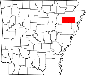 Map of Arkansas highlighting Poinsett County | |
| Town | ||
| Unincorporated communities | ||
| Authority control |
|
|---|