Arkansas Highway 308
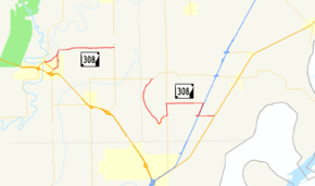
Highway 308 (AR 308, Ark. 308, and Hwy. 308) is a designation for two east–west state highways in the Arkansas Delta region of eastern Arkansas. One segment of 6.21 miles (9.99 km) runs east from U.S. Route 63 Business (US 63B) in Marked Tree to the Marked Tree Municipal Airport.[3] A second route of 10.94 miles (17.61 km) begins at Highway 118 at Whitton and runs east to US 61 at Frenchman's Bayou.[4] Both routes are maintained by the Arkansas State Highway and Transportation Department (AHTD).
| ||||
|---|---|---|---|---|
 | ||||
| Route information | ||||
| Maintained by ArDOT | ||||
| Existed | April 24, 1963[1]–present | |||
| Section 1 | ||||
| Length | 6.21 mi[2] (9.99 km) | |||
| West end | ||||
| East end | ||||
| Section 2 | ||||
| Length | 10.94 mi[2] (17.61 km) | |||
| West end | ||||
| East end | ||||
| Location | ||||
| Counties | Poinsett, Mississippi | |||
| Highway system | ||||
| ||||

Route description
Marked Tree to Spear Lake
The route runs north from US 63B in Marked Tree. The route turns east and runs to Spear Lake to terminate at Highway 135.
Whitton to Frenchman's Bayou
Highway 308 begins at Highway 118 and runs south to Birdsong. The route then turns north to concur with Highway 77 briefly. AR 308 continues east to cross Interstate 55 before terminating at US 61 in Frenchman's Bayou.
History
The segment between Marked Tree and Highway 135 was adopted as a state highway by the Arkansas State Highway Commission on April 24, 1963.[5] The spur route to the Marked Tree Municipal Airport was added to the system on June 24, 1970,[6] and the business route was created on March 28, 1973.[7]
The highway between Highway 118 and Birdsong was designated a state highway on April 25, 1973,[8] with an extension to Frenchman's Bayou on February 27, 1974.[9]
Major intersections
| County | Location | mi | km | Destinations | Notes | ||
|---|---|---|---|---|---|---|---|
| Poinsett | Marked Tree | 0.00 | 0.00 | Eastern terminus | |||
| 0.89 | 1.43 | Hwy. 308S western terminus | |||||
| 1.38 | 2.22 | Hwy. 308B eastern terminus | |||||
| Spear Lake | 6.21 | 9.99 | Eastern terminus | ||||
| Gap in route | |||||||
| Mississippi | Whitton | 0.00 | 0.00 | Western terminus | |||
| | 5.31– 0.00 | 8.55– 0.00 | |||||
| Frenchman's Bayou | 5.63 | 9.06 | Eastern terminus | ||||
1.000 mi = 1.609 km; 1.000 km = 0.621 mi
| |||||||
Special routes
Marked Tree spur
| |
|---|---|
| Location | Marked Tree |
| Length | 0.13 mi[2] (0.21 km) |
| Existed | June 24, 1970[6]–present |
Arkansas Highway 308 Spur is a 0.1-mile (0.16 km) spur route north of Marked Tree.
- Route description
- Major intersections
The entire route is in Marked Tree, Poinsett County.
| mi | km | Destinations | Notes | ||
|---|---|---|---|---|---|
| 0.00 | 0.00 | Western terminus | |||
| 0.13 | 0.21 | Marked Tree Municipal Airport | Eastern terminus | ||
| 1.000 mi = 1.609 km; 1.000 km = 0.621 mi | |||||
Marked Tree business route
| |
|---|---|
| Location | Marked Tree |
| Length | 1.37 mi[2] (2.20 km) |
| Existed | March 28, 1973[7]–present |
Arkansas Highway 308 Business, colloquially Elm Street, is a business route in Marked Tree. It is 1.3 miles (2.1 km) in length.
- Route description
- Major intersections
The entire route is in Marked Tree, Poinsett County.
| mi | km | Destinations | Notes | ||
|---|---|---|---|---|---|
| 0.00 | 0.00 | Eastern terminus | |||
| 1.37 | 2.20 | Western terminus | |||
| 1.000 mi = 1.609 km; 1.000 km = 0.621 mi | |||||
Former route
| |
|---|---|
| Location | Marked Tree |
| Length | 1.00 mi (1.61 km) |
| Existed | March 28, 1973–January 10, 1979 |
See also
- List of state highways in Arkansas
- Arkansas Highway 980, the traditional highway designation for airport roads in Arkansas
References
- "Minute Order 5017" (PDF). Minutes of the Meeting. ASHC. April 24, 1963. p. 919. Retrieved April 1, 2016.
- System Information and Research Division (2014). "Arkansas Road Log Database" (MDB). Arkansas State Highway and Transportation Department. Retrieved March 27, 2016.
- General Highway Map, Poinsett County, Arkansas (PDF) (Map). Cartography by Planning and Research Division. Arkansas State Highway and Transportation Department. March 23, 2016. Retrieved April 1, 2016.
- General Highway Map, Mississippi County, Arkansas (PDF) (Map). Cartography by Planning and Research Division. Arkansas State Highway and Transportation Department. March 23, 2016. Retrieved April 1, 2016.
- "Minute Order 73-156" (PDF). Minutes of the Meeting. ASHC. March 28, 1973. p. 1122. Retrieved March 31, 2016.
- "Minute Order 70-195" (PDF). Minutes of the Meeting. ASHC. June 24, 1970. p. 1636. Retrieved April 1, 2016.
- "Minute Order 73-152" (PDF). Minutes of the Meeting. ASHC. March 28, 1973. p. 1121. Retrieved April 1, 2016.
- "Minute Order 73-245" (PDF). Minutes of the Meeting. ASHC. April 25, 1973. p. 1141. Retrieved April 1, 2016.
- "Minute Order 74-104" (PDF). Minutes of the Meeting. ASHC. February 27, 1974. Retrieved April 1, 2016.
External links
![]()