List of National Historic Landmarks in Oklahoma
The List of National Historic Landmarks in Oklahoma contains the landmarks designated by the U.S. Federal Government for the U.S. state of Oklahoma.
There are 22 National Historic Landmarks in Oklahoma. The following table is a complete list.
| [1] | Landmark name | Image | Date designated[2] | Location | County | Description |
|---|---|---|---|---|---|---|
| 1 | 101 Ranch Historic District |  101 Ranch Historic District |
May 15, 1975 (#73001560) |
Ponca City 36°36′47″N 97°08′34″W |
Kay | Ranch where rodeo bull-dogging was developed to an art form by Bill Pickett; home base of 101 Ranch Wild West Show. |
| 2 | Bizzell Library |  Bizzell Library |
January 3, 2001 (#01000071) |
Norman 35°12′28″N 97°26′44″W |
Cleveland | Library of University of Oklahoma, focus of racial segregation Supreme Court case. |
| 3 | Boley Historic District |  Boley Historic District |
May 15, 1975 (#75001568) |
Boley 35°29′44″N 96°28′58″W |
Okfuskee | All-black town founded in 1903, product of segregationist policies. |
| 4 | Boston Avenue Methodist Episcopal Church, South | 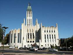 Boston Avenue Methodist Episcopal Church, South |
January 20, 1999 (#78002270) |
Tulsa 36°08′38″N 95°59′04″W |
Tulsa | One of finest examples of ecclesiastical Art Deco architecture in the U.S. |
| 5 | Camp Nichols | May 23, 1963 (#66000628) |
Wheeless 36°45′10″N 102°55′35″W |
Cimarron | Ruins of fort built by Kit Carson to protect the Cimarron Cutoff trail (Santa Fe Trail) followers from hostile Kiowa and Apache. | |
| 6 | Cherokee National Capitol | 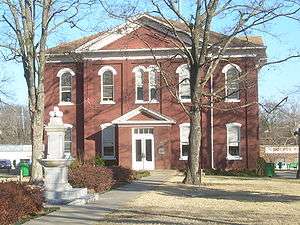 Cherokee National Capitol |
July 4, 1961 (#66000627) |
Tahlequah 35°54′38″N 94°58′14″W |
Cherokee | Capitol of the Cherokee nation from 1869 to 1907, when Oklahoma became a state. |
| 7 | Creek National Capitol | _Nation_Council_House.jpg) Creek National Capitol |
July 4, 1961 (#66000632) |
Okmulgee 35°37′24″N 95°58′18″W |
Okmulgee | Capitol of Creek nation from 1878 to 1907, now a museum. |
| 8 | Deer Creek Site | April 16, 1964 (#66000630) |
Newkirk |
Kay | Archeological site, site of a fortified village of the Wichita. | |
| 9 | Fort Gibson | .jpg) Fort Gibson |
December 12, 1960 (#66000631) |
Fort Gibson 35°48′14″N 95°15′26″W |
Muskogee | Fort built in 1824 in the Indian Territory. |
| 10 | Fort Sill |  Fort Sill |
December 12, 1960 (#66000629) |
Fort Sill 34°42′15″N 98°30′30″W |
Comanche | Only still-active fort from Indian wars on the south plains. |
| 11 | Fort Washita |  Fort Washita |
June 23, 1965 (#66000626) |
Nida 34°06′13″N 96°32′54″W |
Bryan | Established in 1842 to protect the Choctaws and Chickasaws from the plains Indians. |
| 12 | Guthrie Historic District | .jpg) Guthrie Historic District |
January 20, 1999 (#74001664) |
Guthrie 35°52′48″N 97°25′31″W |
Logan | Now a historic district. |
| 13 | Honey Springs Battlefield | 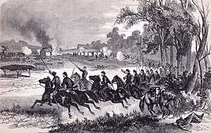 Honey Springs Battlefield |
February 27, 2013 (#13000280) |
Rentiesville 35°31′53″N 95°29′09″W |
McIntosh and Muskogee | Site of the Battle of Honey Springs, a Civil War battle known for its preponderance of non-white combatants. |
| 14 | Ernest Whitworth Marland Mansion |  Ernest Whitworth Marland Mansion |
December 22, 1977 (#73001561) |
Ponca City 36°43′01″N 97°03′38″W |
Kay | Home of Oklahoma politician Ernest Whitworth Marland. |
| 15 | McLemore Site | July 19, 1964 (#66000636) |
Colony |
Washita | An archeological site. | |
| 16 | Murrell Home | .jpg) Murrell Home |
May 30, 1974 (#70000530) |
Park Hill 35°51′21″N 94°57′32″W |
Cherokee | A house. |
| 17 | Platt National Park Historic District |  Platt National Park Historic District |
July 7, 2011 (#11000628) |
Sulphur 34°30′02″N 96°58′20″W |
Murray | Square mile sold by Chickasaw Nation to federal government for park use in 1902 |
| 18 | Price Tower | 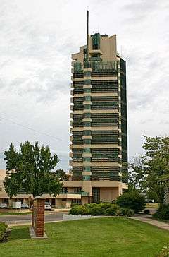 Price Tower |
March 29, 2007 (#74001670) |
Bartlesville 36°44′51″N 95°58′34″W |
Washington | A Frank Lloyd Wright designed building. His only realized skyscraper design completed in 1956, and commissioned by H.C. Price Petroleum Company. |
| 19 | Sequoyah's Cabin |  Sequoyah's Cabin |
December 21, 1965 (#66000634) |
Akins 35°30′51″N 94°39′07″W |
Sequoyah | Log cabin home of Sequoyah, who created "talking leaves", written language for the Cherokee. |
| 20 | Stamper Site | July 19, 1964 (#66000635) |
Optima |
Texas | Archeological site. | |
| 21 | Washita Battlefield |  Washita Battlefield |
January 12, 1965 (#66000633) |
Cheyenne 35°37′03″N 99°42′01″W |
Roger Mills | Where George Custer led the Seventh Cavalry surprise attack on village of Cheyenne Chief Black Kettle in 1868. |
| 22 | Wheelock Academy | December 21, 1965 (#66000949) |
Millerton 33°59′38″N 94°59′18″W |
McCurtain | Originally a missionary school for girls of the Choctaw nation, this became an academy and the model for other academies of the 5 civilized nations. |
See also
- National Register of Historic Places listings in Oklahoma
- List of National Historic Landmarks by state
References
- Numbers represent an ordering by significant words. Various colorings, defined here, differentiate National Historic Landmarks and historic districts from other NRHP buildings, structures, sites or objects.
- The eight-digit number below each date is the number assigned to each location in the National Register Information System database, which can be viewed by clicking the number.
External links
| Wikimedia Commons has media related to National Historic Landmarks in Oklahoma. |
- "National Register Information System". National Register of Historic Places. National Park Service. July 9, 2010.
| Topics | |
|---|---|
| Lists by state |
|
| Lists by insular areas | |
| Lists by associated state | |
| Other areas | |
| Related | |
| |
Oklahoma City (capital) | ||
| Topics |
|  |
| Society |
| |
| Regions | ||
| Largest cities | ||
| Counties |
| |
This article is issued from Wikipedia. The text is licensed under Creative Commons - Attribution - Sharealike. Additional terms may apply for the media files.