List of National Historic Landmarks in Colorado
This is a List of National Historic Landmarks in Colorado. A list of National Park Service administered areas in Colorado that have a historic focus is also included. There are 25 National Historic Landmark sites in Colorado.[1]
National Historic Landmarks in Colorado
| [2] | Landmark name | Image | Date designated[3] | Location | County | Description |
|---|---|---|---|---|---|---|
| 1 | Bent's Old Fort |  Bent's Old Fort |
December 19, 1960 (#66000254) |
La Junta 38°02′34″N 103°25′51″W |
Otero | Adobe fort built in 1833 to trade with Plains Indians and trappers, on Santa Fe Trail |
| 2 | Central City/Black Hawk Historic District | 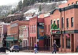 Central City/Black Hawk Historic District |
July 4, 1961 (#66000246) |
Central City and Black Hawk 39°48′04″N 105°30′27″W |
Gilpin | Former gold mining camps in the Front Range of the Rocky Mountains, once known as the 'Richest Square Mile on Earth |
| 3 | Colorado Chautauqua |  Colorado Chautauqua |
February 10, 2006 (#78000830) |
Boulder 39°59′52″N 105°16′50″W |
Boulder | This 1898 Chautauqua is the only one West of the Mississippi, one of only four continuously operating since its inception, and the only one open year round. |
| 4 | Cripple Creek Historic District |  Cripple Creek Historic District |
July 4, 1961 (#66000939) |
Cripple Creek 38°45′07″N 105°10′31″W |
Teller | The gold mining town of Cripple Creek and the surrounding hills |
| 5 | Denver & Rio Grande Railroad San Juan Extension(Cumbres & Toltec Scenic Railroad) | 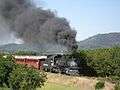 Denver & Rio Grande Railroad San Juan Extension |
October 16, 2012 (#73000462) |
Antonito, CO and Chama, NM 37°00′22″N 106°17′44″W |
Archuleta, CO, Conejos, CO, and Rio Arriba, NM | Longest & most complete representation of late nineteenth- and early twentieth-century railroading. |
| 6 | Denver Civic Center |  Denver Civic Center |
October 16, 2012 (#12001017) |
Denver 39°44′21″N 104°59′12″W |
Denver | City Beautiful-era civic center. |
| 7 | Durango-Silverton Narrow-Gauge Railroad |  Durango-Silverton Narrow-Gauge Railroad |
July 4, 1961 (#66000247) |
Durango to Silverton 37°17′51″N 107°42′39″W |
San Juan and La Plata | Narrow gauge mining railroad which has continued to serve as a tourist line between Durango and Silverton |
| 8 | Georgetown-Silver Plume Historic District | 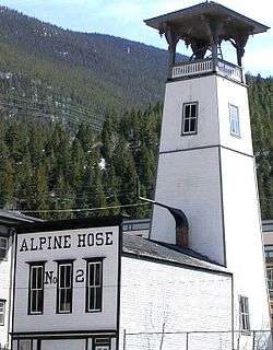 Georgetown-Silver Plume Historic District |
November 13, 1966 (#66000243) |
Georgetown and Silver Plume 39°41′55″N 105°42′48″W |
Clear Creek | Historic district which includes the silver mining towns of Georgetown and Silver Plume as well as the 1884 railway engineering marvel which connects them, the Georgetown Loop Railroad. |
| 9 | Granada Relocation Center |  Granada Relocation Center |
February 10, 2006 (#94000425) |
Granada 38°02′58″N 102°19′43″W |
Prowers | World War II Japanese American internment center |
| 10 | Leadville Historic District |  Leadville Historic District |
July 4, 1961 (#66000248) |
Leadville 39°14′39″N 106°13′42″W |
Lake | Historic Leadville, Colorado mining district and village area |
| 11 | Lindenmeier Site |  Lindenmeier Site |
January 20, 1961 (#66000249) |
Norfolk 40°58′48″N 105°03′44″W |
Larimer | The only extensive Folsom culture campsite yet found with artifacts dating from approximately 11200 BCE to 3000 BCE. |
| 12 | Lowry Ruin | 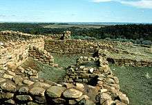 Lowry Ruin |
July 19, 1964 (#66000253) |
Pleasant View 37°35′04″N 108°55′11″W |
Montezuma | Ancestral Puebloan archaeological site from 1060 with a very large kiva |
| 13 | Ludlow Tent Colony Site |  Ludlow Tent Colony Site |
January 16, 2009 (#85001328) |
Ludlow 37°20′00″N 104°35′00″W |
Las Animas | Site of 1914 miners' strike that culminated in Ludlow Massacre |
| 14 | Mesa Verde Administrative District |  Mesa Verde Administrative District |
May 29, 1987 (#87001410) |
Mesa Verde National Park 37°10′53″N 108°29′26″W |
Montezuma | First buildings built by the National Park Service with intent to reflect cultural traditions in the park area, built in 1921 |
| 15 | Philadelphia Toboggan Company Carousel No. 6 |  Philadelphia Toboggan Company Carousel No. 6 |
February 27, 1987 (#78000861) |
Burlington 39°18′26″N 102°16′13″W |
Kit Carson | Carousel built for Elitch Gardens in 1905. In 1928 it moved to Kit Carson County fairgrounds where it remains open today. It is the only antique carousel in America retaining its original paint on both the scenery panels and the animals, and it is the only surviving Philadelphia Toboggan Company menagerie carousel. |
| 16 | Pikes Peak |  Pikes Peak |
July 4, 1961 (#66000245) |
Colorado Springs 38°50′26″N 105°02′39″W |
El Paso | Pike's Peak (everything above 14,000 feet (4,300 m) elevation). This mountain was inspiration for "America the Beautiful" as well as the motto "Pike's Peak or Bust" |
| 17 | Pike's Stockade |  Pike's Stockade |
July 4, 1961 (#66000244) |
Sanford 37°17′30″N 105°48′36″W |
Conejos | Explorer Zebulon Pike set up a fort here. |
| 18 | Raton Pass |  Raton Pass |
December 19, 1960 (#66000474) |
Trinidad, CO and Raton, NM 36°59′25″N 104°29′17″W |
Las Animas, CO and Colfax, NM | Mountain pass between New Mexico and Colorado |
| 19 | Red Rocks Park and Mount Morrison Civilian Conservation Corps Camp |  Red Rocks Park and Mount Morrison Civilian Conservation Corps Camp |
August 4, 2015 (#90000725) |
Morrison, CO 39°39′41″N 105°12′29″W |
Jefferson | Denver Mountain Park and camp where workers stayed while building the park's amphitheater. |
| 20 | Rocky Mountain National Park Administration Building |  Rocky Mountain National Park Administration Building |
January 3, 2001 (#01000069) |
Estes Park 40°21′58″N 105°33′39″W |
Larimer | Also known as the Beaver Meadows Visitor Center, it was designed by Taliesin Associated Architects, their first major work after Frank Lloyd Wright had died. It demonstrated how modern architecture could be successful inside the National Parks and was the last significant project in Mission 66. |
| 21 | Shenandoah-Dives (Mayflower) Mill | 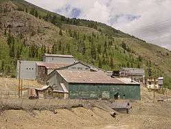 Shenandoah-Dives (Mayflower) Mill |
February 16, 2000 (#00000262) |
Silverton 37°49′44″N 107°37′42″W |
San Juan | Only surviving example of a selective flotation mill in Colorado. |
| 22 | Silverton Historic District |  Silverton Historic District |
July 4, 1961 (#66000255) |
Silverton 37°48′45″N 107°39′47″W |
San Juan | Former silver mining town, home of the Shenandoah-Dives (Mayflower) Mill and one end of the Durango-Silverton Narrow-Gauge Railroad |
| 23 | Telluride Historic District |  Telluride Historic District |
July 4, 1961 (#66000256) |
Telluride 37°56′14″N 107°48′29″W |
San Miguel | Former gold mining boomtown, it is now an artistic retreat and a ski resort town |
| 24 | Trujillo Homestead |  Trujillo Homestead |
February 1, 2012 (#03001544) |
Mosca 37°44′00″N 105°44′09″W |
Alamosa | Early ranch settlement (1880s) in the San Luis Valley, with a surviving period ranch house; located on a Nature Conservancy property near Great Sand Dunes National Park. |
| 25 | United States Air Force Academy, Cadet Area | 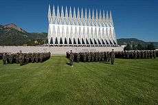 United States Air Force Academy, Cadet Area |
April 1, 2004 (#04000484) |
Colorado Springs 39°00′30″N 104°53′26″W |
El Paso | Bold use of Modern architecture at the United States Air Force Academy, especially with the Cadet Chapel |
Historic areas of the NPS in Colorado
National Historical Parks, some National Monuments, and certain other areas listed in the National Park system are historic landmarks of national importance that are highly protected already, often before the inauguration of the NHL program in 1960, and are then often not also named NHLs per se. There are four of these in Colorado. The National Park Service lists these four together with the NHLs in the state,[4]
Bent's Old Fort is a National Historic Site as well as a National Historic Landmark. The others are:
| Landmark name |
Image | Date established[5] | Location | County | Description | |
|---|---|---|---|---|---|---|
| 1 | Hovenweep National Monument |  |
March 2, 1923 | Cortez, CO and Blanding, UT | Montezuma, CO and San Juan, UT | Six clusters of Native American ruins; shared with Utah |
| 2 | Mesa Verde National Park |  |
June 29, 1906 | Cortez | Montezuma | Numerous ruins of homes and villages built by the ancient Pueblo people; known for cliff dwellings; Mesa Verde translates into English as "green table" |
| 3 | Yucca House National Monument | 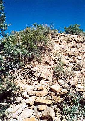 |
December 19, 1919 | Cortez | Montezuma | Unexcavated Ancestral Puebloan archaeological site |
See also
- List of Registered Historic Places in Colorado
- List of National Historic Landmarks by state
- Wikimedia Commons: National Historic Landmarks in Colorado
References
- National Park Service (June 2011). "National Historic Landmarks Survey: List of National Historic Landmarks by State" (PDF). Archived from the original (PDF) on 2011-11-05. Retrieved 2011-07-04..
- Numbers represent an ordering by significant words. Various colorings, defined here, differentiate National Historic Landmarks and historic districts from other NRHP buildings, structures, sites or objects.
- The eight-digit number below each date is the number assigned to each location in the National Register Information System database, which can be viewed by clicking the number.
- These are listed on p.111 of "National Historic Landmarks Survey: List of National Historic Landmarks by State", November 2007 version.
- Date of listing as National Historic Site or similar designation, from various sources in articles indexed.
External links

| Topics | |
|---|---|
| Lists by state |
|
| Lists by insular areas | |
| Lists by associated state | |
| Other areas | |
| Related | |
| |
This article is issued from Wikipedia. The text is licensed under Creative Commons - Attribution - Sharealike. Additional terms may apply for the media files.