Ardmore, Oklahoma
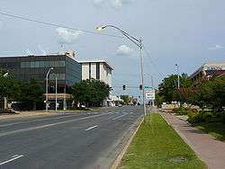
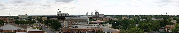
Ardmore is a business, cultural, and tourism city in and the county seat of Carter County, Oklahoma, United States.[5] As of the 2010 census, the city had a population of 24,283,[6] with an estimated population of 24,698 in 2019.[7] The Ardmore micropolitan statistical area had an estimated population of 48,491 in 2013.[8] Ardmore is 90 miles (140 km) from both Oklahoma City and Dallas/Fort Worth, Texas, at the junction of Interstate 35 and U.S. Highway 70, and is generally considered the hub of the 10-county region of South Central Oklahoma, also known by state tourism pamphlets as "Chickasaw Country" and previously "Lake and Trail Country". It is also a part of the Texoma region. Ardmore is situated about 9 miles (14 km) south of the Arbuckle Mountains and is located at the eastern margin of the Healdton Basin, one of the most oil-rich regions of the United States.
Ardmore, Oklahoma | |
|---|---|
 | |
 Seal | |
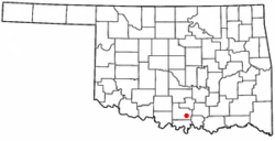 Location in the state of Oklahoma | |
| Coordinates: 34°10′52″N 97°7′46″W | |
| Country | United States |
| State | Oklahoma |
| County | Carter |
| Government | |
| • Mayor | John Moore |
| Area | |
| • Total | 51.83 sq mi (134.25 km2) |
| • Land | 49.93 sq mi (129.31 km2) |
| • Water | 1.91 sq mi (4.94 km2) |
| Elevation | 873 ft (266 m) |
| Population (2010) | |
| • Total | 24,283 |
| • Estimate (2019)[2] | 24,698 |
| • Density | 494.67/sq mi (191.00/km2) |
| Time zone | UTC−6 (CST) |
| • Summer (DST) | UTC−6 (CDT) |
| ZIP codes | 73401-73403 |
| Area code(s) | 580 |
| FIPS code | 40-02600[3] |
| GNIS feature ID | 1089691[4] |
| Website | www |
Ardmore was named after the affluent Philadelphia suburb and historic PRR Main Line stop of Ardmore, Pennsylvania, which was named after Ardmore in County Waterford, Ireland, by the Pennsylvania Railroad in 1873. The name "Ardmore" is Irish for high grounds or hills.
History
Ardmore, Indian Territory, began with a plowed ditch for a Main Street in the summer of 1887 in Pickens County, Chickasaw Nation. It owes much of its existence to the construction of the Santa Fe Railroad through the area during that time. It grew, as most frontier towns grew, over the years into a trading outpost for the region. In 1894, notorious outlaw William M. Dalton was gunned down by a posse as he tried to flee from his home in Ardmore. A large fire in 1895 destroyed much of the fledgling town, which forced residents to rebuild nearly the entire town.[9] In the early 1900s, Ardmore became well known for its abundance of cotton-growing fields and eventually became known as the world's largest inland cotton port.
After the fields were stripped of their fertility, however, the city found itself positioned next to one of the largest oil fields ever produced in Oklahoma, the Healdton Oil Field. After its discovery in 1913, entrepreneurs and wildcatters flooded the area, and Carter County quickly became the largest oil-producing county in Oklahoma, and has remained so ever since.[10] Ardmore has remained an energy center for the region ever since, with the region's natural wealth giving birth to such energy giants as Halliburton and the Noble Energy companies, among others. Ardmore also learned the perils of being energy-rich with yet another disaster in 1915, when a railroad car containing casing gas exploded, killing 45 people and destroying much of downtown, including areas rebuilt after the 1895 fire.[11] The disaster, which made national news, gave residents the resolve to establish the city's first fire department to ensure that such events would not recur in the future. The city has not experienced any major setbacks since the 1915 fire, save a 1995 tornado that nearly destroyed the Uniroyal Goodrich (now Michelin) tire plant in west Ardmore. Despite a shift at the plant working at the time, miraculously no one was killed as the tornado ripped through the area, due to the public being alerted by area news and tornado sirens. On April 22, 1966, Ardmore was the site of the worst plane crash in Oklahoma history, which killed 83 people.[12]
Ardmore was home to minor league baseball. The Ardmore Cardinals was the primary name of Ardmore teams that played as members of the Texas League (1904), Texas-Oklahoma League (1911–1914), Western Association (1917), Texas-Oklahoma League (1921–1922), Western Association (1923), Oklahoma State League (1924), Western Association (1924–1926), Sooner State League (1947–1957) and Texas League (1961). Ardmore captured league championships in 1923, 1925 and 1957. Ardmore was an affiliate of the Cleveland Indians (1947–1948), St. Louis Cardinals (1953–1957) and Baltimore Orioles (1961).[13]
Baseball Hall of Fame inductee Carl Hubbell played for the Ardmore Bearcats in 1924, his first professional season.[14]
Geography
Ardmore is located in southeastern Carter County at 34°10′52″N 97°07′46″W (34.181240, −97.129363).[15] It is bordered to the west by the city of Lone Grove and to the east by the town of Dickson. By Interstate 35, which passes through the west side of Ardmore, Oklahoma City is 97 miles (156 km) to the north, while Fort Worth, Texas, is 103 miles (166 km) to the south.
According to the United States Census Bureau, Ardmore has a total area of 51.8 square miles (134.1 km2), of which 49.9 square miles (129.2 km2) is land and 1.9 square miles (4.9 km2), or 3.67%, is water.[16]
Ardmore is located about 10 miles (16 km) south of the Arbuckle Mountains, an ancient, eroded range spanning some 62 mi (100 km) across southern Oklahoma. The geology is highly variegated within the area, with uplifted and folded ridges visible within the shoreline of some of the lakes surrounding Ardmore. The city of Ardmore has no intracity streams or rivers, but is part of the Washita and Red River watersheds, with two tributaries, Caddo and Hickory creeks, flanking the broad, low area in which Ardmore is situated. Ardmore is also 3.1 mi (5 km) north of Lake Murray, an impoundment of the two arms of Anadarche Creek, which eventually flows into the western reaches of Lake Texoma.
Climate
| Climate data for Ardmore, Oklahoma | |||||||||||||
|---|---|---|---|---|---|---|---|---|---|---|---|---|---|
| Month | Jan | Feb | Mar | Apr | May | Jun | Jul | Aug | Sep | Oct | Nov | Dec | Year |
| Record high °F (°C) | 83 (28) |
87 (31) |
92 (33) |
96 (36) |
97 (36) |
105 (41) |
109 (43) |
110 (43) |
107 (42) |
98 (37) |
87 (31) |
92 (33) |
110 (43) |
| Average high °F (°C) | 53 (12) |
57 (14) |
63 (17) |
74 (23) |
81 (27) |
91 (33) |
94 (34) |
96 (36) |
89 (32) |
77 (25) |
64 (18) |
55 (13) |
75 (24) |
| Average low °F (°C) | 29 (−2) |
34 (1) |
38 (3) |
50 (10) |
59 (15) |
68 (20) |
72 (22) |
70 (21) |
63 (17) |
51 (11) |
37 (3) |
31 (−1) |
50 (10) |
| Record low °F (°C) | −4 (−20) |
0 (−18) |
6 (−14) |
26 (−3) |
37 (3) |
48 (9) |
58 (14) |
54 (12) |
43 (6) |
25 (−4) |
13 (−11) |
5 (−15) |
−4 (−20) |
| Average precipitation inches (mm) | 1.8 (46) |
1.8 (46) |
2.4 (61) |
3.8 (97) |
5.8 (150) |
3.7 (94) |
3 (76) |
2.3 (58) |
3.5 (89) |
3.2 (81) |
1.5 (38) |
1.7 (43) |
34.3 (870) |
| Average snowfall inches (cm) | 2.1 (5.3) |
1 (2.5) |
0.5 (1.3) |
0 (0) |
0 (0) |
0 (0) |
0 (0) |
0 (0) |
0 (0) |
0 (0) |
0.1 (0.25) |
0.9 (2.3) |
4.6 (12) |
| Source: Weatherbase.com [17] | |||||||||||||
Demographics
| Historical population | |||
|---|---|---|---|
| Census | Pop. | %± | |
| 1900 | 5,681 | — | |
| 1910 | 8,618 | 51.7% | |
| 1920 | 14,181 | 64.6% | |
| 1930 | 15,741 | 11.0% | |
| 1940 | 16,886 | 7.3% | |
| 1950 | 17,890 | 5.9% | |
| 1960 | 20,184 | 12.8% | |
| 1970 | 20,881 | 3.5% | |
| 1980 | 23,689 | 13.4% | |
| 1990 | 23,079 | −2.6% | |
| 2000 | 23,711 | 2.7% | |
| 2010 | 24,283 | 2.4% | |
| Est. 2019 | 24,698 | [2] | 1.7% |
| Sources:[3][18][19][20][21][22] | |||
As of the census of 2010, there were 24,283 people living in the city.[23] The population density was 482.7 people per square mile (186.4/km2). There were 10,926 housing units at an average density of 222.4 per square mile (85.9/km2). The racial makeup of the city was 73.02% White, 11.27% African American, 8.78% Native American, 0.99% Asian, 0.02% Pacific Islander, 1.55% from other races, and 4.37% from two or more races. Hispanic or Latino of any race were 3.70% of the population.
There were 9,646 households, out of which 30.0% had children under the age of 18 living with them, 47.4% were married couples living together, 31.2% had a female householder with no husband present, and 34.6% were non-families. 14.7% of all households were made up of individuals, and 14.7% had someone living alone who was 65 years of age or older. The average household size was 2.36 and the average family size was 2.95.
In the city, the population was spread out, with 25.1% under the age of 18, 8.1% from 18 to 24, 25.8% from 25 to 44, 22.2% from 45 to 64, and 18.8% who were 65 years of age or older. The median age was 39 years. For every 100 females, there were 110.6 males. For every 100 females age 18 and over, there were 108.6 males.
The median income for a household in the city was $28,046, and the median income for a family was $37,758. Males had a median income of $28,685 versus $23,070 for females. The per capita income for the city was $16,502. About 13.6% of families and 18.3% of the population were below the poverty line, including 24.9% of those under age 18 and 12.0% of those age 65 or over.
Economy
Ardmore is the principal center of trade for a ten-county region in South Central Oklahoma, with a retail pull factor of 1.7–1.9. Ardmore's major employers are Michelin North America, with 1,900 employees, and Mercy Hospital Ardmore, with 900 employees. Several hundred employees work for regional distribution centers for Best Buy, Dollar Tree (Marietta) and Dollar General Stores, among others. Until early 2009, Ardmore was also home to a large regional distribution center for the now-defunct retail electronics chain Circuit City and was also home to a 1-800-flowers call center. In 2010 Ardmore lost another technology company, IMTEC, which was purchased by 3M and moved away to California. The 85,000 bbl/d (13,500 m3/d) Valero refinery in northeast Ardmore employs some 250 area residents. Ardmore is also home to the Samuel Roberts Noble Foundation, among the nation's 50 largest private foundations, primarily engaged in agricultural bioresearch activities. In 2001, East Jordan Iron Works opened a foundry located at the Ardmore Industrial Airpark.
Arts and culture
Ardmore is home to many pioneers in the dawn of the American oil industry and the wealth of the oil industry has been channeled into many philanthropical endeavors, as well as reinvested into the area in various art and infrastructure endowments.
Amenities include:
- Charles B. Goddard Center for the Visual and Performing Arts, which sponsors various exhibits and productions brought into the region
- Brass Ring Performing Arts Center
- Greater Southwest Historical Museum
- Ardmore Little Theatre
- Ardmore Convention Center, the newest convention facility in the region
- Ardmore Civic Auditorium, a historic city building that hosts concerts and other local events
- Hardy Murphy Coliseum, historic WPA-built facility that hosts rodeos, cutting shows and various regional events
The Ardmore Masonic Lodge is one of the oldest civic organizations in Ardmore.
Education
Colleges and universities
Ardmore is home to the University Center of Southern Oklahoma (a consortium-model system of higher education) which offers courses and degrees to the local population from four participating institutions of higher education: Murray State College, Southeastern Oklahoma State University, East Central University and Oklahoma State University (from the Oklahoma City campus).
Primary and secondary schools
Ardmore City Schools Ardmore City Schools, Plainview Public Schools , and the Ardmore Christian School operate public schools in Ardmore.
Ardmore-Oak Hall Episcopal School Oak Hall Episcopal School is one of only three Episcopal diocesan schools in the state of Oklahoma.
CareerTech
Southern Tech, in response to increasing demands, recently built a state-of-the-art Engineering Technology Building to house programs which directly address the employment needs of manufacturing-related companies. The 3D-CNC Machining program provides training designed to bring a student to an advanced level of understanding in the field of manufacturing processes currently used in both automated and non-automated industries. Mechatronics prepares students to become Automated Systems Technicians, covering robotics and fundamentals of electricity, electronics, programmable logic controllers, hydraulics, and pneumatics. Computer Aided Drafting, also located in the Engineering Technology building, has been producing graduates since 1968 and the need for skills in Computer Aided Design (CAD) is still on the rise today. Southern Tech offers a wide variety of additional courses designed for both high school and adult students seeking to develop a career or technical skills. New and exciting programs began in Pre-Engineering and Heavy Equipment Operation. Oklahoma University offers Dental Hygiene at the Southern Tech campus, and adult students may also enroll in the nationally certified Practical Nursing program. The BioTechnology Program at Southern Tech provides a realistic, hands-on opportunity to learn and experience biotechnology techniques and applications in human health, agriculture, environmental science, forensics and pharmaceutical production. There are many other training programs offered at Southern Tech in the automotive industry, health, human services, construction trades and the arts, and all programs end with qualified students leaving with a national or board certification, leading to higher wage-earning opportunities for students and a skilled workforce for businesses. Southern Tech also offers short-term training classes through the Corporate and Career Development Department. There is a vast array of courses provided to meet the needs of the district. Classes are offered at three locations as well as online. Corporate clients receive numerous safety and industry-specific training options and can also be served through customized training. The highly qualified instructors can teach on location or on campus and will work hard to fulfill the needs of the business. More information regarding the school and its offerings can be found at www.sotech.edu.
Media
Newspaper
- The Daily Ardmoreite, local newspaper since 1893.
Television
Transportation
Highways
Interstate 35 is passes through the western side of Ardmore, as it traverses the United States from Duluth, Minnesota, to Laredo, Texas.
Ardmore has four exits off I-35:
- Exit 29 (US-70 east)
- Exits 31A-B (State Highway 199 east/US-70 west, respectively)
- Exit 32 (12th St NW)
- Exit 33 (State Highway 142).
Ardmore is also home to the junction of US-70 and US-77, SH-142, and SH-199. Ardmore is connected to Lake Murray via State Highway 77S.
Airports
Ardmore has two general aviation airports, Ardmore Downtown Executive Airport and Ardmore Municipal Airport. The nearest scheduled air service occurs at Will Rogers World Airport in Oklahoma City and Dallas/Fort Worth International Airport, 99 miles (159 km) north and 95 miles (153 km) south of Ardmore, respectively. Ardmore is linked by rail with the DFW Airport via the Heartland Flyer to Trinity Railway Express connection.
Rail
Ardmore has one principal rail line,[24] that being one of the Burlington Northern Santa Fe mainlines running from Fort Worth, Texas to Oklahoma City (also connecting with Kansas City and Chicago), formerly part of the Atchison, Topeka and Santa Fe rail network before the merger with Burlington Northern. The line dates back to 1887, and the first train arrived on July 28 in that year.[25] The company has multiple parallel tracks (5+) running through central Ardmore (MP 450.5), added concomitantly with the rise of the trading status of the city and region throughout the early 1900s. There is also a lightly used transverse rail spur from the BNSF line to the Michelin tire plant in west Ardmore, mainly intended for the transport of raw materials to the factory.
Mass transit
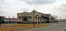
The historic Santa Fe depot in downtown Ardmore is also a stop on Amtrak's Heartland Flyer train route, with daily service to and from Oklahoma City and Fort Worth.
Ardmore also has a scheduled stop on the Greyhound/Jefferson Bus Lines system.
Southern Oklahoma Rural Transportation System (SORTS) began operations in 1985, and offers full services to the four counties of Bryan, Carter, Coal and Love. The program currently offers demand response services with contract transportation provided for work routes, medical routes and rural routes meeting the needs of the entire area.
In the early twentieth century, Ardmore had a fairly extensive traction (streetcar/interurban) railway system, franchised in February 1905, that linked outlying areas, such as the Dornick Hills Country Club, to the central business district.[25] The main part of the streetcar line originally ran down the center lane of Main Street. Service ended in 1922.
Historic Buildings
The following are still present in Ardmore:
- Ardmore Carnegie Library
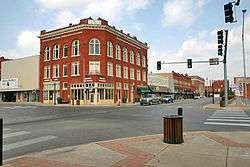
- Ardmore Historic Commercial District. Ardmore also has the Ardmore Main Street Authority, one of the various Main Street programs which act in the interests of commercial district revitalization.[26]
- Ardmore Municipal Auditorium
- Black Theater of Ardmore
- Carter County Courthouse
- Central Park Bandstand
- Dornick Hills Country Club
- Douglas High School Auditorium
- Dunbar School
- Galt-Franklin Home
- Hardy Murphy Coliseum
- Johnson Home
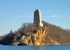
- Lake Murray State Park
- Oklahoma, New Mexico and Pacific Railroad Depot
- Sayre-Mann House
- Turner House
The NRHP-listed Choctaw, Oklahoma and Gulf Railroad Viaduct, previously in Ardmore, has been demolished. The Brady Cabin is given as 38 miles northwest of Ardmore.
Notable people
- Thomas Benson, linebacker for the Los Angeles Raiders and three other NFL teams
- Justin Blackmon, former wide receiver for Plainview High School, the Oklahoma State Cowboys, and the Jacksonville Jaguars
- Terry Cline Ph.D., former Oklahoma Health and Human Services Commissioner, former head of United States Substance Abuse and Mental Health Services Administration; born in Ardmore in 1958.
- Charles Coe, two-time U.S. Amateur golf champion, World War II combat pilot
- Eric Fields (b. June 14, 1982), professional boxer
- Mark Gastineau, former All-Pro NFL defensive star for New York Jets, born in Ardmore in 1956[27]
- Jake L. Hamon Sr., oil millionaire and murder victim
- Jermaine Gresham, former tight end for Ardmore High School and the Oklahoma Sooners; currently plays for the Arizona Cardinals
- John Hinckley, Jr., man who shot former President Ronald Reagan in failed assassination attempt in 1981; Hinckley's father worked for a local oil company
- Columbus Marion Joiner, father of East Texas Oil Field of 1930s, resided in and about Ardmore from 1897 to 1926[28]
- Terence C. Kern, United States District Judge (Northern District of Oklahoma)
- Walt Lamb, football player[29]
- B. P. Loughridge, the first Ardmore High School graduate to become a Fulbright scholar; became a cardiovascular surgeon, author, and health care consultant in Tulsa
- Rue McClanahan, Emmy award-winning actress best known for her role of Blanche Devereaux on The Golden Girls
- Joe McQueen (1919–2019), jazz musician, was raised in Ardmore
- Samuel Lloyd Noble (1896–1950), oilman and philanthropist, founder of Noble Corporation[30]
- Mike Pouncey, center for the Miami Dolphins, born in Ardmore in 1989; his twin brother is Maurkice Pouncey, center for the Pittsburgh Steelers
- Don K. Preston, theologian
- Rex Ryan, NFL head coach for Buffalo Bills and New York Jets, born in Ardmore in 1962; his twin brother is pro football coach Rob Ryan
- Russ Saunders, former fullback for Green Bay Packers
- Tom Tipps, Oklahoma businessman and legislator
- Carolyn Warner, politician
- Cameron Todd Willingham (1968–2004), convicted of triple murder and arson; executed
See also
References
- "2019 U.S. Gazetteer Files". United States Census Bureau. Retrieved July 28, 2020.
- "Population and Housing Unit Estimates". United States Census Bureau. May 24, 2020. Retrieved May 27, 2020.
- "U.S. Census website". United States Census Bureau. Retrieved 2008-01-31.
- "US Board on Geographic Names". United States Geological Survey. 2007-10-25. Retrieved 2008-01-31.
- "Find a County". National Association of Counties. Archived from the original on 2011-05-31. Retrieved 2011-06-07.
- "Ardmore's Population Grows 2.4% in the Last 10 Years". Archived from the original on 2013-01-17. Retrieved 2011-03-12.
- "Population and Housing Unit Estimates". Retrieved May 21, 2020.
- "Annual Estimates of the Resident Population: April 1, 2010 to July 1, 2013 - United States -- Micropolitan Statistical Area (GCT-PEPANNRES)". U.S. Census Bureau, American Factfinder. Archived from the original on February 12, 2020. Retrieved February 6, 2015.
- Bamburg, Maxine. "Ardmore" Archived 2009-09-16 at the Wayback Machine, Encyclopedia of Oklahoma History and Culture (accessed February 5, 2010).
- "2005 Oil & Gas Annual Report (charting oil production from 1975-2005), Oklahoma Corporation Commission (PDF)" (PDF). Archived (PDF) from the original on 2007-03-06. Retrieved 2007-05-01.
- Burton, Laura M. "Ardmore Gas Explosion Archived 2014-06-30 at the Wayback Machine," Encyclopedia of Oklahoma History and Culture (accessed February 5, 2010).
- http://www.airdisaster.com/cgi-bin/view_details.cgi?date=04221966®=N183H&airline=American+Flyers+Airline
- "Ardmore, OK - BR Bullpen". www.baseball-reference.com.
- "Carl Hubbell Minor Leagues Statistics & History". Baseball-Reference.com.
- "US Gazetteer files: 2010, 2000, and 1990". United States Census Bureau. 2011-02-12. Retrieved 2011-04-23.
- "Geographic Identifiers: 2010 Demographic Profile Data (G001): Ardmore city, Oklahoma". U.S. Census Bureau, American Factfinder. Archived from the original on February 10, 2015. Retrieved February 6, 2015.
- "Historical Weather for Ardmore, Oklahoma, United States".
- "Annual Estimates of the Resident Population: April 1, 2010 to July 1, 2013 (PEPANNRES): Incorporated Places in Oklahoma". U.S. Census Bureau, American Factfinder. Archived from the original on January 31, 2015. Retrieved February 6, 2015.
- "Population-Oklahoma" (PDF). U.S. Census 1910. U.S. Census Bureau. Retrieved 22 November 2013.
- "Population-Oklahoma" (PDF). 15th Census of the United States. U.S. Census Bureau. Retrieved 27 November 2013.
- "Number of Inhabitants: Oklahoma" (PDF). 18th Census of the United States. U.S. Census Bureau. Retrieved 22 November 2013.
- "Oklahoma: Population and Housing Unit Counts" (PDF). U.S. Census Bureau. Retrieved 22 November 2013.
- "2010 City Population and Housing Occupancy Status". U.S. Census Bureau. Retrieved October 18, 2013.
- "Rail Network Map, BNSF Texas Operating Region, 2005 (PDF)" (PDF). Archived from the original (PDF) on 2007-07-11. Retrieved 2007-07-05.
- "Events in the Early History of Ardmore, Oklahoma". Archived from the original on 11 July 2007. Retrieved 2007-07-05.
- "About Us". Ardmore Main Street. Retrieved February 22, 2020.
- "IMDB: Mark Gastineau". Archived from the original on 14 February 2008. Retrieved 2008-03-26.
- Jeff Reed (2014). "The "Dad" Of East Texas Oil – The Story of Columbus Marion Joiner". oilpro.com. Archived from the original on February 11, 2015. Retrieved February 10, 2015.
- "WALT LAMB". profootballarchives.com. Archived from the original on September 9, 2015. Retrieved October 29, 2015.
- "NOBLE, SAMUEL LLOYD (1896–1950)". Archived from the original on 2010-07-30. Retrieved 2009-10-28.
External links
Sister projects


- . Encyclopædia Britannica (11th ed.). 1911.
Municipalities and communities of Carter County, Oklahoma, United States | ||
|---|---|---|
| Cities | 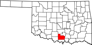 Carter County map | |
| Towns | ||
| Unincorporated communities | ||
| Ghost towns | ||
| Indian reservation | ||
| Footnotes | ‡This populated place also has portions in an adjacent county or counties | |
| Ardmore |
| |
|---|---|---|
| Healdton |
| |
| Tatums | ||
| Wilson |
| |
| Authority control |
|
|---|