Lipton, Saskatchewan
Lipton (2016 population: 345) is a village in the Canadian province of Saskatchewan within the Rural Municipality of Lipton No. 217 and Census Division No. 6. The village is located 17 km (11 mi) north of the Town of Fort Qu'Appelle on Highway 22.
_(33597143863).jpg)
Lipton | |
|---|---|
| Village of Lipton | |
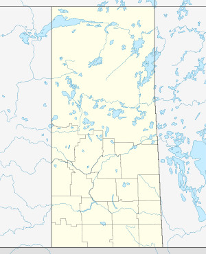 Location of Lipton in Saskatchewan  Lipton, Saskatchewan (Canada) | |
| Coordinates: 50.986°N 104.862°W | |
| Country | |
| Province | |
| Region | Southeast |
| Census division | 6 |
| Rural Municipality | Lipton No. 217 |
| Incorporated (Village) | 1905 |
| Government | |
| • Type | Municipal |
| • Governing body | Lipton Village Council |
| • Administrator | Cindy Baumgartener |
| • MLA | N/A |
| Area | |
| • Total | 0.75 km2 (0.29 sq mi) |
| Population (2016) | |
| • Total | 345 |
| • Density | 458.7/km2 (1,188/sq mi) |
| Time zone | UTC-6 (CST) |
| Postal code | S0G 3B0 |
| Area code(s) | 306 |
| Highways | |
| Railways | Canadian Pacific Railway |
| Website | Village of Lipton |
| [1][2][3][4] | |
History
Lipton incorporated as a village on May 15, 1905.[5]
Demographics
In the 2016 Census of Population conducted by Statistics Canada, the Village of Lipton recorded a population of 345 living in 158 of its 173 total private dwellings, a -7.8% change from its 2011 population of 372. With a land area of 0.75 km2 (0.29 sq mi), it had a population density of 460.0/km2 (1,191.4/sq mi) in 2016.[8]
In the 2011 Census of Population, the Village of Lipton recorded a population of 372, a 8.8% change from its 2006 population of 342. With a land area of 0.75 km2 (0.29 sq mi), it had a population density of 496.0/km2 (1,284.6/sq mi) in 2011.[9]
Climate
| Climate data for Lipton | |||||||||||||
|---|---|---|---|---|---|---|---|---|---|---|---|---|---|
| Month | Jan | Feb | Mar | Apr | May | Jun | Jul | Aug | Sep | Oct | Nov | Dec | Year |
| Record high °C (°F) | 7.5 (45.5) |
9.5 (49.1) |
19.5 (67.1) |
31.7 (89.1) |
39 (102) |
40.5 (104.9) |
38.5 (101.3) |
39.4 (102.9) |
36.1 (97.0) |
31 (88) |
22.2 (72.0) |
12.5 (54.5) |
40.5 (104.9) |
| Average high °C (°F) | −11.6 (11.1) |
−7.5 (18.5) |
−0.3 (31.5) |
10.6 (51.1) |
18.4 (65.1) |
22.6 (72.7) |
25 (77) |
24.7 (76.5) |
18.1 (64.6) |
10.7 (51.3) |
−1.3 (29.7) |
−9.1 (15.6) |
8.3 (46.9) |
| Daily mean °C (°F) | −17.1 (1.2) |
−12.8 (9.0) |
−5.7 (21.7) |
4.1 (39.4) |
11.2 (52.2) |
15.7 (60.3) |
18 (64) |
17.2 (63.0) |
11.2 (52.2) |
4.5 (40.1) |
−6.1 (21.0) |
−14.1 (6.6) |
2.2 (36.0) |
| Average low °C (°F) | −22.5 (−8.5) |
−18.2 (−0.8) |
−11.1 (12.0) |
−2.5 (27.5) |
4 (39) |
8.8 (47.8) |
10.9 (51.6) |
9.8 (49.6) |
4.2 (39.6) |
−1.9 (28.6) |
−10.8 (12.6) |
−19.1 (−2.4) |
−4 (25) |
| Record low °C (°F) | −46.7 (−52.1) |
−47.2 (−53.0) |
−41.7 (−43.1) |
−25 (−13) |
−10.6 (12.9) |
−7.2 (19.0) |
−1.7 (28.9) |
−5.6 (21.9) |
−12.8 (9.0) |
−23.5 (−10.3) |
−35.5 (−31.9) |
−45 (−49) |
−47.2 (−53.0) |
| Average precipitation mm (inches) | 24.3 (0.96) |
14.9 (0.59) |
23.9 (0.94) |
26.6 (1.05) |
53.2 (2.09) |
78.2 (3.08) |
68.7 (2.70) |
51.3 (2.02) |
39.3 (1.55) |
25.1 (0.99) |
16.4 (0.65) |
25.4 (1.00) |
447.2 (17.61) |
| Source: Environment Canada[10] | |||||||||||||
See also
- List of communities in Saskatchewan
- Villages of Saskatchewan
- Jewish Colonization Association § History
References
- National Archives, Archivia Net, Post Offices and Postmasters, archived from the original on 6 October 2006
- Government of Saskatchewan, MRD Home, Municipal Directory System, archived from the original (– Scholar search) on 21 November 2008
- Canadian Textiles Institute. (2005), CTI Determine your provincial constituency, archived from the original on 11 September 2007
- Commissioner of Canada Elections, Chief Electoral Officer of Canada (2005), Elections Canada On-line, archived from the original on 21 April 2007
- "Urban Municipality Incorporations". Saskatchewan Ministry of Government Relations. Archived from the original on 15 October 2014. Retrieved 1 June 2020.
- "Saskatchewan Census Population" (PDF). Saskatchewan Bureau of Statistics. Archived from the original (PDF) on 24 September 2015. Retrieved 31 May 2020.
- "Saskatchewan Census Population". Saskatchewan Bureau of Statistics. Retrieved 31 May 2020.
- "Population and dwelling counts, for Canada, provinces and territories, and census subdivisions (municipalities), 2016 and 2011 censuses – 100% data (Saskatchewan)". Statistics Canada. 8 February 2017. Retrieved 30 May 2020.
- "Population and dwelling counts, for Canada, provinces and territories, and census subdivisions (municipalities), 2011 and 2006 censuses (Saskatchewan)". Statistics Canada. 3 June 2019. Retrieved 30 May 2020.
- Environment Canada Canadian Climate Normals 1971–2000, accessed 5 August 2010
Places adjacent to Lipton, Saskatchewan | ||||||||||
|---|---|---|---|---|---|---|---|---|---|---|
| ||||||||||
